Holliston, Massachusetts

Submit your own pictures of this town and show them to the world
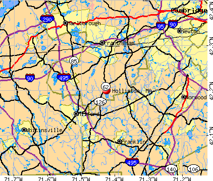
- OSM Map
- General Map
- Google Map
- MSN Map
Population change since 2000: -1.8%
 |
| Males: 6,667 | |
| Females: 6,880 |
| Median resident age: | 42.9 years |
| Massachusetts median age: | 39.2 years |
Zip codes: 01746.
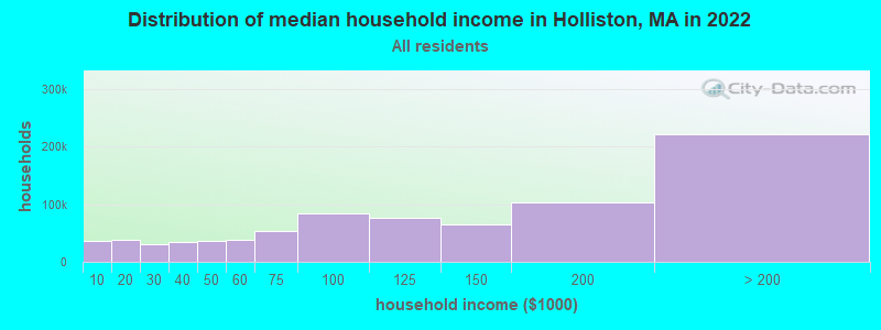
| Holliston: | $152,535 |
| MA: | $94,488 |
Estimated per capita income in 2022: $66,679 (it was $32,116 in 2000)
Holliston town income, earnings, and wages data
Estimated median house or condo value in 2022: $666,492 (it was $235,800 in 2000)
| Holliston: | $666,492 |
| MA: | $534,700 |
Mean prices in 2022: all housing units: $796,617; detached houses: $834,667; townhouses or other attached units: $772,440; in 2-unit structures: $786,250; in 3-to-4-unit structures: $655,835; in 5-or-more-unit structures: $590,321; mobile homes: $144,935
Detailed information about poverty and poor residents in Holliston, MA


Compare current foreclosures near Holliston, MA:
| Photo | Address | Area | Beds / Baths | Price | Details |
|---|---|---|---|---|---|

|
#1
Central St
Holliston, MA 01746
|
1,184 sq. feet
|
2 baths 4 beds |
show details | |

|
#2
Central St
Holliston, MA 01746
|
780 sq. feet
|
2 baths 3 beds |
show details | |

|
#3
Garett Way
Holliston, MA 01746
|
- sq. feet
|
- baths - beds |
show details | |

|
#4
Stillman St
Framingham, MA 01702
|
1,122 sq. feet
|
1 baths 2 beds |
$440,000
|
show details |

|
#5
Mount Pleasant Rd
Harrisville, RI 02830
|
1,232 sq. feet
|
1 baths 3 beds |
$449,900
|
show details |

|
#6
Cook Rd
Cumberland, RI 02864
|
2,050 sq. feet
|
2 baths 4 beds |
$749,500
|
show details |

|
#7
Wilson Ave
Dedham, MA 02026
|
- sq. feet
|
2 baths 3 beds |
show details | |

|
#8
Deer Path Apt 5
Maynard, MA 01754
|
1,540 sq. feet
|
1 baths 2 beds |
show details | |

|
#9
Boston Tpke
Shrewsbury, MA 01545
|
1,170 sq. feet
|
1 baths 3 beds |
show details | |

|
#10
Mount Hope St
North Attleboro, MA 02760
|
3,554 sq. feet
|
2 baths 4 beds |
show details |
| Photo | Address | Area | Beds / Baths | Price | Details |
|---|---|---|---|---|---|

|
#11
Marks Way
Maynard, MA 01754
|
2,596 sq. feet
|
2 baths 4 beds |
show details | |

|
#12
Victoria Cir
Norwood, MA 02062
|
2,980 sq. feet
|
3 baths 5 beds |
show details | |

|
#13
Washington St
Hyde Park, MA 02136
|
2,980 sq. feet
|
3 baths 5 beds |
show details | |

|
#14
Grove St
Woonsocket, RI 02895
|
2,534 sq. feet
|
3 baths 6 beds |
show details | |

|
#15
Mallard Dr
Medway, MA 02053
|
2,024 sq. feet
|
2 baths 5 beds |
show details | |

|
#16
Brahms St
Roslindale, MA 02131
|
1,604 sq. feet
|
1 baths 4 beds |
show details | |

|
#17
Briarwood Rd
Framingham, MA 01701
|
1,248 sq. feet
|
2 baths 3 beds |
show details | |

|
#18
Old Mill Rd
Shrewsbury, MA 01545
|
2,110 sq. feet
|
2 baths 3 beds |
show details | |

|
#19
Cedar St
Ashland, MA 01721
|
2,756 sq. feet
|
3 baths 4 beds |
show details | |

|
#20
Sidney Rd
Milford, MA 01757
|
1,184 sq. feet
|
1 baths 4 beds |
show details |
| Photo | Address | Area | Beds / Baths | Price | Details |
|---|---|---|---|---|---|

|
#21
Laurelwood Dr # No
Hopedale, MA 01747
|
1,440 sq. feet
|
1 baths 2 beds |
show details | |

|
#22
Baker St
West Roxbury, MA 02132
|
2,614 sq. feet
|
3 baths 4 beds |
show details | |

|
#23
Glendale Ave
Uxbridge, MA 01569
|
1,302 sq. feet
|
2 baths 4 beds |
show details | |

|
#24
Thompson St
Hyde Park, MA 02136
|
1,584 sq. feet
|
1 baths 4 beds |
show details | |

|
#25
Old Bolton Rd
Hudson, MA 01749
|
1,244 sq. feet
|
1 baths 3 beds |
show details | |

|
#26
Mill St
Foxboro, MA 02035
|
1,584 sq. feet
|
2 baths 3 beds |
show details | |

|
#27
W Hartford Ave
Uxbridge, MA 01569
|
1,992 sq. feet
|
2 baths 4 beds |
show details | |

|
#28
Stivaletta Dr
Dedham, MA 02026
|
1,148 sq. feet
|
1 baths 3 beds |
show details | |

|
#29
Charles St
Auburndale, MA 02466
|
2,899 sq. feet
|
3 baths 4 beds |
show details | |

|
#30
Rhode Island Ave
Woonsocket, RI 02895
|
2,080 sq. feet
|
2 baths 6 beds |
show details |
| Photo | Address | Area | Beds / Baths | Price | Details |
|---|---|---|---|---|---|

|
#31
Hazel St
Uxbridge, MA 01569
|
1,194 sq. feet
|
1 baths 3 beds |
show details | |

|
#32
Trilliam Run
Sutton, MA 01590
|
2,352 sq. feet
|
2 baths 4 beds |
show details | |

|
#33
High St
Uxbridge, MA 01569
|
1,296 sq. feet
|
1 baths 3 beds |
show details | |

|
#34
Meachen Ln
Sudbury, MA 01776
|
4,759 sq. feet
|
4 baths 5 beds |
show details | |

|
#35
Ironstone St
Millville, MA 01529
|
924 sq. feet
|
1 baths 4 beds |
show details | |

|
#36
Grove St
Woonsocket, RI 02895
|
1,156 sq. feet
|
1 baths 3 beds |
show details | |

|
#37
Ridge Hill Rd
Sudbury, MA 01776
|
2,288 sq. feet
|
2 baths 4 beds |
show details | |

|
#38
Worcester St
North Grafton, MA 01536
|
1,040 sq. feet
|
2 baths 3 beds |
show details | |

|
#39
Rolling Ln
Weston, MA 02493
|
1,572 sq. feet
|
2 baths 3 beds |
show details | |

|
#40
Partridge Dr
Westwood, MA 02090
|
4,487 sq. feet
|
4 baths 5 beds |
show details |
| Photo | Address | Area | Beds / Baths | Price | Details |
|---|---|---|---|---|---|

|
#41
Violet Ave
Dedham, MA 02026
|
857 sq. feet
|
1 baths 3 beds |
show details | |

|
#42
D St
Whitinsville, MA 01588
|
915 sq. feet
|
1 baths 3 beds |
show details | |

|
#43
Jeffers St
Woonsocket, RI 02895
|
1,794 sq. feet
|
2 baths 5 beds |
show details | |

|
#44
George St
Plainville, MA 02762
|
1,218 sq. feet
|
1 baths 3 beds |
show details | |

|
#45
Logee St
Woonsocket, RI 02895
|
1,270 sq. feet
|
1 baths 4 beds |
show details | |

|
#46
Commonwealth Ave
West Newton, MA 02465
|
1,809 sq. feet
|
2 baths 3 beds |
show details | |

|
#47
Main St
Hudson, MA 01749
|
1,074 sq. feet
|
2 baths 3 beds |
show details | |

|
#48
Cocasset St
Foxboro, MA 02035
|
1,092 sq. feet
|
1 baths 3 beds |
show details | |

|
#49
Creeper Hill Rd
North Grafton, MA 01536
|
1,104 sq. feet
|
1 baths 2 beds |
show details | |

|
Check over 1 million property listings on Foreclosure.com!
|
browse all offers | |||

- 12,64593.3%White alone
- 3312.4%Asian alone
- 2461.8%Hispanic
- 1331.0%Two or more races
- 1170.9%Black alone
- 610.5%Other race alone
- 120.09%American Indian alone
- 20.01%Native Hawaiian and Other
Pacific Islander alone
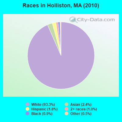
Races in Holliston detailed stats: ancestries, foreign born residents, place of birth
According to our research of Massachusetts and other state lists, there were 2 registered sex offenders living in Holliston, Massachusetts as of April 27, 2024.
The ratio of all residents to sex offenders in Holliston is 6,774 to 1.
The ratio of registered sex offenders to all residents in this city is much lower than the state average.
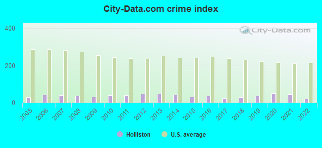
Type |
2009 |
2010 |
2011 |
2012 |
2013 |
2014 |
2015 |
2016 |
2017 |
2018 |
2019 |
2020 |
2021 |
2022 |
|---|---|---|---|---|---|---|---|---|---|---|---|---|---|---|
| Murders (per 100,000) | 0 (0.0) | 0 (0.0) | 0 (0.0) | 0 (0.0) | 0 (0.0) | 0 (0.0) | 0 (0.0) | 0 (0.0) | 0 (0.0) | 0 (0.0) | 0 (0.0) | 0 (0.0) | 0 (0.0) | 0 (0.0) |
| Rapes (per 100,000) | 1 (7.1) | 1 (7.4) | 0 (0.0) | 0 (0.0) | 0 (0.0) | 3 (20.9) | 1 (6.8) | 1 (6.8) | 1 (6.8) | 0 (0.0) | 1 (6.7) | 4 (26.7) | 3 (19.8) | 0 (0.0) |
| Robberies (per 100,000) | 0 (0.0) | 0 (0.0) | 0 (0.0) | 0 (0.0) | 0 (0.0) | 0 (0.0) | 1 (6.8) | 1 (6.8) | 2 (13.6) | 0 (0.0) | 1 (6.7) | 0 (0.0) | 1 (6.6) | 0 (0.0) |
| Assaults (per 100,000) | 4 (28.2) | 7 (51.7) | 6 (44.0) | 8 (57.9) | 14 (98.6) | 2 (13.9) | 4 (27.4) | 8 (54.6) | 5 (33.9) | 12 (80.4) | 12 (80.0) | 9 (60.1) | 6 (39.6) | 4 (27.1) |
| Burglaries (per 100,000) | 12 (84.7) | 18 (132.9) | 17 (124.7) | 23 (166.5) | 25 (176.1) | 23 (160.3) | 12 (82.2) | 13 (88.7) | 2 (13.6) | 5 (33.5) | 8 (53.3) | 9 (60.1) | 12 (79.3) | 9 (61.0) |
| Thefts (per 100,000) | 47 (331.9) | 44 (324.8) | 64 (469.6) | 78 (564.8) | 45 (316.9) | 38 (264.8) | 43 (294.5) | 39 (266.1) | 28 (190.0) | 35 (234.5) | 31 (206.7) | 34 (226.9) | 45 (297.3) | 41 (277.9) |
| Auto thefts (per 100,000) | 3 (21.2) | 5 (36.9) | 4 (29.3) | 5 (36.2) | 6 (42.3) | 1 (7.0) | 2 (13.7) | 3 (20.5) | 0 (0.0) | 0 (0.0) | 2 (13.3) | 7 (46.7) | 2 (13.2) | 2 (13.6) |
| Arson (per 100,000) | 1 (7.1) | 2 (14.8) | 0 (0.0) | 0 (0.0) | 1 (7.0) | 2 (13.9) | 1 (6.8) | 1 (6.8) | 0 (0.0) | 0 (0.0) | 0 (0.0) | 0 (0.0) | 0 (0.0) | 0 (0.0) |
| City-Data.com crime index | 32.2 | 41.5 | 38.7 | 48.7 | 48.1 | 41.9 | 31.6 | 36.9 | 24.8 | 27.8 | 36.4 | 50.4 | 44.3 | 21.9 |
The City-Data.com crime index weighs serious crimes and violent crimes more heavily. Higher means more crime, U.S. average is 246.1. It adjusts for the number of visitors and daily workers commuting into cities.
Crime rate in Holliston detailed stats: murders, rapes, robberies, assaults, burglaries, thefts, arson
Full-time law enforcement employees in 2021, including police officers: 30 (25 officers - 23 male; 2 female).
| Officers per 1,000 residents here: | 1.65 |
| Massachusetts average: | 2.53 |
 Recent articles from our blog. Our writers, many of them Ph.D. graduates or candidates, create easy-to-read articles on a wide variety of topics.


Latest news from Holliston, MA collected exclusively by city-data.com from local newspapers, TV, and radio stations
Ancestries: Irish (29.4%), Italian (18.3%), English (17.8%), German (9.7%), French (5.6%), Polish (5.6%).
Current Local Time: EST time zone
Incorporated in 1724
Elevation: 188 feet
Land area: 18.7 square miles.
Population density: 724 people per square mile (low).
731 residents are foreign born (1.7% Europe, 1.3% Latin America, 1.2% North America, 1.0% Asia).
| This town: | 5.3% |
| Massachusetts: | 12.2% |
| Holliston town: | 1.5% ($3,428) |
| Massachusetts: | 1.3% ($2,336) |
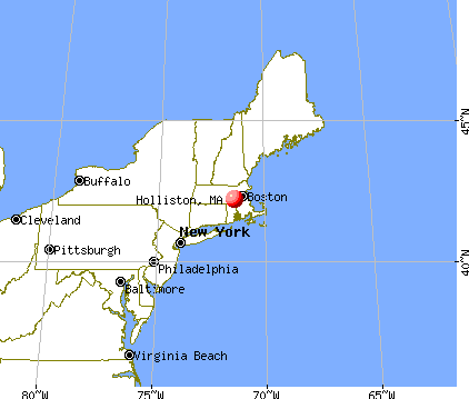
Nearest city with pop. 50,000+: Framingham, MA  (7.2 miles , pop. 66,910).
Nearest city with pop. 200,000+: Boston, MA (19.9 miles , pop. 589,141).
Nearest city with pop. 1,000,000+: Bronx, NY (156.9 miles , pop. 1,332,650).
Nearest cities:
Latitude: 42.20 N, Longitude: 71.44 W
Area codes: 508, 774

Holliston, Massachusetts accommodation & food services, waste management - Economy and Business Data
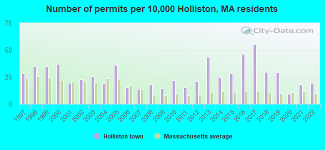
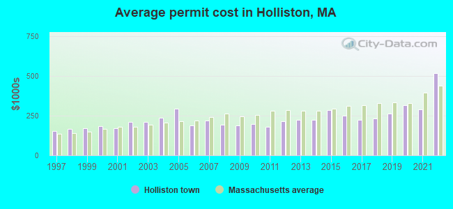
Single-family new house construction building permits:
- 2022: 27 buildings, average cost: $517,300
- 2021: 25 buildings, average cost: $290,600
- 2020: 13 buildings, average cost: $317,200
- 2019: 40 buildings, average cost: $261,700
- 2018: 41 buildings, average cost: $231,700
- 2017: 76 buildings, average cost: $221,800
- 2016: 64 buildings, average cost: $248,700
- 2015: 39 buildings, average cost: $285,200
- 2014: 34 buildings, average cost: $224,300
- 2013: 60 buildings, average cost: $224,900
- 2012: 29 buildings, average cost: $215,800
- 2011: 21 buildings, average cost: $177,700
- 2010: 30 buildings, average cost: $199,300
- 2009: 20 buildings, average cost: $188,900
- 2008: 25 buildings, average cost: $194,200
- 2007: 19 buildings, average cost: $220,500
- 2006: 21 buildings, average cost: $188,800
- 2005: 50 buildings, average cost: $293,600
- 2004: 26 buildings, average cost: $235,500
- 2003: 35 buildings, average cost: $211,900
- 2002: 31 buildings, average cost: $210,200
- 2001: 27 buildings, average cost: $172,600
- 2000: 51 buildings, average cost: $185,700
- 1999: 48 buildings, average cost: $168,900
- 1998: 48 buildings, average cost: $165,700
- 1997: 39 buildings, average cost: $152,500
| Here: | 3.3% |
| Massachusetts: | 3.5% |
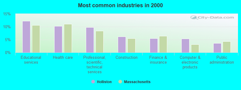
- Educational services (12.2%)
- Health care (10.3%)
- Professional, scientific, technical services (9.7%)
- Construction (6.1%)
- Finance & insurance (5.4%)
- Computer & electronic products (5.3%)
- Public administration (3.6%)
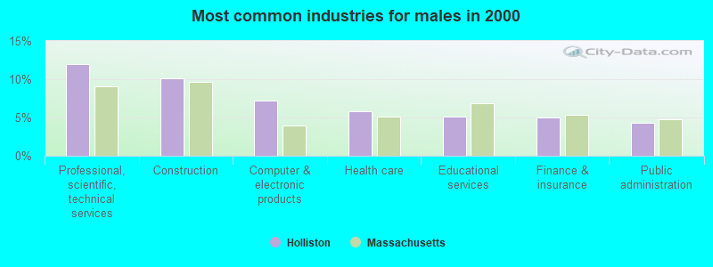
- Professional, scientific, technical services (11.9%)
- Construction (10.2%)
- Computer & electronic products (7.2%)
- Health care (5.8%)
- Educational services (5.2%)
- Finance & insurance (5.0%)
- Public administration (4.4%)
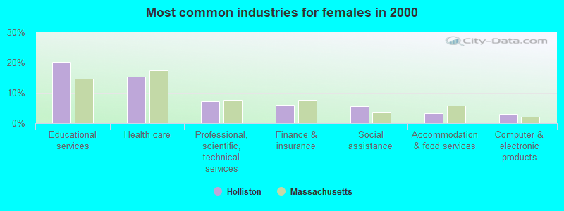
- Educational services (20.3%)
- Health care (15.4%)
- Professional, scientific, technical services (7.2%)
- Finance & insurance (6.0%)
- Social assistance (5.5%)
- Accommodation & food services (3.3%)
- Computer & electronic products (3.1%)
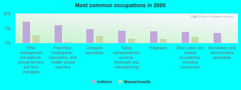
- Other management occupations, except farmers and farm managers (7.5%)
- Preschool, kindergarten, elementary, and middle school teachers (6.2%)
- Computer specialists (4.9%)
- Sales representatives, services, wholesale and manufacturing (4.4%)
- Engineers (4.2%)
- Other sales and related occupations, including supervisors (3.9%)
- Secretaries and administrative assistants (3.5%)
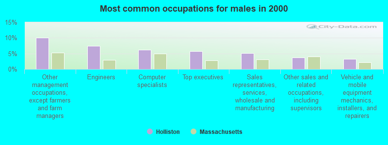
- Other management occupations, except farmers and farm managers (10.1%)
- Engineers (7.4%)
- Computer specialists (6.2%)
- Top executives (5.8%)
- Sales representatives, services, wholesale and manufacturing (5.1%)
- Other sales and related occupations, including supervisors (3.8%)
- Vehicle and mobile equipment mechanics, installers, and repairers (3.3%)
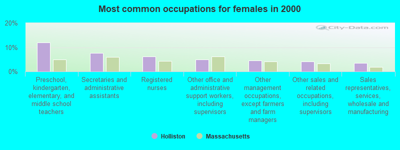
- Preschool, kindergarten, elementary, and middle school teachers (11.9%)
- Secretaries and administrative assistants (7.6%)
- Registered nurses (6.1%)
- Other office and administrative support workers, including supervisors (5.0%)
- Other management occupations, except farmers and farm managers (4.5%)
- Other sales and related occupations, including supervisors (4.1%)
- Sales representatives, services, wholesale and manufacturing (3.5%)
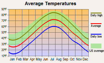
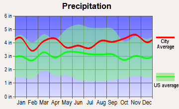
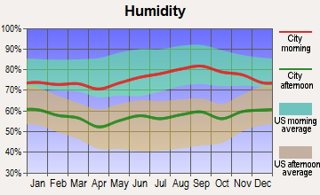
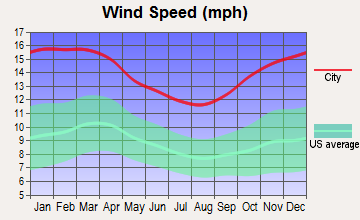
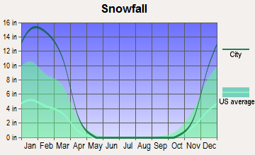
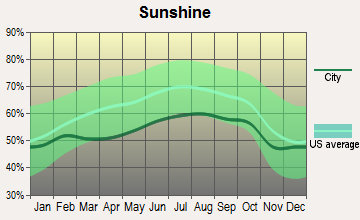
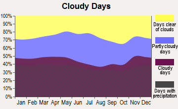
Average climate in Holliston, Massachusetts
Based on data reported by over 4,000 weather stations
(lower is better)
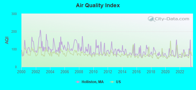
Air Quality Index (AQI) level in 2022 was 70.2. This is about average.
| City: | 70.2 |
| U.S.: | 72.6 |
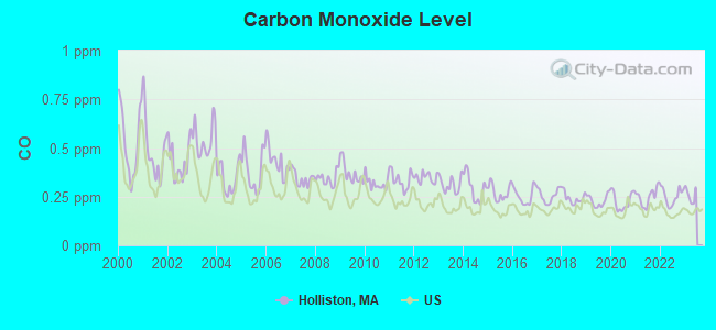
Carbon Monoxide (CO) [ppm] level in 2022 was 0.252. This is about average. Closest monitor was 16.1 miles away from the city center.
| City: | 0.252 |
| U.S.: | 0.251 |
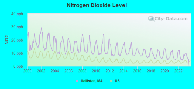
Nitrogen Dioxide (NO2) [ppb] level in 2022 was 7.61. This is significantly worse than average. Closest monitor was 5.4 miles away from the city center.
| City: | 7.61 |
| U.S.: | 5.11 |
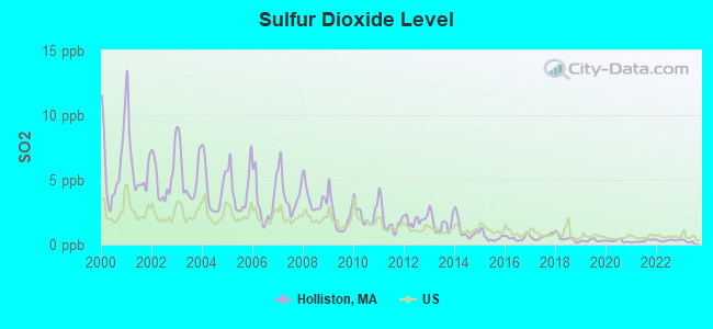
Sulfur Dioxide (SO2) [ppb] level in 2022 was 0.322. This is significantly better than average. Closest monitor was 3.7 miles away from the city center.
| City: | 0.322 |
| U.S.: | 1.515 |
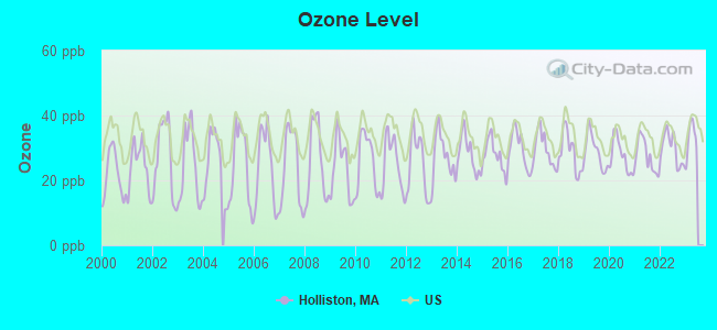
Ozone [ppb] level in 2022 was 29.7. This is about average. Closest monitor was 3.7 miles away from the city center.
| City: | 29.7 |
| U.S.: | 33.3 |
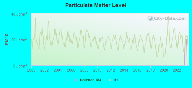
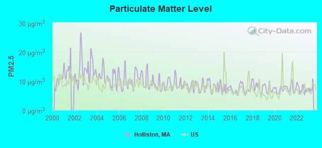
Particulate Matter (PM2.5) [µg/m3] level in 2022 was 7.17. This is about average. Closest monitor was 15.2 miles away from the city center.
| City: | 7.17 |
| U.S.: | 8.11 |
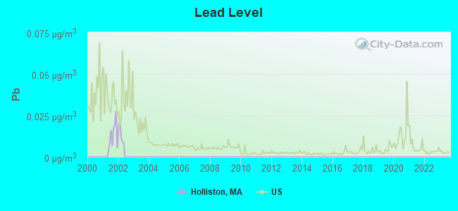
Lead (Pb) [µg/m3] level in 2001 was 0.0129. This is worse than average. Closest monitor was 19.0 miles away from the city center.
| City: | 0.0129 |
| U.S.: | 0.0093 |
Tornado activity:
Holliston-area historical tornado activity is near Massachusetts state average. It is 34% smaller than the overall U.S. average.
On 6/9/1953, a category F4 (max. wind speeds 207-260 mph) tornado 8.3 miles away from the Holliston town center killed 90 people and injured 1228 people and caused between $50,000,000 and $500,000,000 in damages.
On 6/9/1953, a category F3 (max. wind speeds 158-206 mph) tornado 15.8 miles away from the town center injured 17 people and caused between $500,000 and $5,000,000 in damages.
Earthquake activity:
Holliston-area historical earthquake activity is significantly above Massachusetts state average. It is 73% smaller than the overall U.S. average.On 10/7/1983 at 10:18:46, a magnitude 5.3 (5.1 MB, 5.3 LG, 5.1 ML, Class: Moderate, Intensity: VI - VII) earthquake occurred 190.5 miles away from the city center
On 4/20/2002 at 10:50:47, a magnitude 5.3 (5.3 ML, Depth: 3.0 mi) earthquake occurred 196.4 miles away from the city center
On 1/19/1982 at 00:14:42, a magnitude 4.7 (4.5 MB, 4.7 MD, 4.5 LG, Class: Light, Intensity: IV - V) earthquake occurred 90.6 miles away from the city center
On 4/20/2002 at 10:50:47, a magnitude 5.2 (5.2 MB, 4.2 MS, 5.2 MW, 5.0 MW) earthquake occurred 195.6 miles away from Holliston center
On 10/16/2012 at 23:12:25, a magnitude 4.7 (4.7 ML, Depth: 10.0 mi) earthquake occurred 104.7 miles away from Holliston center
On 8/22/1992 at 12:20:32, a magnitude 4.8 (4.8 MB, 3.8 MS, 4.7 LG, Depth: 6.2 mi) earthquake occurred 221.6 miles away from the city center
Magnitude types: regional Lg-wave magnitude (LG), body-wave magnitude (MB), duration magnitude (MD), local magnitude (ML), surface-wave magnitude (MS), moment magnitude (MW)
Natural disasters:
The number of natural disasters in Middlesex County (31) is a lot greater than the US average (15).Major Disasters (Presidential) Declared: 17
Emergencies Declared: 14
Causes of natural disasters: Floods: 12, Storms: 9, Hurricanes: 6, Snowstorms: 6, Winter Storms: 5, Blizzards: 2, Snows: 2, Explosion: 1, Heavy Rain: 1, Snowfall: 1, Water Main Break: 1, Wind: 1 (Note: some incidents may be assigned to more than one category).

Main business address for: HARVARD BIOSCIENCE INC (LABORATORY ANALYTICAL INSTRUMENTS).
Hospitals and medical centers in Holliston:
Other hospitals and medical centers near Holliston:
- MEDWAY COUNTRY MANOR SKILLED NURSING AND REHAB (Nursing Home, about 3 miles away; MEDWAY, MA)
- ASHLAND MANOR NH (Nursing Home, about 5 miles away; ASHLAND, MA)
- VNA AND HOSPICE OF GREATER MILFORD (Home Health Center, about 5 miles away; MILFORD, MA)
- BETHANY SKILLED NURSING FACILITY (Nursing Home, about 5 miles away; FRAMINGHAM, MA)
- MILFORD CARE AND REHABILITATION CENTER (Nursing Home, about 5 miles away; MILFORD, MA)
- BLAIRE HOUSE OF MILFORD (Nursing Home, about 6 miles away; MILFORD, MA)
- MEDFIELD STATE HOSPITAL (Hospital, about 6 miles away; MEDFIELD, MA)
Heliports located in Holliston:
See details about Heliports located in Holliston, MAAmtrak stations near Holliston:
- 6 miles: FRAMINGHAM (443 WAVERLY ST.) . Services: public payphones, snack bar, paid short-term parking, taxi stand, public transit connection.
- 15 miles: ROUTE 128 (WESTWOOD, UNIVERSITY AVE. & RTE. 128) . Services: ticket office, enclosed waiting area, public restrooms, public payphones, vending machines, paid short-term parking, taxi stand, public transit connection.
- 19 miles: WORCESTER (WORCHESTER, 45 SHREWSBURY ST.) . Services: ticket office, fully wheelchair accessible, enclosed waiting area, public restrooms, public payphones, vending machines, free short-term parking, free long-term parking, call for taxi service, public transit connection.
Colleges/universities with over 2000 students nearest to Holliston:
- Framingham State University (about 8 miles; Framingham, MA; Full-time enrollment: 5,743)
- Wellesley College (about 10 miles; Wellesley, MA; FT enrollment: 2,658)
- Babson College (about 12 miles; Wellesley, MA; FT enrollment: 3,230)
- Massachusetts Bay Community College (about 13 miles; Wellesley Hills, MA; FT enrollment: 3,636)
- Brandeis University (about 15 miles; Waltham, MA; FT enrollment: 6,966)
- Boston College (about 17 miles; Chestnut Hill, MA; FT enrollment: 12,070)
- Curry College (about 17 miles; Milton, MA; FT enrollment: 2,586)
Public high school in Holliston:
- HOLLISTON HIGH (Students: 899, Location: 370 HOLLIS STREET, Grades: 9-12)
Public elementary/middle schools in Holliston:
- ROBERT H. ADAMS MIDDLE SCHOOL (Students: 716, Location: 323 WOODLAND STREET, Grades: 6-8)
- PLACENTINO ELEMENTARY (Students: 706, Location: 235 WOODLAND STREET, Grades: PK-2)
- MILLER SCHOOL (Students: 618, Location: 235 WOODLAND STREET, Grades: 3-5)
Library in Holliston:
Points of interest:
Notable locations in Holliston: Arcadian Farms (A), Highland Farm (B), New Englander Industrial Park (C), MetroWest Emergency Medical Services (D), Holliston Fire Department Station 4B (E), Holliston Fire Department Station 3 (F), Holliston Fire Department Station 4 (G), Holliston Fire Department Station 2 (H), Holliston Fire Department Station 1 Headquarters (I), Holliston High School Library (J), Holliston Public Library (K). Display/hide their locations on the map
Shopping Center: Russells Shopping Center (1). Display/hide its location on the map
Main business address in Holliston: HARVARD BIOSCIENCE INC (A). Display/hide its location on the map
Churches in Holliston include: Saint Michaels Church (A), Saint Marys Church (B), First Congregational Church (C), First Baptist Church (D), Christ the King Lutheran Church (E). Display/hide their locations on the map
Cemeteries: Center Cemetery (1), Lake Grove Cemetery (2), Saint Marys Cemetery (3), Indian Cemetery (4), Holliston Center Cemetery (5), Bragg Cemetery (6), Lincoln Cemetery (7). Display/hide their locations on the map
Lakes, reservoirs, and swamps: Lake Winthrop (A), Weston Pond (B), Factory Pond (C), Houghton Pond (D), Linden Pond (E), Dapping Brook Swamp (F), Bogastere Swamp (G), Cedar Swamp (H). Display/hide their locations on the map
Streams, rivers, and creeks: Deer Brook (A), Beaver Brook (B), Dirty Meadow Brook (C), Dopping Brook (D), Jar Brook (E), Winthrop Canal (F), Vine Brook (G). Display/hide their locations on the map
Park in Holliston: Stoddard Park (1). Display/hide its location on the map
Tourist attraction: Boston International Inc (Cultural Attractions- Events- & Facilities; 89 October Hill Road) (1). Display/hide its approximate location on the map
Hotel: Erich Associates Inc. (36 Birchwood Road) (1). Display/hide its approximate location on the map
Birthplace of: Adam Green (filmmaker) - Film director, Greg Mauldin - Ice hockey player, Bob Bicknell - Football coach, John D'earth - Jazz trumpeter, John Sencio - Television personality.
Drinking water stations with addresses in Holliston and their reported violations in the past:
HOLLISTON WATER DEPARTMENT (Population served: 14,917, Groundwater):Past health violations:BLUEBERRY RIDGE MH VILLAGE (Serves ME, Population served: 128, Groundwater):Past monitoring violations:
- MCL, Monthly (TCR) - In FEB-2014, Contaminant: Coliform. Follow-up actions: St AO (w/o penalty) issued (MAY-15-2014)
- MCL, Monthly (TCR) - In JUL-2013, Contaminant: Coliform. Follow-up actions: St AO (w/o penalty) issued (OCT-16-2013)
- MCL, Acute (TCR) - In SEP-2011, Contaminant: Coliform. Follow-up actions: St AO (w/o penalty) issued (DEC-09-2011), St Compliance achieved (DEC-09-2011)
- MCL, Monthly (TCR) - In SEP-2011, Contaminant: Coliform. Follow-up actions: St AO (w/o penalty) issued (DEC-09-2011), St Compliance achieved (DEC-09-2011)
- Monitoring and Reporting (DBP) - Between JUL-2013 and SEP-2013, Contaminant: TTHM. Follow-up actions: St AO (w/o penalty) issued (NOV-26-2013)
- Monitoring and Reporting (DBP) - Between JUL-2013 and SEP-2013, Contaminant: Total Haloacetic Acids (HAA5). Follow-up actions: St AO (w/o penalty) issued (NOV-26-2013)
- Monitoring and Reporting (DBP) - Between JUL-2013 and SEP-2013, Contaminant: Chlorine. Follow-up actions: St AO (w/o penalty) issued (NOV-26-2013)
- Follow-up Or Routine LCR Tap M/R - In JUL-01-2011, Contaminant: Lead and Copper Rule. Follow-up actions: St AO (w/o penalty) issued (MAR-07-2012), St Compliance achieved (SEP-20-2012)
- Monitoring and Reporting (DBP) - Between JUL-2010 and SEP-2010, Contaminant: Chlorine. Follow-up actions: St AO (w/o penalty) issued (NOV-12-2010), St Compliance achieved (NOV-12-2010)
- 54 regular monitoring violations
- 2 other older monitoring violations
Past health violations:PINEWOOD MOBILE HOME COURT INC (Serves ME, Population served: 100, Groundwater):Past monitoring violations:
- MCL, Average - Between JAN-2007 and MAR-2007, Contaminant: Arsenic. Follow-up actions: St Public Notif requested (FEB-12-2007), St Violation/Reminder Notice (FEB-12-2007), St Public Notif received (MAR-05-2007), St Compliance achieved (AUG-21-2008)
- MCL, Average - Between JAN-2006 and MAR-2006, Contaminant: Arsenic. Follow-up actions: St Public Notif requested (JUN-14-2006), St Violation/Reminder Notice (JUN-14-2006), St Public Notif received (2 times from JUL-18-2006 to JUL-18-2006), St Compliance achieved (AUG-21-2008)
- Follow-up Or Routine LCR Tap M/R - In OCT-01-2011, Contaminant: Lead and Copper Rule. Follow-up actions: St Public Notif requested (DEC-09-2011), St Formal NOV issued (DEC-09-2011), St Compliance achieved (AUG-24-2012), St Public Notif received (OCT-29-2012)
- Follow-up Or Routine LCR Tap M/R - In OCT-01-2010, Contaminant: Lead and Copper Rule. Follow-up actions: St Public Notif requested (DEC-29-2010), St Formal NOV issued (DEC-29-2010), St Compliance achieved (AUG-24-2012), St Public Notif received (OCT-29-2012)
- Follow-up Or Routine LCR Tap M/R - In OCT-01-2007, Contaminant: Lead and Copper Rule. Follow-up actions: St Public Notif requested (MAY-05-2010), St Formal NOV issued (MAY-05-2010), St Compliance achieved (AUG-24-2012), St Public Notif received (OCT-29-2012)
- One routine major monitoring violation
- 2 regular monitoring violations
Past monitoring violations:
- One routine major monitoring violation
- 13 regular monitoring violations
| This town: | 2.7 people |
| Massachusetts: | 2.5 people |
| This town: | 77.7% |
| Whole state: | 63.0% |
| This town: | 3.8% |
| Whole state: | 7.0% |
Likely homosexual households (counted as self-reported same-sex unmarried-partner households)
- Lesbian couples: 0.5% of all households
- Gay men: 0.2% of all households
| This town: | 3.4% |
| Whole state: | 9.3% |
| This town: | 2.2% |
| Whole state: | 4.4% |
People in group quarters in Holliston in 2010:
- 27 people in nursing facilities/skilled-nursing facilities
- 4 people in group homes intended for adults
- 4 people in other noninstitutional facilities
6 people in religious group quarters in 2000
Banks with branches in Holliston (2011 data):
- TD Bank, National Association: Holliston Branch at 746 Washington Street, Rte. 126/16, branch established on 1977/09/10. Info updated 2010/10/04: Bank assets: $188,912.6 mil, Deposits: $153,149.8 mil, headquarters in Wilmington, DE, positive income, 1314 total offices, Holding Company: Toronto-Dominion Bank, The
- Sovereign Bank, National Association: Holliston Branch at 818 Washington Street, branch established on 1956/02/27. Info updated 2012/01/31: Bank assets: $78,146.9 mil, Deposits: $48,042.9 mil, headquarters in Wilmington, DE, positive income, Commercial Lending Specialization, 718 total offices, Holding Company: Banco Santander, S.A.
- Middlesex Savings Bank: Holliston Branch at 830 Washington Street, branch established on 1867/01/01. Info updated 2009/07/16: Bank assets: $4,034.8 mil, Deposits: $3,490.0 mil, headquarters in Natick, MA, positive income, Mortgage Lending Specialization, 33 total offices, Holding Company: Middlesex Bancorp Mhc
For population 15 years and over in Holliston:
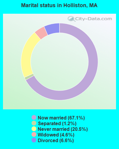
- Never married: 20.5%
- Now married: 67.1%
- Separated: 1.2%
- Widowed: 4.6%
- Divorced: 6.6%
For population 25 years and over in Holliston:
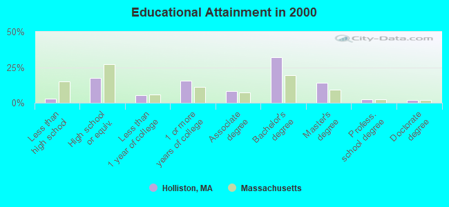
- High school or higher: 96.9%
- Bachelor's degree or higher: 50.8%
- Graduate or professional degree: 18.8%
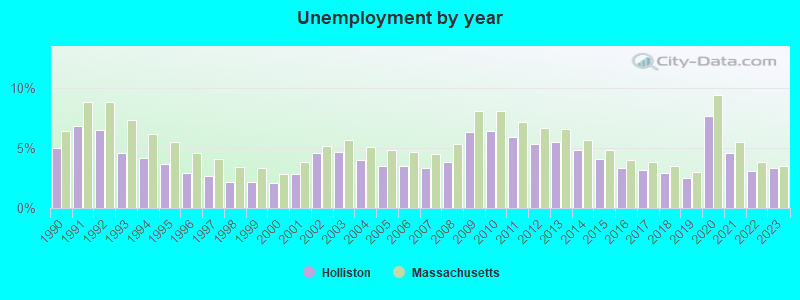
- Unemployed: 2.9%
- Mean travel time to work (commute): 32.2 minutes

| Here: | 9.3 |
| Massachusetts average: | 13.1 |


Graphs represent county-level data. Detailed 2008 Election Results
Religion statistics for Holliston, MA (based on Middlesex County data)


| Religion | Adherents | Congregations |
|---|---|---|
| Catholic | 718,209 | 107 |
| Mainline Protestant | 70,053 | 269 |
| Other | 68,480 | 199 |
| Evangelical Protestant | 41,270 | 304 |
| Orthodox | 23,641 | 28 |
| Black Protestant | 2,276 | 8 |
| None | 579,156 | - |
Food Environment Statistics:
| This county: | 1.71 / 10,000 pop. |
| Massachusetts: | 1.98 / 10,000 pop. |
| Middlesex County: | 0.03 / 10,000 pop. |
| State: | 0.05 / 10,000 pop. |
| Here: | 2.14 / 10,000 pop. |
| State: | 2.22 / 10,000 pop. |
| Here: | 1.38 / 10,000 pop. |
| Massachusetts: | 1.77 / 10,000 pop. |
| This county: | 7.84 / 10,000 pop. |
| Massachusetts: | 8.76 / 10,000 pop. |
| This county: | 7.8% |
| State: | 8.1% |
| This county: | 21.5% |
| Massachusetts: | 22.5% |
| Here: | 18.0% |
| State: | 16.5% |
6.91% of this county's 2021 resident taxpayers lived in other counties in 2020 ($102,955 average adjusted gross income)
| Here: | 6.91% |
| Massachusetts average: | 6.35% |
0.01% of residents moved from foreign countries ($137 average AGI)
Middlesex County: 0.01% Massachusetts average: 0.01%
Top counties from which taxpayers relocated into this county between 2020 and 2021:
| from Suffolk County, MA | |
| from Essex County, MA | |
| from Norfolk County, MA |
8.22% of this county's 2020 resident taxpayers moved to other counties in 2021 ($123,369 average adjusted gross income)
| Here: | 8.22% |
| Massachusetts average: | 7.18% |
0.01% of residents moved to foreign countries ($124 average AGI)
Middlesex County: 0.01% Massachusetts average: 0.02%
Top counties to which taxpayers relocated from this county between 2020 and 2021:
| to Suffolk County, MA | |
| to Essex County, MA | |
| to Worcester County, MA |
| Businesses in Holliston, MA | ||||
| Name | Count | Name | Count | |
|---|---|---|---|---|
| CVS | 1 | Subway | 1 | |
| Circle K | 1 | True Value | 1 | |
| Dunkin Donuts | 1 | U-Haul | 1 | |
| FedEx | 6 | UPS | 4 | |
Strongest AM radio stations in Holliston:
- WAMG (890 AM; 25 kW; DEDHAM, MA; Owner: MEGA COMMUNICATIONS OF DEDHAM LICENSEE, LLC)
- WKOX (1200 AM; 50 kW; FRAMINGHAM, MA; Owner: CAPSTAR TX LIMITED PARTNERSHIP)
- WBIX (1060 AM; 40 kW; NATICK, MA; Owner: LANGER BROADCASTING CORPORATION)
- WEEI (850 AM; 50 kW; BOSTON, MA; Owner: ENTERCOM BOSTON LICENSE, LLC)
- WSRO (650 AM; 2 kW; ASHLAND, MA; Owner: LANGER BROADCASTING GROUP, LLC)
- WALE (990 AM; 50 kW; GREENVILLE, RI; Owner: NORTH AMERICAN BROADCASTING CO., INC.)
- WRKO (680 AM; 50 kW; BOSTON, MA; Owner: ENTERCOM BOSTON LICENSE, LLC)
- WWZN (1510 AM; 50 kW; BOSTON, MA; Owner: ROSE CITY RADIO CORPORATION)
- WRCA (1330 AM; 25 kW; WALTHAM, MA; Owner: WRCA LICENSE, LLC)
- WCRN (830 AM; 50 kW; WORCESTER, MA; Owner: CARTER BROADCASTING CORPORATION)
- WUNR (1600 AM; 20 kW; BROOKLINE, MA; Owner: CHAMPION BROADCASTING SYSTEMS, INC.)
- WBZ (1030 AM; 50 kW; BOSTON, MA; Owner: INFINITY BROADCASTING OPERATIONS, INC.)
- WNTN (1550 AM; 10 kW; NEWTON, MA; Owner: COLT COMMUNICATIONS, LLC)
Strongest FM radio stations in Holliston:
- WHHB (99.9 FM; HOLLISTON, MA; Owner: HOLLISTON HIGH SCHOOL)
- WBMX (98.5 FM; BOSTON, MA; Owner: INFINITY RADIO OPERATIONS INC.)
- WJMN (94.5 FM; BOSTON, MA; Owner: AMFM RADIO LICENSES, L.L.C.)
- WCRB (102.5 FM; WALTHAM, MA; Owner: CHARLES RIVER BROADCASTING WCRB LICE)
- WTKK (96.9 FM; BOSTON, MA; Owner: GREATER BOSTON RADIO, INC.)
- WROR-FM (105.7 FM; FRAMINGHAM, MA; Owner: GREATER BOSTON RADIO, INC.)
- WBOS (92.9 FM; BROOKLINE, MA; Owner: GREATER BOSTON RADIO, INC.)
- WGBH (89.7 FM; BOSTON, MA; Owner: WGBH EDUCATIONAL FOUNDATION)
- WBUR-FM (90.9 FM; BOSTON, MA; Owner: TRUSTEES OF BOSTON UNIVERSITY)
- WODS (103.3 FM; BOSTON, MA; Owner: INFINITY BROADCASTING OPERATIONS, INC.)
- WXKS-FM (107.9 FM; MEDFORD, MA; Owner: AMFM RADIO LICENSES, L.L.C.)
- WMJX (106.7 FM; BOSTON, MA; Owner: GREATER BOSTON RADIO, INC.)
- WAAF (107.3 FM; WORCESTER, MA; Owner: ENTERCOM BOSTON LICENSE, LLC)
- WWBB (101.5 FM; PROVIDENCE, RI; Owner: CLEAR CHANNEL BROADCASTING LICENSES, INC.)
- WBCN (104.1 FM; BOSTON, MA; Owner: HEMISPHERE BROADCASTING CORPORATION)
- WZLX (100.7 FM; BOSTON, MA; Owner: INFINITY BROADCASTING CORPORATION OF BOSTON)
- W267AI (101.3 FM; BOSTON, MA; Owner: MCC BROADCASTING COMPANY, INC.)
- WERS (88.9 FM; BOSTON, MA; Owner: EMERSON COLLEGE)
- WWKX (106.3 FM; WOONSOCKET, RI; Owner: AAA ENTERTAINMENT LICENSING LLC)
- WGAO (88.3 FM; FRANKLIN, MA; Owner: DEAN COLLEGE)
TV broadcast stations around Holliston:
- WCVB-TV (Channel 5; BOSTON, MA; Owner: WCVB HEARST-ARGYLE TV, INC.)
- WGBH-TV (Channel 2; BOSTON, MA; Owner: WGBH EDUCATIONAL FOUNDATION)
- WMFP (Channel 62; LAWRENCE, MA; Owner: WSAH LICENSE, INC.)
- WBZ-TV (Channel 4; BOSTON, MA; Owner: VIACOM INC.)
- WGBX-TV (Channel 44; BOSTON, MA; Owner: WGBH EDUCATIONAL FOUNDATION)
- WHDH-TV (Channel 7; BOSTON, MA; Owner: WHDH-TV)
- WSBK-TV (Channel 38; BOSTON, MA; Owner: VIACOM INC.)
- WLVI-TV (Channel 56; CAMBRIDGE, MA; Owner: WLVI, INC.)
- WUTF (Channel 66; MARLBOROUGH, MA; Owner: TELEFUTURA BOSTON LLC)
- WFXT (Channel 25; BOSTON, MA; Owner: FOX TELEVISION STATIONS INC.)
- WUNI (Channel 27; WORCESTER, MA; Owner: ENTRAVISION HOLDINGS, LLC)
- W40BO (Channel 40; BOSTON, MA; Owner: PAXSON COMMUNICATIONS LPTV, INC.)
- WBPX (Channel 68; BOSTON, MA; Owner: PAXSON BOSTON-68 LICENSE, INC.)
- WWDP (Channel 46; NORWELL, MA; Owner: NORWELL TELEVISION, LLC)
- WTMU-LP (Channel 32; BOSTON, MA; Owner: ZGS BOSTON, INC.)
- WNAC-TV (Channel 64; PROVIDENCE, RI; Owner: WNAC, LLC)
- WCEA-LP (Channel 58; BOSTON, MA; Owner: CHANNEL 19 TV CORPORATION)
- WPRI-TV (Channel 12; PROVIDENCE, RI; Owner: TVL BROADCASTING OF RHODE ISLAND, LLC)
- WLNE-TV (Channel 6; NEW BEDFORD, MA; Owner: FREEDOM BROADCASTING OF SOUTHERN NEW ENGLAND, INC.)
- WJAR (Channel 10; PROVIDENCE, RI; Owner: OUTLET BROADCASTING, INC.)
- WSBE-TV (Channel 36; PROVIDENCE, RI; Owner: RHODE ISLAND PUBLIC TELECOM. AUTHORITY)
- WPXQ (Channel 69; BLOCK ISLAND, RI; Owner: OCEAN STATE TELEVISION, L.L.C.)
- WYDN (Channel 48; WORCESTER, MA; Owner: EDUCATIONAL PUBLIC TV CORPORATION)
- WFXZ-CA (Channel 24; BOSTON, MA; Owner: BOSTON BROADCASTING CORP.)
- WRIW-LP (Channel 50; PROVIDENCE, RI; Owner: ZGS PROVIDENCE, INC.)
FCC Registered Antenna Towers:
14 (See the full list of FCC Registered Antenna Towers in Holliston)FCC Registered Broadcast Land Mobile Towers:
8 (See the full list of FCC Registered Broadcast Land Mobile Towers in Holliston, MA)FCC Registered Microwave Towers:
8 (See the full list of FCC Registered Microwave Towers in this town)FCC Registered Amateur Radio Licenses:
129 (See the full list of FCC Registered Amateur Radio Licenses in Holliston)FAA Registered Aircraft:
7- Aircraft: BEECH C23 (Category: Land, Seats: 4, Weight: Up to 12,499 Pounds, Speed: 116 mph), Engine: LYCOMING O&VO-360 SER (180 HP) (Reciprocating)
N-Number: 23851, N23851, N-23851, Serial Number: M-2006, Year manufactured: 1978, Airworthiness Date: 01/27/1978, Certificate Issue Date: 09/04/2008
Registrant (Individual): James M Hilliard, 109 Arch St, Holliston, MA 01746 - Aircraft: UNMANNED AERIAL SYSTEMS DEVEL CARBONCORE 1 (Category: Land, Engines: 8), Engine: Electric
N-Number: 243JM, N243JM, N-243JM, Serial Number: MJJ201401, Certificate Issue Date: 11/03/2015
Registrant (Corporation): Unmanned Aerial Systems Development Inc, 24 Water St, Holliston, MA 01746 - Aircraft: CIRRUS DESIGN CORP SR22 (Category: Land, Seats: 4, Weight: Up to 12,499 Pounds), Engine: CONT MOTOR IO-550-N (310 HP) (Reciprocating)
N-Number: 459J, N459J, N-459J, Serial Number: 2517, Year manufactured: 2007, Airworthiness Date: 05/21/2007, Certificate Issue Date: 04/17/2013
Registrant (Individual): Jong Michael L De, 60 Bald Hill Rd, Holliston, MA 01746 - Aircraft: CESSNA 177RG (Category: Land, Seats: 4, Weight: Up to 12,499 Pounds, Speed: 120 mph), Engine: LYCOMING IO-360-A1B6D (200 HP) (Reciprocating)
N-Number: 52894, N52894, N-52894, Serial Number: 177RG1302, Year manufactured: 1977, Airworthiness Date: 01/09/1978, Certificate Issue Date: 03/22/2006
Registrant (Individual): Michael J Craren, 107 Juniper Rd, Holliston, MA 01746 - Aircraft: 3D ROBOTICS SOLO (Category: Land, Engines: 4), Engine: Electric
N-Number: 607NU, N607NU, N-607NU, Serial Number: OC3DRSA1506001616, Certificate Issue Date: 10/23/2015
Registrant (Corporation): Unmanned Aerial Systems Development Inc, 24 Water St Ste 3-19, Holliston, MA 01746 - Aircraft: AIR CREATION TANARG (Category: Land, Seats: 2, Weight: Up to 12,499 Pounds), Engine: ROTAX 912UL SERIES (80 HP) (4 Cycle)
N-Number: 665TH, N665TH, N-665TH, Serial Number: T06073, Year manufactured: 2006, Airworthiness Date: 01/30/2008, Certificate Issue Date: 06/26/2014
Registrant (Individual): John W Amann, 11 Timber Ledge Dr, Holliston, MA 01746 - Aircraft: MOONEY M20J (Category: Land, Seats: 4, Weight: Up to 12,499 Pounds, Speed: 126 mph), Engine: LYCOMING I0360 SER A&C (200 HP) (Reciprocating)
N-Number: 93201, N93201, N-93201, Serial Number: 24-1618, Year manufactured: 1987, Airworthiness Date: 05/20/1993, Certificate Issue Date: 02/09/2011
Registrant (Individual): Debnath Bodhisattva, 12 Willowgate Rise, Holliston, MA 01746
2002 - 2018 National Fire Incident Reporting System (NFIRS) incidents
- Fire incident types reported to NFIRS in Holliston, MA
- 8881.5%Structure Fires
- 1312.0%Mobile Property/Vehicle Fires
- 43.7%Outside Fires
- 32.8%Other
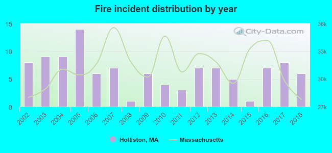 According to the data from the years 2002 - 2018 the average number of fire incidents per year is 6. The highest number of fire incidents - 14 took place in 2005, and the least - 1 in 2008. The data has a dropping trend.
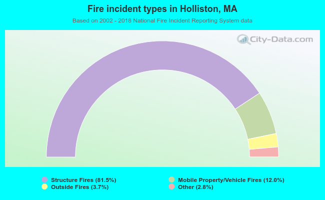 When looking into fire subcategories, the most reports belonged to: Structure Fires (81.5%), and Mobile Property/Vehicle Fires (12.0%).
- 54.0%Utility gas
- 38.9%Fuel oil, kerosene, etc.
- 4.5%Electricity
- 1.4%Bottled, tank, or LP gas
- 0.7%Wood
- 0.4%Coal or coke
- 0.2%Other fuel
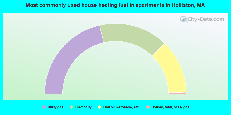
- 42.8%Utility gas
- 31.6%Electricity
- 24.8%Fuel oil, kerosene, etc.
- 0.8%Bottled, tank, or LP gas
Holliston compared to Massachusetts state average:
- Median household income above state average.
- Unemployed percentage significantly below state average.
- Black race population percentage significantly below state average.
- Hispanic race population percentage significantly below state average.
- Foreign-born population percentage significantly below state average.
- Renting percentage significantly below state average.
- Length of stay since moving in significantly above state average.
- Number of rooms per house significantly below state average.
- House age significantly below state average.
- Percentage of population with a bachelor's degree or higher above state average.
Holliston on our top lists:
- #6 on the list of "Top 101 cities with largest percentage of females in occupations: preschool, kindergarten, elementary and middle school teachers (population 5,000+)"
- #13 on the list of "Top 101 cities with largest percentage of males in industries: data processing, libraries, and other information services (population 5,000+)"
- #36 on the list of "Top 101 cities with largest percentage of males in occupations: mathematical science occupations (population 5,000+)"
- #37 on the list of "Top 101 cities with largest percentage of males in occupations: engineers (population 5,000+)"
- #37 on the list of "Top 101 cities with largest percentage of females in industries: recyclable material merchant wholesalers (population 5,000+)"
- #40 on the list of "Top 101 cities with largest percentage of males in occupations: architects, surveyors, and cartographers (population 5,000+)"
- #40 on the list of "Top 101 cities with largest percentage of females in occupations: rail and water transportation workers (population 5,000+)"
- #57 on the list of "Top 101 cities with largest percentage of females in industries: petroleum and coal products (population 5,000+)"
- #60 on the list of "Top 101 cities with largest percentage of males in industries: publishing, and motion picture and sound recording industries (population 5,000+)"
- #64 on the list of "Top 101 cities with largest percentage of females in occupations: social scientists and related workers (population 5,000+)"
- #67 on the list of "Top 101 cities with largest percentage of males in industries: professional and commercial equipment and supplies merchant wholesalers (population 5,000+)"
- #71 on the list of "Top 101 cities with largest percentage of females in industries: publishing, and motion picture and sound recording industries (population 5,000+)"
- #74 on the list of "Top 101 cities with largest percentage of males in industries: computer and electronic products (population 5,000+)"
- #74 on the list of "Top 101 cities with largest percentage of females in industries: furniture and related product manufacturing (population 5,000+)"
- #78 on the list of "Top 101 cities with largest percentage of females in industries: office supplies and stationery stores (population 5,000+)"
- #4 on the list of "Top 101 counties with the most Orthodox adherents"
- #7 on the list of "Top 101 counties with the most Catholic adherents"
- #7 on the list of "Top 101 counties with the most Mainline Protestant congregations"
- #7 on the list of "Top 101 counties with the most Orthodox congregations"
- #8 on the list of "Top 101 counties with the lowest percentage of residents that keep firearms around their homes"

|
|
Total of 733 patent applications in 2008-2024.