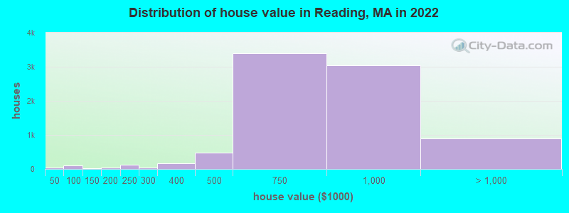
Estimated median house or condo value in 2022: $752,986 (it was $268,000 in 2000)
Reading:
$752,986
MA:
$534,700
Mean prices in 2022:all housing units: $773,743; detached houses: $810,965; townhouses or other attached units: $919,529; in 2-unit structures: $657,090; in 3-to-4-unit structures: $569,134; in 5-or-more-unit structures: $466,048
Median gross rent in 2022: $1,644.
March 2022 cost of living index in Reading: 134.6 (high, U.S. average is 100)
Percentage of residents living in poverty in 2022: 3.5%
(3.5% for White Non-Hispanic residents, 10.6% for Hispanic or Latino residents, 41.3% for other race residents, 1.6% for two or more races residents)
According to our research of Massachusetts and other state lists, there were 2 registered sex offenders living in Reading, Massachusetts as of April 28, 2024. The ratio of all residents to sex offenders in Reading is 12,925 to 1. The ratio of registered sex offenders to all residents in this city is much lower than the state average.
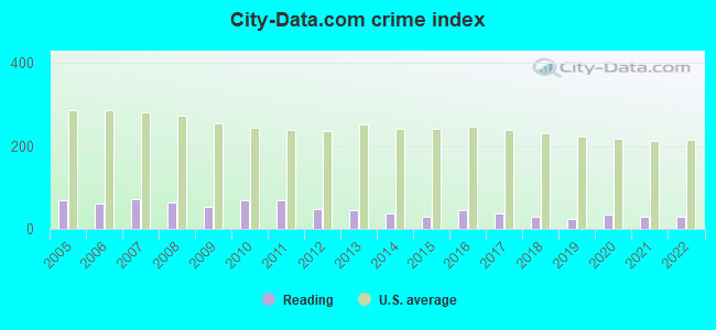
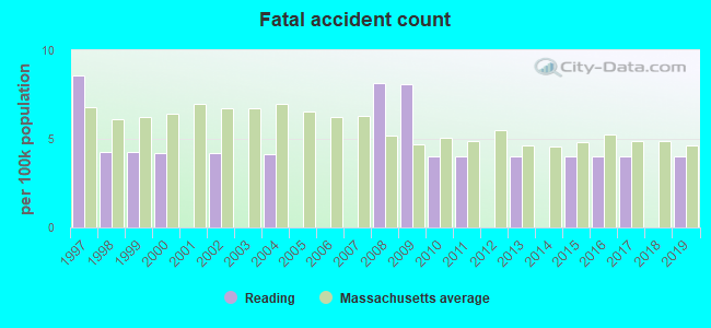
Crime rates in Reading by year
Type
2009
2010
2011
2012
2013
2014
2015
2016
2017
2018
2019
2020
2021
2022
Murders (per 100,000)
0 (0.0)
0 (0.0)
0 (0.0)
0 (0.0)
0 (0.0)
0 (0.0)
0 (0.0)
0 (0.0)
0 (0.0)
0 (0.0)
0 (0.0)
0 (0.0)
0 (0.0)
0 (0.0)
Rapes (per 100,000)
1 (4.3)
0 (0.0)
1 (4.0)
0 (0.0)
0 (0.0)
1 (3.9)
0 (0.0)
1 (3.9)
2 (7.7)
0 (0.0)
0 (0.0)
2 (7.9)
0 (0.0)
0 (0.0)
Robberies (per 100,000)
1 (4.3)
8 (32.3)
2 (8.0)
6 (23.8)
3 (11.8)
0 (0.0)
1 (3.9)
5 (19.4)
1 (3.8)
2 (7.6)
0 (0.0)
0 (0.0)
1 (3.9)
0 (0.0)
Assaults (per 100,000)
9 (38.5)
5 (20.2)
8 (32.1)
4 (15.9)
7 (27.6)
5 (19.6)
5 (19.5)
5 (19.4)
4 (15.4)
3 (11.4)
3 (11.9)
9 (35.4)
8 (30.9)
4 (16.0)
Burglaries (per 100,000)
29 (123.9)
90 (363.7)
105 (421.7)
44 (174.4)
51 (200.8)
40 (156.6)
26 (101.1)
34 (131.9)
26 (99.9)
24 (91.3)
15 (59.3)
12 (47.2)
10 (38.6)
23 (91.9)
Thefts (per 100,000)
165 (705.2)
156 (630.4)
158 (634.6)
136 (539.2)
122 (480.4)
116 (454.2)
105 (408.5)
136 (527.6)
129 (495.5)
112 (426.0)
94 (371.5)
86 (338.4)
108 (417.0)
123 (491.6)
Auto thefts (per 100,000)
9 (38.5)
10 (40.4)
7 (28.1)
9 (35.7)
11 (43.3)
6 (23.5)
4 (15.6)
6 (23.3)
3 (11.5)
8 (30.4)
7 (27.7)
11 (43.3)
3 (11.6)
1 (4.0)
Arson (per 100,000)
0 (0.0)
0 (0.0)
0 (0.0)
0 (0.0)
0 (0.0)
1 (3.9)
0 (0.0)
0 (0.0)
0 (0.0)
1 (3.8)
0 (0.0)
0 (0.0)
2 (7.7)
0 (0.0)
City-Data.com crime index
52.4
67.6
69.2
46.9
45.8
38.1
29.7
45.0
38.1
30.4
23.6
33.7
27.6
29.6
The City-Data.com crime index weighs serious crimes and violent crimes more heavily. Higher means more crime, U.S. average is 246.1. It adjusts for the number of visitors and daily workers commuting into cities.
Latest news from Reading, MA collected exclusively by city-data.com from local newspapers, TV, and radio stations
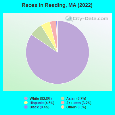
Ancestries: Irish (25.6%), Italian (20.7%), English (7.1%), American (6.8%), European (2.5%), French Canadian (2.5%).
Current Local Time: EST time zone
Incorporated in 1644
Elevation: 129 feet
Land area: 9.93 square miles.
Population density: 2,493 people per square mile (low).
2,239 residents are foreign born (4.5% Asia, 2.0% Europe, 1.1% Latin America).
This place:
8.8%
Massachusetts:
17.6%
Median real estate property taxes paid for housing units with mortgages in 2022: $8,875 (1.1%) Median real estate property taxes paid for housing units with no mortgage in 2022: $8,538 (1.2%)
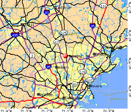
Nearest city with pop. 50,000+: Malden, MA (7.2 miles , pop. 56,340).
Nearest city with pop. 200,000+: Boston, MA (14.2 miles , pop. 589,141).
Nearest city with pop. 1,000,000+: Bronx, NY (184.0 miles , pop. 1,332,650).
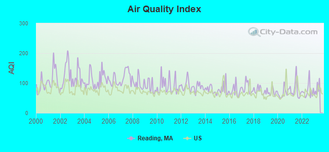
Air Quality Index (AQI) level in 2022 was 74.3. This is about average.
City:
74.3
U.S.:
72.6
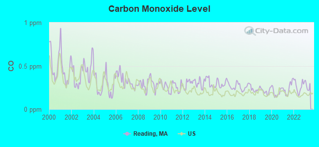
Carbon Monoxide (CO) [ppm] level in 2022 was 0.266. This is about average.Closest monitor was 8.0 miles away from the city center.
City:
0.266
U.S.:
0.251
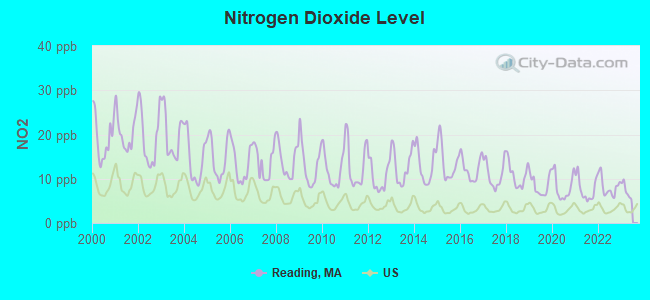
Nitrogen Dioxide (NO2) [ppb] level in 2022 was 8.17. This is significantly worse than average.Closest monitor was 3.9 miles away from the city center.
City:
8.17
U.S.:
5.11
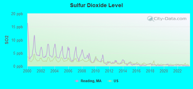
Sulfur Dioxide (SO2) [ppb] level in 2022 was 0.358. This is significantly better than average.Closest monitor was 3.5 miles away from the city center.
City:
0.358
U.S.:
1.515
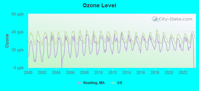
Ozone [ppb] level in 2022 was 27.4. This is better than average.Closest monitor was 8.0 miles away from the city center.
City:
27.4
U.S.:
33.3
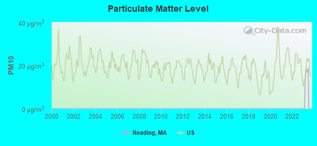
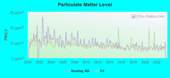
Particulate Matter (PM2.5) [µg/m3] level in 2022 was 6.54. This is better than average.Closest monitor was 7.9 miles away from the city center.
City:
6.54
U.S.:
8.11
Tornado activity:
Reading-area historical tornado activity is near Massachusetts state average. It is 41% smaller than the overall U.S. average.
On 6/9/1953, a category F4 (max. wind speeds 207-260 mph) tornado 26.1 miles away from the Reading place center killed 90 peopleand injured 1228 peopleand causedbetween $50,000,000 and $500,000,000 in damages.
On 9/29/1974, a category F3 (max. wind speeds 158-206 mph) tornado 8.0 miles away from the place center injured one personand causedbetween $50,000 and $500,000 in damages.
Earthquake activity:
Reading-area historical earthquake activity is significantly above Massachusetts state average. It is 73% smaller than the overall U.S. average.
On 4/20/2002 at 10:50:47, a magnitude 5.3 (5.3 ML, Depth: 3.0 mi, Class: Moderate, Intensity: VI - VII) earthquake occurred 189.0 miles away from Reading center On 10/7/1983 at 10:18:46, a magnitude 5.3 (5.1 MB, 5.3 LG, 5.1 ML) earthquake occurred 190.4 miles away from the city center On 1/19/1982 at 00:14:42, a magnitude 4.7 (4.5 MB, 4.7 MD, 4.5 LG, Class: Light, Intensity: IV - V) earthquake occurred 71.8 miles away from the city center On 10/16/2012 at 23:12:25, a magnitude 4.7 (4.7 ML, Depth: 10.0 mi) earthquake occurred 77.6 miles away from the city center On 4/20/2002 at 10:50:47, a magnitude 5.2 (5.2 MB, 4.2 MS, 5.2 MW, 5.0 MW) earthquake occurred 188.4 miles away from the city center On 8/22/1992 at 12:20:32, a magnitude 4.8 (4.8 MB, 3.8 MS, 4.7 LG, Depth: 6.2 mi) earthquake occurred 240.1 miles away from the city center Magnitude types: regional Lg-wave magnitude (LG), body-wave magnitude (MB), duration magnitude (MD), local magnitude (ML), surface-wave magnitude (MS), moment magnitude (MW)
Natural disasters:
The number of natural disasters in Middlesex County (31) is a lot greater than the US average (15). Major Disasters (Presidential) Declared: 17 Emergencies Declared: 14
Causes of natural disasters: Floods: 12, Storms: 9, Hurricanes: 6, Snowstorms: 6, Winter Storms: 5, Blizzards: 2, Snows: 2, Explosion: 1, Heavy Rain: 1, Snowfall: 1, Water Main Break: 1, Wind: 1 (Note: some incidents may be assigned to more than one category).
Main business address for: MASSBANK CORP (STATE COMMERCIAL BANKS).
Hospitals and medical centers in Reading:
DANIELS HOUSE NURSING HOME (59 MIDDLESEX AVENUE)
SOMERSET NURSING HOME (1364 MAIN ST)
WINGATE AT READING REHAB AND SKILLED NURS RESID (1364 MAIN STREET)
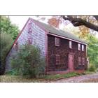
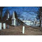
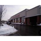
Notable locations in Reading: Meadowbrook Country Club (A), Grand City Plaza (B), Atlantic Plaza (C), Reading Townhall (D), Reading Fire Department Station 2 (E), Reading Fire Department Station 1 Headquarters (F), Arthur F Smith Library Media Center (G), A M Barrows School Library (H), Reading Town Hall (I), Reading Public Library (J), Parker Tavern (K). Display/hide their locations on the map
Tourist attraction: Beantown TAP (Arcades & Amusements; 2 Linden).
Birthplace of: Charles Austin Tweed - Jurist and politician, Sean Collins (ice hockey b. 1983) - Ice hockey player, Aaron Bancroft - Missionary, Charles A. Bessey - Army Medal of Honor recipient, James Cerretani - Tennis player, Chris Pizzotti - Football player, Mike Sullivan (ice hockey b. 1973) - Ice hockey player, Samuel Sheldon Poole - Politician, Steve Saviano - Ice hockey player.
Middlesex County has a predicted average indoor radon screening level greater than 4 pCi/L (pico curies per liter) - Highest Potential
Drinking water stations with addresses in Reading that have no violations reported:
READING WATER DEPARTMENT (Population served: 25,011,Primary Water Source Type: Purch surface water)
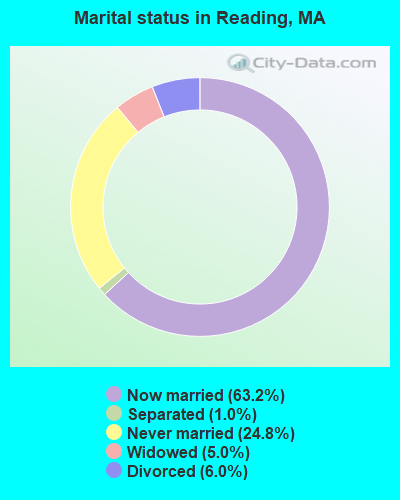
Average household size:
This place:
2.6 people
Massachusetts:
2.5 people
Percentage of family households:
This place:
71.8%
Whole state:
63.0%
Percentage of households with unmarried partners:
This place:
4.0%
Whole state:
7.0%
Likely homosexual households (counted as self-reported same-sex unmarried-partner households)
Lesbian couples: 0.4% of all households
Gay men: 0.3% of all households
People in group quarters in Reading in 2010:
147 people in nursing facilities/skilled-nursing facilities
25 people in group homes intended for adults
9 people in in-patient hospice facilities
People in group quarters in Reading in 2000:
146 people in nursing homes
15 people in homes for the mentally retarded
2 people in religious group quarters
Banks with branches in Reading (2011 data):
Bank of America, National Association: Reading-580 Main Branch at 580 Main Street, Suite 103, branch established on 1946/07/12; Walkers Brook Branch at 20 Walkers Brook Drive, branch established on 2005/08/29. Info updated 2009/11/18: Bank assets: $1,451,969.3 mil, Deposits: $1,077,176.8 mil, headquarters in Charlotte, NC, positive income, 5782 total offices, Holding Company: Bank Of America Corporation
Reading Co-operative Bank: Reading Co-Operative Bank at 180 Haven Street, branch established on 1886/01/01; Reading Memorial High School Branch at 62 Oakland Road, branch established on 2008/08/28. Info updated 2011/04/20: Bank assets: $347.2 mil, Deposits: $277.5 mil, local headquarters, positive income, Mortgage Lending Specialization, 6 total offices
Sovereign Bank, National Association: Reading Branch at 580 Main Street, branch established on 1972/05/26. Info updated 2012/01/31: Bank assets: $78,146.9 mil, Deposits: $48,042.9 mil, headquarters in Wilmington, DE, positive income, Commercial Lending Specialization, 718 total offices, Holding Company: Banco Santander, S.A.
TD Bank, National Association: Reading Branch at 470 Main Street, branch established on 1998/08/17. Info updated 2010/10/04: Bank assets: $188,912.6 mil, Deposits: $153,149.8 mil, headquarters in Wilmington, DE, positive income, 1314 total offices, Holding Company: Toronto-Dominion Bank, The
People's United Bank: Reading Branch at 31 Harnden Street, branch established on 2000/08/28. Info updated 2012/02/16: Bank assets: $27,319.3 mil, Deposits: $20,835.4 mil, headquarters in Bridgeport, CT, positive income, Commercial Lending Specialization, 374 total offices
RBS Citizens, National Association: Reading Stop & Shop Branch at 25 Walkers Brook Drive, branch established on 2007/09/21. Info updated 2007/09/19: Bank assets: $106,940.6 mil, Deposits: $75,690.2 mil, headquarters in Providence, RI, positive income, 1135 total offices, Holding Company: Uk Financial Investments Limited
Eastern Bank: Massbank Main Office at 123 Haven Street, branch established on 1872/04/05. Info updated 2011/03/30: Bank assets: $7,812.9 mil, Deposits: $6,295.8 mil, headquarters in Boston, MA, positive income, Commercial Lending Specialization, 94 total offices, Holding Company: Eastern Bank Corporation
Salem Five Cents Savings Bank: Reading Branch at 8 Walkers Brook Drive, branch established on 2009/04/06. Info updated 2011/07/11: Bank assets: $2,876.6 mil, Deposits: $2,019.1 mil, headquarters in Salem, MA, positive income, Commercial Lending Specialization, 23 total offices, Holding Company: Salem Five Bancorp
Religion statistics for Reading, MA (based on Middlesex County data)
Religion
Adherents
Congregations
Catholic
718,209
107
Mainline Protestant
70,053
269
Other
68,480
199
Evangelical Protestant
41,270
304
Orthodox
23,641
28
Black Protestant
2,276
8
None
579,156
-
Source: Clifford Grammich, Kirk Hadaway, Richard Houseal, Dale E.Jones, Alexei Krindatch, Richie Stanley and Richard H.Taylor. 2012. 2010 U.S.Religion Census: Religious Congregations & Membership Study. Association of Statisticians of American Religious Bodies. Jones, Dale E., et al. 2002. Congregations and Membership in the United States 2000. Nashville, TN: Glenmary Research Center. Graphs represent county-level data
Aircraft: PIPER PA-28-181 (Category: Land, Seats: 4, Weight: Up to 12,499 Pounds, Speed: 105 mph), Engine: LYCOMING 0-360-A1D (180 HP) (Reciprocating) N-Number: 283HP, N283HP, N-283HP, Serial Number: 2843360, Year manufactured: 2000, Airworthiness Date: 06/20/2000, Certificate Issue Date: 06/12/2003 Registrant (Individual): John D Jr Clarke, 147 Main St, Reading, MA 01867
Aircraft: CESSNA 182Q (Category: Land, Seats: 4, Weight: Up to 12,499 Pounds, Speed: 112 mph), Engine: CONT MOTOR O-470 SERIES (230 HP) (Reciprocating) N-Number: 759MY, N759MY, N-759MY, Serial Number: 18266114, Year manufactured: 1977, Airworthiness Date: 11/18/1977, Certificate Issue Date: 01/15/2020 Registrant (LLC): N759 My LLC, 29 Sherwood Rd, Reading, MA 01867
Aircraft: STINSON 108-1 (Category: Land, Seats: 4, Weight: Up to 12,499 Pounds, Speed: 84 mph), Engine: FRANKLIN 6A4150 SERIES (150 HP) (Reciprocating) N-Number: 97830, N97830, N-97830, Serial Number: 108-830, Year manufactured: 1946 Registrant (Individual): Albert M Duarte, 291 South St, Reading, MA 01867
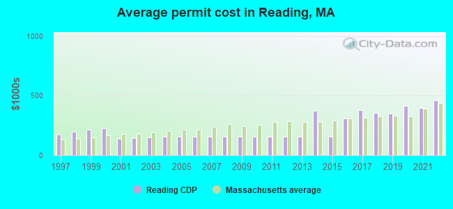
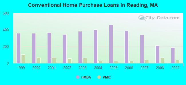
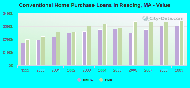
Home Mortgage Disclosure Act Aggregated Statistics For Year 2009 (Based on 4 full tracts)
A) FHA, FSA/RHS & VA Home Purchase Loans
B) Conventional Home Purchase Loans
C) Refinancings
D) Home Improvement Loans
E) Loans on Dwellings For 5+ Families
F) Non-occupant Loans on < 5 Family Dwellings (A B C & D)
Number
Average Value
Number
Average Value
Number
Average Value
Number
Average Value
Number
Average Value
Number
Average Value
LOANS ORIGINATED
44
$339,045
191
$308,110
1,156
$283,478
55
$197,727
2
$28,027,500
25
$289,280
APPLICATIONS APPROVED, NOT ACCEPTED
4
$357,750
11
$324,818
75
$305,200
6
$144,667
0
$0
1
$1,420,000
APPLICATIONS DENIED
2
$520,000
10
$280,300
169
$310,669
12
$144,917
0
$0
5
$248,200
APPLICATIONS WITHDRAWN
6
$385,167
22
$294,227
159
$297,182
5
$317,000
0
$0
0
$0
FILES CLOSED FOR INCOMPLETENESS
1
$234,000
9
$226,333
61
$317,672
5
$295,200
0
$0
0
$0
Aggregated Statistics For Year 2008 (Based on 4 full tracts)
A) FHA, FSA/RHS & VA Home Purchase Loans
B) Conventional Home Purchase Loans
C) Refinancings
D) Home Improvement Loans
E) Loans on Dwellings For 5+ Families
F) Non-occupant Loans on < 5 Family Dwellings (A B C & D)
Number
Average Value
Number
Average Value
Number
Average Value
Number
Average Value
Number
Average Value
Number
Average Value
LOANS ORIGINATED
26
$334,923
215
$302,219
445
$288,865
43
$134,372
2
$864,000
57
$326,737
APPLICATIONS APPROVED, NOT ACCEPTED
2
$425,000
27
$302,519
50
$321,180
6
$149,667
0
$0
7
$308,429
APPLICATIONS DENIED
3
$303,667
26
$265,615
106
$328,991
18
$50,889
1
$381,000
5
$317,600
APPLICATIONS WITHDRAWN
2
$300,500
36
$322,083
65
$304,508
5
$210,000
2
$2,815,000
1
$195,000
FILES CLOSED FOR INCOMPLETENESS
2
$330,000
8
$258,125
18
$327,111
0
$0
0
$0
1
$388,000
Aggregated Statistics For Year 2007 (Based on 4 full tracts)
A) FHA, FSA/RHS & VA Home Purchase Loans
B) Conventional Home Purchase Loans
C) Refinancings
D) Home Improvement Loans
E) Loans on Dwellings For 5+ Families
F) Non-occupant Loans on < 5 Family Dwellings (A B C & D)
Number
Average Value
Number
Average Value
Number
Average Value
Number
Average Value
Number
Average Value
Number
Average Value
LOANS ORIGINATED
1
$306,000
342
$277,073
387
$268,114
88
$118,830
3
$2,726,000
24
$328,875
APPLICATIONS APPROVED, NOT ACCEPTED
0
$0
42
$284,429
55
$256,655
18
$58,389
0
$0
2
$390,000
APPLICATIONS DENIED
0
$0
25
$351,320
111
$275,523
28
$93,179
1
$480,000
4
$186,750
APPLICATIONS WITHDRAWN
0
$0
29
$305,103
39
$280,410
4
$182,000
0
$0
2
$374,000
FILES CLOSED FOR INCOMPLETENESS
0
$0
1
$200,000
25
$287,840
0
$0
0
$0
0
$0
Aggregated Statistics For Year 2006 (Based on 4 full tracts)
B) Conventional Home Purchase Loans
C) Refinancings
D) Home Improvement Loans
E) Loans on Dwellings For 5+ Families
F) Non-occupant Loans on < 5 Family Dwellings (A B C & D)
G) Loans On Manufactured Home Dwelling (A B C & D)
Number
Average Value
Number
Average Value
Number
Average Value
Number
Average Value
Number
Average Value
Number
Average Value
LOANS ORIGINATED
389
$249,715
470
$243,143
103
$110,437
0
$0
32
$252,406
0
$0
APPLICATIONS APPROVED, NOT ACCEPTED
42
$263,381
79
$234,924
15
$79,933
1
$1,200,000
4
$334,750
0
$0
APPLICATIONS DENIED
34
$256,529
149
$275,470
36
$109,611
0
$0
11
$201,818
1
$331,000
APPLICATIONS WITHDRAWN
38
$266,026
158
$265,063
8
$188,125
1
$8,300,000
7
$147,429
0
$0
FILES CLOSED FOR INCOMPLETENESS
10
$318,000
24
$323,875
3
$50,000
0
$0
3
$404,333
0
$0
Aggregated Statistics For Year 2005 (Based on 4 full tracts)
A) FHA, FSA/RHS & VA Home Purchase Loans
B) Conventional Home Purchase Loans
C) Refinancings
D) Home Improvement Loans
E) Loans on Dwellings For 5+ Families
F) Non-occupant Loans on < 5 Family Dwellings (A B C & D)
G) Loans On Manufactured Home Dwelling (A B C & D)
Number
Average Value
Number
Average Value
Number
Average Value
Number
Average Value
Number
Average Value
Number
Average Value
Number
Average Value
LOANS ORIGINATED
1
$50,000
460
$283,083
667
$276,208
109
$162,972
2
$751,500
36
$323,778
0
$0
APPLICATIONS APPROVED, NOT ACCEPTED
0
$0
36
$225,583
50
$264,480
10
$121,300
0
$0
3
$338,333
1
$110,000
APPLICATIONS DENIED
0
$0
46
$277,870
128
$279,828
24
$113,625
0
$0
11
$302,091
0
$0
APPLICATIONS WITHDRAWN
1
$360,000
51
$254,431
199
$293,347
16
$243,750
0
$0
11
$351,000
0
$0
FILES CLOSED FOR INCOMPLETENESS
0
$0
4
$237,750
19
$339,474
1
$150,000
0
$0
2
$341,000
0
$0
Aggregated Statistics For Year 2004 (Based on 4 full tracts)
A) FHA, FSA/RHS & VA Home Purchase Loans
B) Conventional Home Purchase Loans
C) Refinancings
D) Home Improvement Loans
E) Loans on Dwellings For 5+ Families
F) Non-occupant Loans on < 5 Family Dwellings (A B C & D)
G) Loans On Manufactured Home Dwelling (A B C & D)
Number
Average Value
Number
Average Value
Number
Average Value
Number
Average Value
Number
Average Value
Number
Average Value
Number
Average Value
LOANS ORIGINATED
2
$129,000
403
$278,169
804
$245,358
95
$147,189
3
$306,667
28
$237,036
1
$15,000
APPLICATIONS APPROVED, NOT ACCEPTED
0
$0
41
$323,439
72
$241,111
16
$112,812
1
$450,000
3
$112,000
0
$0
APPLICATIONS DENIED
0
$0
40
$312,375
115
$274,965
37
$84,297
0
$0
7
$373,000
1
$51,000
APPLICATIONS WITHDRAWN
0
$0
40
$262,775
132
$251,348
11
$113,909
2
$775,000
3
$256,667
0
$0
FILES CLOSED FOR INCOMPLETENESS
0
$0
2
$510,000
43
$273,000
6
$162,500
0
$0
0
$0
0
$0
Aggregated Statistics For Year 2003 (Based on 4 full tracts)
A) FHA, FSA/RHS & VA Home Purchase Loans
B) Conventional Home Purchase Loans
C) Refinancings
D) Home Improvement Loans
E) Loans on Dwellings For 5+ Families
F) Non-occupant Loans on < 5 Family Dwellings (A B C & D)
Number
Average Value
Number
Average Value
Number
Average Value
Number
Average Value
Number
Average Value
Number
Average Value
LOANS ORIGINATED
5
$247,600
382
$262,115
2,359
$211,904
41
$74,659
1
$519,000
52
$217,000
APPLICATIONS APPROVED, NOT ACCEPTED
0
$0
46
$255,478
216
$210,231
18
$72,222
0
$0
3
$315,000
APPLICATIONS DENIED
0
$0
40
$245,275
233
$246,309
22
$63,727
1
$400,000
7
$250,429
APPLICATIONS WITHDRAWN
0
$0
33
$270,818
195
$228,728
10
$61,900
1
$211,000
5
$326,000
FILES CLOSED FOR INCOMPLETENESS
0
$0
5
$318,000
24
$226,750
1
$35,000
0
$0
1
$500,000
Aggregated Statistics For Year 2002 (Based on 4 full tracts)
A) FHA, FSA/RHS & VA Home Purchase Loans
B) Conventional Home Purchase Loans
C) Refinancings
D) Home Improvement Loans
E) Loans on Dwellings For 5+ Families
F) Non-occupant Loans on < 5 Family Dwellings (A B C & D)
Number
Average Value
Number
Average Value
Number
Average Value
Number
Average Value
Number
Average Value
Number
Average Value
LOANS ORIGINATED
2
$137,500
346
$251,370
1,796
$202,375
91
$81,868
2
$415,000
37
$231,703
APPLICATIONS APPROVED, NOT ACCEPTED
0
$0
47
$273,553
185
$199,627
25
$45,040
0
$0
4
$281,000
APPLICATIONS DENIED
0
$0
23
$261,130
143
$210,881
22
$50,318
1
$400,000
4
$195,250
APPLICATIONS WITHDRAWN
1
$247,000
22
$290,455
199
$201,231
4
$31,250
0
$0
4
$250,750
FILES CLOSED FOR INCOMPLETENESS
0
$0
9
$345,333
32
$250,031
0
$0
0
$0
0
$0
Aggregated Statistics For Year 2001 (Based on 4 full tracts)
A) FHA, FSA/RHS & VA Home Purchase Loans
B) Conventional Home Purchase Loans
C) Refinancings
D) Home Improvement Loans
E) Loans on Dwellings For 5+ Families
F) Non-occupant Loans on < 5 Family Dwellings (A B C & D)
Number
Average Value
Number
Average Value
Number
Average Value
Number
Average Value
Number
Average Value
Number
Average Value
LOANS ORIGINATED
10
$167,100
368
$220,133
1,261
$190,707
76
$62,079
2
$127,500
33
$191,788
APPLICATIONS APPROVED, NOT ACCEPTED
1
$239,000
27
$222,037
115
$168,965
28
$34,857
1
$600,000
3
$156,333
APPLICATIONS DENIED
1
$135,000
17
$193,529
110
$183,109
33
$77,545
0
$0
6
$221,000
APPLICATIONS WITHDRAWN
1
$305,000
16
$210,688
125
$200,640
11
$42,182
0
$0
1
$375,000
FILES CLOSED FOR INCOMPLETENESS
0
$0
2
$229,500
21
$174,810
2
$29,500
0
$0
1
$100,000
Aggregated Statistics For Year 2000 (Based on 4 full tracts)
A) FHA, FSA/RHS & VA Home Purchase Loans
B) Conventional Home Purchase Loans
C) Refinancings
D) Home Improvement Loans
F) Non-occupant Loans on < 5 Family Dwellings (A B C & D)
Number
Average Value
Number
Average Value
Number
Average Value
Number
Average Value
Number
Average Value
LOANS ORIGINATED
4
$198,500
359
$193,535
224
$150,415
74
$44,838
28
$147,500
APPLICATIONS APPROVED, NOT ACCEPTED
0
$0
33
$189,939
54
$143,481
19
$49,789
6
$195,667
APPLICATIONS DENIED
0
$0
19
$209,053
64
$135,375
34
$38,029
7
$165,286
APPLICATIONS WITHDRAWN
2
$125,000
33
$213,030
52
$120,596
7
$35,714
2
$237,500
FILES CLOSED FOR INCOMPLETENESS
0
$0
7
$194,429
22
$205,318
0
$0
2
$272,500
Aggregated Statistics For Year 1999 (Based on 4 full tracts)
A) FHA, FSA/RHS & VA Home Purchase Loans
B) Conventional Home Purchase Loans
C) Refinancings
D) Home Improvement Loans
E) Loans on Dwellings For 5+ Families
F) Non-occupant Loans on < 5 Family Dwellings (A B C & D)
2002 - 2018 National Fire Incident Reporting System (NFIRS) incidents
Based on the data from the years 2002 - 2018 the average number of fires per year is 79. The highest number of reported fires - 177 took place in 2007, and the least - 46 in 2002. The data has a growing trend.
When looking into fire subcategories, the most incidents belonged to: Structure Fires (58.2%), and Outside Fires (16.5%).
Fire incident types reported to NFIRS in Reading, MA
#60 on the list of "Top 101 cities with the lowest percentage of single-parent households, population 5,000+"
#77 on the list of "Top 101 cities with largest percentage of females in occupations: health diagnosing and treating practitioners and other technical occupations (population 5,000+)"
#85 (01801) on the list of "Top 101 zip codes with the largest percentage of Irish first ancestries (pop 5,000+)"
#4 on the list of "Top 101 counties with the most Orthodox adherents"
#7 on the list of "Top 101 counties with the most Catholic adherents"
#7 on the list of "Top 101 counties with the most Mainline Protestant congregations"
#7 on the list of "Top 101 counties with the most Orthodox congregations"
#8 on the list of "Top 101 counties with the lowest percentage of residents that keep firearms around their homes"


 Recent articles from our blog. Our writers, many of them Ph.D. graduates or candidates, create easy-to-read articles on a wide variety of topics.

 (7.2 miles


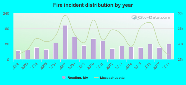 Based on the data from the years 2002 - 2018 the average number of fires per year is 79. The highest number of reported fires - 177 took place in 2007, and the least - 46 in 2002. The data has a growing trend.
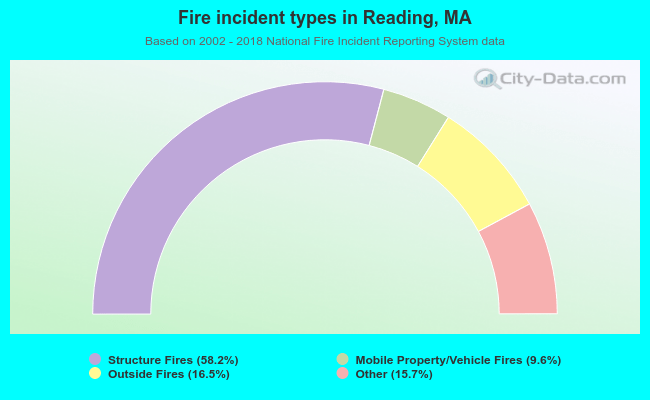 When looking into fire subcategories, the most incidents belonged to: Structure Fires (58.2%), and Outside Fires (16.5%).