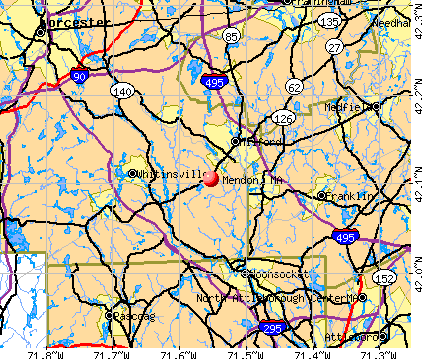
Mendon, Massachusetts

Mendon: Autumn color at the old cemetery in Mendon

Mendon: Nipmuc Lake

Mendon: Nipmuc Lake
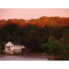
Mendon: Nipmuc Lake
- add
your
Submit your own pictures of this town and show them to the world
- OSM Map
- General Map
- Google Map
- MSN Map
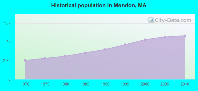
Population change since 2000: +10.5%
 |
| Males: 2,924 | |
| Females: 2,915 |
| Median resident age: | 42.1 years |
| Massachusetts median age: | 39.2 years |
Zip codes: 01756.
| Mendon: | $128,221 |
| MA: | $94,488 |
Estimated per capita income in 2022: $53,996 (it was $27,693 in 2000)
Mendon town income, earnings, and wages data
Estimated median house or condo value in 2022: $653,940 (it was $236,800 in 2000)
| Mendon: | $653,940 |
| MA: | $534,700 |
Mean prices in 2022: all housing units: $419,164; detached houses: $447,621; townhouses or other attached units: $343,592; in 2-unit structures: $323,295; in 3-to-4-unit structures: $332,295; in 5-or-more-unit structures: $232,758; mobile homes: $113,885
Detailed information about poverty and poor residents in Mendon, MA


- 5,63196.4%White alone
- 731.3%Hispanic
- 571.0%Asian alone
- 520.9%Two or more races
- 170.3%Black alone
- 50.09%Other race alone
- 20.03%American Indian alone
- 20.03%Native Hawaiian and Other
Pacific Islander alone
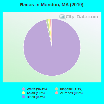
Races in Mendon detailed stats: ancestries, foreign born residents, place of birth
Type |
2009 |
2010 |
2011 |
2012 |
2013 |
2014 |
2015 |
2016 |
2017 |
2018 |
2019 |
2020 |
2021 |
2022 |
|---|---|---|---|---|---|---|---|---|---|---|---|---|---|---|
| Murders (per 100,000) | 0 (0.0) | 0 (0.0) | 0 (0.0) | 0 (0.0) | 0 (0.0) | 0 (0.0) | 0 (0.0) | 0 (0.0) | 0 (0.0) | 0 (0.0) | 0 (0.0) | 0 (0.0) | 0 (0.0) | 0 (0.0) |
| Rapes (per 100,000) | 0 (0.0) | 2 (34.3) | 0 (0.0) | 2 (33.8) | 0 (0.0) | 0 (0.0) | 0 (0.0) | 0 (0.0) | 1 (16.5) | 0 (0.0) | 0 (0.0) | 0 (0.0) | 0 (0.0) | 0 (0.0) |
| Robberies (per 100,000) | 0 (0.0) | 1 (17.1) | 1 (17.0) | 0 (0.0) | 0 (0.0) | 0 (0.0) | 0 (0.0) | 0 (0.0) | 0 (0.0) | 0 (0.0) | 0 (0.0) | 0 (0.0) | 0 (0.0) | 0 (0.0) |
| Assaults (per 100,000) | 8 (136.4) | 6 (102.8) | 6 (102.1) | 3 (50.7) | 5 (84.7) | 6 (101.1) | 3 (50.1) | 3 (49.7) | 8 (131.8) | 4 (65.3) | 3 (48.6) | 3 (48.1) | 6 (94.9) | 4 (63.4) |
| Burglaries (per 100,000) | 22 (375.0) | 18 (308.3) | 8 (136.2) | 14 (236.8) | 17 (288.0) | 16 (269.5) | 8 (133.5) | 11 (182.3) | 11 (181.2) | 4 (65.3) | 2 (32.4) | 2 (32.1) | 3 (47.4) | 3 (47.6) |
| Thefts (per 100,000) | 35 (596.7) | 33 (565.2) | 19 (323.4) | 26 (439.7) | 39 (660.8) | 19 (320.1) | 25 (417.3) | 21 (348.1) | 27 (444.9) | 24 (391.5) | 9 (145.7) | 18 (288.8) | 23 (363.8) | 17 (269.5) |
| Auto thefts (per 100,000) | 5 (85.2) | 4 (68.5) | 3 (51.1) | 4 (67.6) | 1 (16.9) | 2 (33.7) | 3 (50.1) | 6 (99.5) | 5 (82.4) | 3 (48.9) | 5 (81.0) | 0 (0.0) | 4 (63.3) | 2 (31.7) |
| Arson (per 100,000) | 2 (34.1) | 1 (17.1) | 0 (0.0) | 1 (16.9) | 0 (0.0) | 1 (16.8) | 1 (16.7) | 0 (0.0) | 0 (0.0) | 0 (0.0) | 0 (0.0) | 0 (0.0) | 0 (0.0) | 0 (0.0) |
| City-Data.com crime index | 84.2 | 102.8 | 52.1 | 76.8 | 64.9 | 54.6 | 40.1 | 44.6 | 76.6 | 37.2 | 24.3 | 23.4 | 41.9 | 29.3 |
The City-Data.com crime index weighs serious crimes and violent crimes more heavily. Higher means more crime, U.S. average is 246.1. It adjusts for the number of visitors and daily workers commuting into cities.
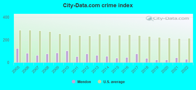
Crime rate in Mendon detailed stats: murders, rapes, robberies, assaults, burglaries, thefts, arson
Full-time law enforcement employees in 2021, including police officers: 14 (13 officers - 12 male; 1 female).
| Officers per 1,000 residents here: | 2.06 |
| Massachusetts average: | 2.53 |
 Recent articles from our blog. Our writers, many of them Ph.D. graduates or candidates, create easy-to-read articles on a wide variety of topics.

 | Mendon, Upton, Sutton (37 replies) |
| Under $250k any Massachusetts single family house with yard (117 replies) |
| How many movie theaters will be left? (21 replies) |
| Amtrak and MassDOT piloting new Valley Flyer service in Western Mass (248 replies) |
| What is living in Sutton, MA like? (18 replies) |
| the real map of boston (123 replies) |
Latest news from Mendon, MA collected exclusively by city-data.com from local newspapers, TV, and radio stations
Ancestries: Irish (27.5%), Italian (23.4%), English (19.7%), German (10.7%), French (9.5%), Polish (4.9%).
Current Local Time: EST time zone
Incorporated in 1667
Elevation: 330 feet
Land area: 18.1 square miles.
Population density: 323 people per square mile (very low).
136 residents are foreign born (1.8% Europe, 0.6% Asia).
| This town: | 2.6% |
| Massachusetts: | 12.2% |
| Mendon town: | 1.1% ($2,559) |
| Massachusetts: | 1.3% ($2,336) |
Nearest city with pop. 50,000+: Framingham, MA  (15.6 miles , pop. 66,910).
Nearest city with pop. 200,000+: Boston, MA (28.2 miles , pop. 589,141).
Nearest city with pop. 1,000,000+: Bronx, NY (148.3 miles , pop. 1,332,650).
Nearest cities:
), ), ), )Latitude: 42.09 N, Longitude: 71.54 W

Single-family new house construction building permits:
- 2022: 18 buildings, average cost: $391,400
- 2021: 17 buildings, average cost: $270,000
- 2020: 16 buildings, average cost: $296,500
- 2019: 19 buildings, average cost: $296,900
- 2018: 26 buildings, average cost: $279,900
- 2017: 24 buildings, average cost: $283,500
- 2016: 20 buildings, average cost: $278,900
- 2015: 10 buildings, average cost: $254,700
- 2014: 20 buildings, average cost: $277,300
- 2013: 19 buildings, average cost: $186,400
- 2012: 6 buildings, average cost: $214,300
- 2011: 3 buildings, average cost: $264,000
- 2010: 5 buildings, average cost: $145,700
- 2009: 6 buildings, average cost: $251,400
- 2008: 5 buildings, average cost: $228,500
- 2007: 10 buildings, average cost: $286,000
- 2006: 27 buildings, average cost: $201,800
- 2005: 23 buildings, average cost: $251,900
- 2004: 11 buildings, average cost: $261,400
- 2003: 33 buildings, average cost: $276,100
- 2002: 42 buildings, average cost: $215,400
- 2001: 37 buildings, average cost: $182,500
- 2000: 47 buildings, average cost: $187,100
- 1999: 60 buildings, average cost: $144,500
- 1998: 62 buildings, average cost: $135,500
- 1997: 77 buildings, average cost: $122,600
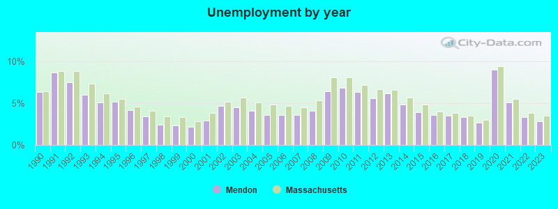
| Here: | 2.8% |
| Massachusetts: | 3.5% |
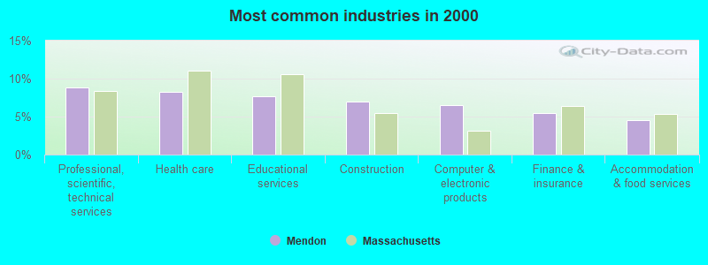
- Professional, scientific, technical services (8.8%)
- Health care (8.2%)
- Educational services (7.7%)
- Construction (7.0%)
- Computer & electronic products (6.5%)
- Finance & insurance (5.5%)
- Accommodation & food services (4.5%)
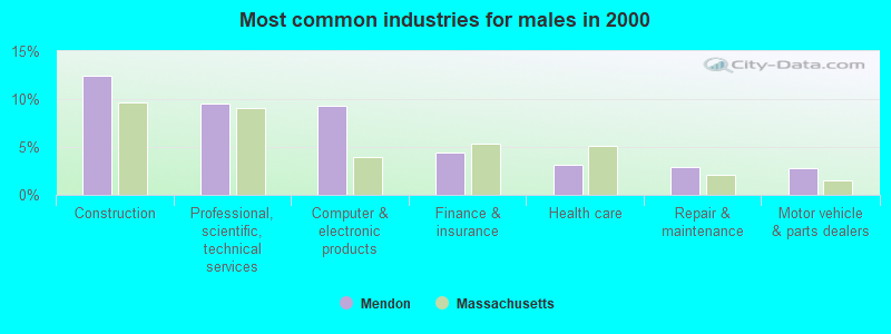
- Construction (12.5%)
- Professional, scientific, technical services (9.5%)
- Computer & electronic products (9.2%)
- Finance & insurance (4.5%)
- Health care (3.2%)
- Repair & maintenance (2.9%)
- Motor vehicle & parts dealers (2.7%)

- Health care (14.2%)
- Educational services (13.9%)
- Professional, scientific, technical services (8.0%)
- Accommodation & food services (6.7%)
- Finance & insurance (6.7%)
- Public administration (4.3%)
- Computer & electronic products (3.3%)
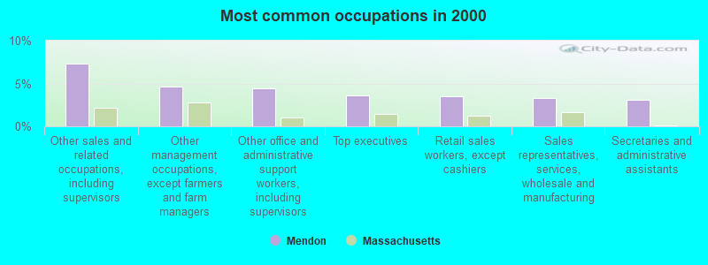
- Other sales and related occupations, including supervisors (7.3%)
- Other management occupations, except farmers and farm managers (4.6%)
- Other office and administrative support workers, including supervisors (4.4%)
- Top executives (3.6%)
- Retail sales workers, except cashiers (3.5%)
- Sales representatives, services, wholesale and manufacturing (3.3%)
- Secretaries and administrative assistants (3.0%)
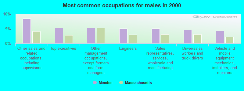
- Other sales and related occupations, including supervisors (8.5%)
- Top executives (5.3%)
- Other management occupations, except farmers and farm managers (5.2%)
- Engineers (5.1%)
- Sales representatives, services, wholesale and manufacturing (5.1%)
- Driver/sales workers and truck drivers (4.6%)
- Vehicle and mobile equipment mechanics, installers, and repairers (4.3%)
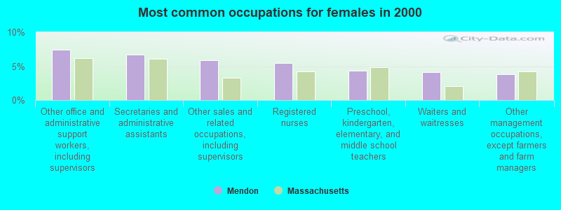
- Other office and administrative support workers, including supervisors (7.4%)
- Secretaries and administrative assistants (6.7%)
- Other sales and related occupations, including supervisors (5.9%)
- Registered nurses (5.5%)
- Preschool, kindergarten, elementary, and middle school teachers (4.3%)
- Waiters and waitresses (4.2%)
- Other management occupations, except farmers and farm managers (3.9%)
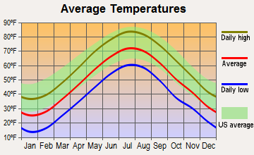
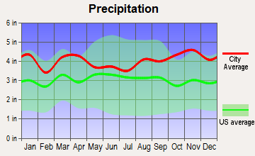
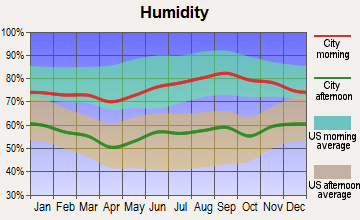
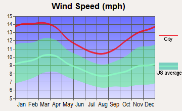
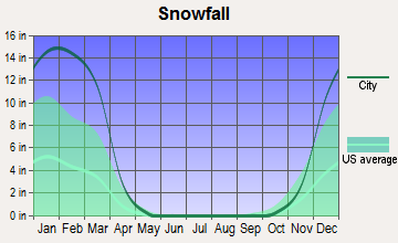
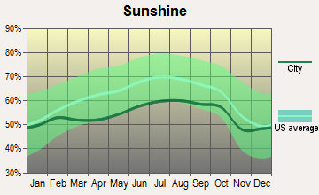
Average climate in Mendon, Massachusetts
Based on data reported by over 4,000 weather stations
(lower is better)
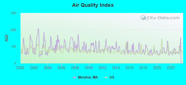
Air Quality Index (AQI) level in 2022 was 66.0. This is about average.
| City: | 66.0 |
| U.S.: | 72.6 |
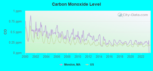
Carbon Monoxide (CO) [ppm] level in 2022 was 0.232. This is about average. Closest monitor was 16.9 miles away from the city center.
| City: | 0.232 |
| U.S.: | 0.251 |
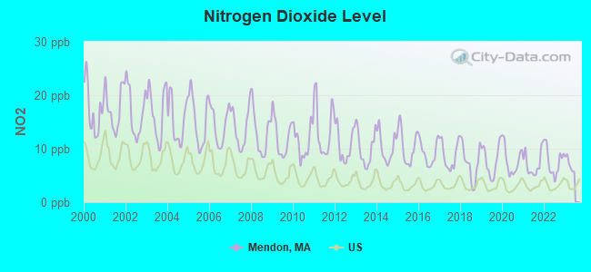
Nitrogen Dioxide (NO2) [ppb] level in 2022 was 7.57. This is significantly worse than average. Closest monitor was 6.5 miles away from the city center.
| City: | 7.57 |
| U.S.: | 5.11 |
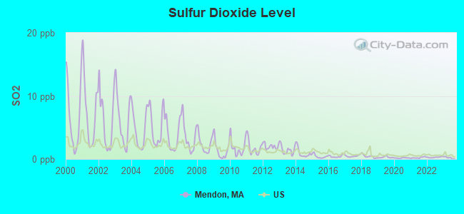
Sulfur Dioxide (SO2) [ppb] level in 2022 was 0.287. This is significantly better than average. Closest monitor was 6.5 miles away from the city center.
| City: | 0.287 |
| U.S.: | 1.515 |
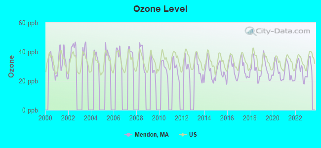
Ozone [ppb] level in 2022 was 27.2. This is better than average. Closest monitor was 3.9 miles away from the city center.
| City: | 27.2 |
| U.S.: | 33.3 |
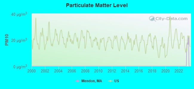
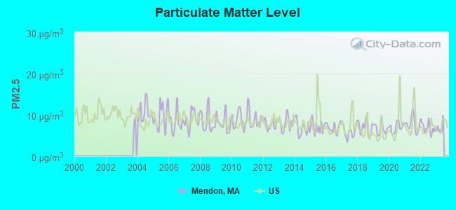
Particulate Matter (PM2.5) [µg/m3] level in 2022 was 6.92. This is about average. Closest monitor was 14.0 miles away from the city center.
| City: | 6.92 |
| U.S.: | 8.11 |
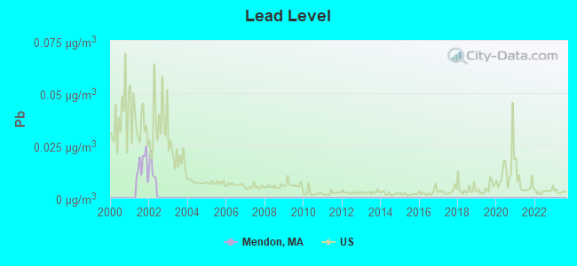
Lead (Pb) [µg/m3] level in 2001 was 0.0157. This is significantly worse than average. Closest monitor was 17.3 miles away from the city center.
| City: | 0.0157 |
| U.S.: | 0.0093 |
Tornado activity:
Mendon-area historical tornado activity is near Massachusetts state average. It is 33% smaller than the overall U.S. average.
On 6/9/1953, a category F4 (max. wind speeds 207-260 mph) tornado 14.4 miles away from the Mendon town center killed 90 people and injured 1228 people and caused between $50,000,000 and $500,000,000 in damages.
On 6/9/1953, a category F3 (max. wind speeds 158-206 mph) tornado 12.8 miles away from the town center injured 17 people and caused between $500,000 and $5,000,000 in damages.
Earthquake activity:
Mendon-area historical earthquake activity is significantly above Massachusetts state average. It is 73% smaller than the overall U.S. average.On 10/7/1983 at 10:18:46, a magnitude 5.3 (5.1 MB, 5.3 LG, 5.1 ML, Class: Moderate, Intensity: VI - VII) earthquake occurred 191.2 miles away from Mendon center
On 4/20/2002 at 10:50:47, a magnitude 5.3 (5.3 ML, Depth: 3.0 mi) earthquake occurred 199.4 miles away from Mendon center
On 4/20/2002 at 10:50:47, a magnitude 5.2 (5.2 MB, 4.2 MS, 5.2 MW, 5.0 MW) earthquake occurred 198.5 miles away from Mendon center
On 1/19/1982 at 00:14:42, a magnitude 4.7 (4.5 MB, 4.7 MD, 4.5 LG, Class: Light, Intensity: IV - V) earthquake occurred 97.4 miles away from Mendon center
On 10/16/2012 at 23:12:25, a magnitude 4.7 (4.7 ML, Depth: 10.0 mi) earthquake occurred 113.5 miles away from the city center
On 8/22/1992 at 12:20:32, a magnitude 4.8 (4.8 MB, 3.8 MS, 4.7 LG, Depth: 6.2 mi) earthquake occurred 216.3 miles away from Mendon center
Magnitude types: regional Lg-wave magnitude (LG), body-wave magnitude (MB), duration magnitude (MD), local magnitude (ML), surface-wave magnitude (MS), moment magnitude (MW)
Natural disasters:
The number of natural disasters in Worcester County (27) is a lot greater than the US average (15).Major Disasters (Presidential) Declared: 15
Emergencies Declared: 12
Causes of natural disasters: Floods: 9, Storms: 8, Hurricanes: 6, Snowstorms: 5, Winter Storms: 4, Blizzards: 2, Snows: 2, Fire: 1, Heavy Rain: 1, Snowfall: 1, Tornado: 1, Wind: 1 (Note: some incidents may be assigned to more than one category).

Hospitals and medical centers in Mendon:
Other hospitals and medical centers near Mendon:
- CONTINUING CARE CENTER AT HOPEDALE (Nursing Home, about 3 miles away; HOPEDALE, MA)
- HOPEDALE GARDEN NURSING HOME (Nursing Home, about 3 miles away; HOPEDALE, MA)
- ADIN MANOR CONVALESCENT HOME,T (Nursing Home, about 3 miles away; HOPEDALE, MA)
- FMC DIALYSIS SERVICES OF BLACKSTONE VALLEY (Dialysis Facility, about 3 miles away; MILFORD, MA)
- MILFORD REGIONAL MEDICAL CENTER Acute Care Hospitals (about 3 miles away; MILFORD, MA)
- BLAIRE HOUSE OF MILFORD (Nursing Home, about 4 miles away; MILFORD, MA)
- MILFORD CARE AND REHABILITATION CENTER (Nursing Home, about 5 miles away; MILFORD, MA)
Amtrak stations near Mendon:
- 15 miles: FRAMINGHAM (443 WAVERLY ST.) . Services: public payphones, snack bar, paid short-term parking, taxi stand, public transit connection.
- 18 miles: WORCESTER (WORCHESTER, 45 SHREWSBURY ST.) . Services: ticket office, fully wheelchair accessible, enclosed waiting area, public restrooms, public payphones, vending machines, free short-term parking, free long-term parking, call for taxi service, public transit connection.
- 20 miles: PROVIDENCE (100 GASPEE ST.) . Services: ticket office, fully wheelchair accessible, enclosed waiting area, public restrooms, public payphones, snack bar, ATM, paid short-term parking, paid long-term parking, call for car rental service, taxi stand, public transit connection.
Colleges/universities with over 2000 students nearest to Mendon:
- Bryant University (about 12 miles; Smithfield, RI; Full-time enrollment: 3,440)
- Framingham State University (about 16 miles; Framingham, MA; FT enrollment: 5,743)
- College of the Holy Cross (about 17 miles; Worcester, MA; FT enrollment: 3,125)
- Rhode Island College (about 18 miles; Providence, RI; FT enrollment: 7,189)
- Providence College (about 19 miles; Providence, RI; FT enrollment: 4,312)
- Clark University (about 19 miles; Worcester, MA; FT enrollment: 3,687)
- Wellesley College (about 19 miles; Wellesley, MA; FT enrollment: 2,658)
Private high school in Mendon:
Public elementary/middle schools in Mendon:
- MISCOE HILL SCHOOL (Students: 954, Location: 148 NORTH AVENUE, Grades: 5-8)
- HENRY P CLOUGH (Students: 451, Location: 10 NORTH AVENUE, Grades: PK-4)
Points of interest:
Notable locations in Mendon: Mendon Industrial Park (A), Mendon Fire Department (B), Taft Public Library (C), Mendon Town Hall (D). Display/hide their locations on the map
Churches in Mendon include: Saint Michaels Church (A), Unitarian Congregation Church (B), First Baptist Church in Mendon (C), Bethany Assembly of God Church (D). Display/hide their locations on the map
Cemeteries: Wood Cemetery (1), Pine Hill Cemetery (2), Swandale Cemetery (3), Friends Cemetery (4), George Cemetery (5), Locust Hill Cemetery (6), South Hopedale Cemetery (7). Display/hide their locations on the map
Lakes, reservoirs, and swamps: Little Pond (A), Nipmack Pond (B), West River Pond (C), Lake Hiawatha (D), Factory Pond (E), Long Meadow (F). Display/hide their locations on the map
Streams, rivers, and creeks: Quissett Brook (A), Muddy Brook (B), Ohio Brook (C), Round Meadow Brook (D), Spring Brook (E), Wigwam Brook (F), Willow Brook (G). Display/hide their locations on the map
Birthplace of: Simeon Thayer - General, Simeon Wheelock - Minuteman, Eli Thayer - Politician, Benjamin Adams (politician) - Politician.
Drinking water stations with addresses in Mendon and their reported violations in the past:
MENDON WATER DEPARTMENT (Population served: 360, Purch groundwater under infl of surface water):Past monitoring violations:MENDON HOUSING AUTHORITY (Population served: 31, Groundwater):
- Follow-up Or Routine LCR Tap M/R - In JUL-01-2013, Contaminant: Lead and Copper Rule. Follow-up actions: St AO (w/o penalty) issued (NOV-26-2013)
- Monitoring and Reporting (DBP) - Between APR-2008 and JUN-2008, Contaminant: Chlorine. Follow-up actions: St AO (w/o penalty) issued (SEP-04-2008), St Compliance achieved (SEP-04-2008)
- Monitoring and Reporting (DBP) - Between JAN-2006 and MAR-2006, Contaminant: Chlorine. Follow-up actions: St AO (w/o penalty) issued (FEB-17-2006)
- Monitoring and Reporting (DBP) - Between JAN-2006 and DEC-2006, Contaminant: TTHM. Follow-up actions: St AO (w/o penalty) issued (DEC-12-2006), St Compliance achieved (DEC-28-2006)
- Monitoring and Reporting (DBP) - Between JAN-2006 and DEC-2006, Contaminant: Total Haloacetic Acids (HAA5). Follow-up actions: St AO (w/o penalty) issued (DEC-12-2006), St Compliance achieved (DEC-28-2006)
- One minor monitoring violation
- 3 other older monitoring violations
Past health violations:Past monitoring violations:
- MCL, Monthly (TCR) - In SEP-2011, Contaminant: Coliform. Follow-up actions: St AO (w/o penalty) issued (NOV-04-2011), St Compliance achieved (NOV-04-2011)
- MCL, Monthly (TCR) - In DEC-2007, Contaminant: Coliform. Follow-up actions: St AO (w/o penalty) issued (FEB-01-2007)
- 2 minor monitoring violations
- 23 regular monitoring violations
| This town: | 2.9 people |
| Massachusetts: | 2.5 people |
| This town: | 81.0% |
| Whole state: | 63.0% |
| This town: | 4.3% |
| Whole state: | 7.0% |
Likely homosexual households (counted as self-reported same-sex unmarried-partner households)
- Lesbian couples: 0.4% of all households
- Gay men: 0.3% of all households
| This town: | 4.0% |
| Whole state: | 9.3% |
| This town: | 1.3% |
| Whole state: | 4.4% |
8 people in residential treatment centers for juveniles (non-correctional) in 2010
15 people in homes for the mentally retarded in 2000
Banks with branches in Mendon (2011 data):
- Dean Co-operative Bank: Mendon Branch at 32 Hastings Street, branch established on 2006/05/25. Info updated 2006/11/03: Bank assets: $223.1 mil, Deposits: $183.8 mil, headquarters in Franklin, MA, positive income, Mortgage Lending Specialization, 5 total offices
- Charles River Bank: Branch at 1 Hasting St, branch established on 2010/04/12. Info updated 2009/07/27: Bank assets: $187.0 mil, Deposits: $156.1 mil, headquarters in Medway, MA, positive income, Mortgage Lending Specialization, 4 total offices, Holding Company: Charles River Bancorp, Mhc
- The Milford National Bank and Trust Company: Mendon Branch at 14 Hastings Street, Route 16, branch established on 1991/01/22. Info updated 2006/11/03: Bank assets: $267.5 mil, Deposits: $233.6 mil, headquarters in Milford, MA, positive income, Commercial Lending Specialization, 6 total offices, Holding Company: Mnb Bancorp
For population 15 years and over in Mendon:
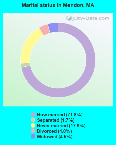
- Never married: 17.9%
- Now married: 71.8%
- Separated: 1.7%
- Widowed: 4.5%
- Divorced: 4.0%
For population 25 years and over in Mendon:
- High school or higher: 93.2%
- Bachelor's degree or higher: 35.9%
- Graduate or professional degree: 10.8%
- Unemployed: 1.2%
- Mean travel time to work (commute): 29.2 minutes
| Here: | 9.8 |
| Massachusetts average: | 13.1 |


Graphs represent county-level data. Detailed 2008 Election Results
Religion statistics for Mendon, MA (based on Worcester County data)


| Religion | Adherents | Congregations |
|---|---|---|
| Catholic | 306,925 | 118 |
| Mainline Protestant | 43,326 | 171 |
| Evangelical Protestant | 37,511 | 203 |
| Other | 18,931 | 69 |
| Orthodox | 7,935 | 15 |
| Black Protestant | 497 | 6 |
| None | 383,427 | - |
Food Environment Statistics:
| This county: | 1.73 / 10,000 pop. |
| Massachusetts: | 1.98 / 10,000 pop. |
| Worcester County: | 0.05 / 10,000 pop. |
| Massachusetts: | 0.05 / 10,000 pop. |
| Worcester County: | 1.79 / 10,000 pop. |
| State: | 2.22 / 10,000 pop. |
| Here: | 2.22 / 10,000 pop. |
| State: | 1.77 / 10,000 pop. |
| Worcester County: | 7.27 / 10,000 pop. |
| Massachusetts: | 8.76 / 10,000 pop. |
| Worcester County: | 8.0% |
| Massachusetts: | 8.1% |
| This county: | 24.0% |
| State: | 22.5% |
| This county: | 16.6% |
| Massachusetts: | 16.5% |
4.71% of this county's 2021 resident taxpayers lived in other counties in 2020 ($76,229 average adjusted gross income)
| Here: | 4.71% |
| Massachusetts average: | 6.35% |
0.02% of residents moved from foreign countries ($100 average AGI)
Worcester County: 0.02% Massachusetts average: 0.01%
Top counties from which taxpayers relocated into this county between 2020 and 2021:
| from Middlesex County, MA | |
| from Norfolk County, MA | |
| from Suffolk County, MA |
4.84% of this county's 2020 resident taxpayers moved to other counties in 2021 ($87,252 average adjusted gross income)
| Here: | 4.84% |
| Massachusetts average: | 7.18% |
0.03% of residents moved to foreign countries ($199 average AGI)
Worcester County: 0.03% Massachusetts average: 0.02%
Top counties to which taxpayers relocated from this county between 2020 and 2021:
| to Middlesex County, MA | |
| to Norfolk County, MA | |
| to Suffolk County, MA |
| Businesses in Mendon, MA | ||||
| Name | Count | Name | Count | |
|---|---|---|---|---|
| Chevrolet | 1 | MasterBrand Cabinets | 2 | |
| Dunkin Donuts | 1 | Subway | 1 | |
| FedEx | 2 | U-Haul | 1 | |
| Ford | 1 | UPS | 2 | |
Strongest AM radio stations in Mendon:
- WALE (990 AM; 50 kW; GREENVILLE, RI; Owner: NORTH AMERICAN BROADCASTING CO., INC.)
- WKOX (1200 AM; 50 kW; FRAMINGHAM, MA; Owner: CAPSTAR TX LIMITED PARTNERSHIP)
- WAMG (890 AM; 25 kW; DEDHAM, MA; Owner: MEGA COMMUNICATIONS OF DEDHAM LICENSEE, LLC)
- WBIX (1060 AM; 40 kW; NATICK, MA; Owner: LANGER BROADCASTING CORPORATION)
- WEEI (850 AM; 50 kW; BOSTON, MA; Owner: ENTERCOM BOSTON LICENSE, LLC)
- WCRN (830 AM; 50 kW; WORCESTER, MA; Owner: CARTER BROADCASTING CORPORATION)
- WRKO (680 AM; 50 kW; BOSTON, MA; Owner: ENTERCOM BOSTON LICENSE, LLC)
- WMRC (1490 AM; 1 kW; MILFORD, MA; Owner: FIRST CLASS RADIO CORP.)
- WNRI (1380 AM; 2 kW; WOONSOCKET, RI; Owner: ANASTOS MEDIA GROUP, INC.)
- WWZN (1510 AM; 50 kW; BOSTON, MA; Owner: ROSE CITY RADIO CORPORATION)
- WVNE (760 AM; daytime; 25 kW; LEICESTER, MA; Owner: BLOUNT MASSCOM, INC.)
- WBZ (1030 AM; 50 kW; BOSTON, MA; Owner: INFINITY BROADCASTING OPERATIONS, INC.)
- WRCA (1330 AM; 25 kW; WALTHAM, MA; Owner: WRCA LICENSE, LLC)
Strongest FM radio stations in Mendon:
- WWKX (106.3 FM; WOONSOCKET, RI; Owner: AAA ENTERTAINMENT LICENSING LLC)
- WBMX (98.5 FM; BOSTON, MA; Owner: INFINITY RADIO OPERATIONS INC.)
- WJMN (94.5 FM; BOSTON, MA; Owner: AMFM RADIO LICENSES, L.L.C.)
- WCRB (102.5 FM; WALTHAM, MA; Owner: CHARLES RIVER BROADCASTING WCRB LICE)
- WTKK (96.9 FM; BOSTON, MA; Owner: GREATER BOSTON RADIO, INC.)
- WBOS (92.9 FM; BROOKLINE, MA; Owner: GREATER BOSTON RADIO, INC.)
- WROR-FM (105.7 FM; FRAMINGHAM, MA; Owner: GREATER BOSTON RADIO, INC.)
- WWBB (101.5 FM; PROVIDENCE, RI; Owner: CLEAR CHANNEL BROADCASTING LICENSES, INC.)
- WGBH (89.7 FM; BOSTON, MA; Owner: WGBH EDUCATIONAL FOUNDATION)
- WAAF (107.3 FM; WORCESTER, MA; Owner: ENTERCOM BOSTON LICENSE, LLC)
- WBUR-FM (90.9 FM; BOSTON, MA; Owner: TRUSTEES OF BOSTON UNIVERSITY)
- WODS (103.3 FM; BOSTON, MA; Owner: INFINITY BROADCASTING OPERATIONS, INC.)
- WXKS-FM (107.9 FM; MEDFORD, MA; Owner: AMFM RADIO LICENSES, L.L.C.)
- WGAO (88.3 FM; FRANKLIN, MA; Owner: DEAN COLLEGE)
- WSRS (96.1 FM; WORCESTER, MA; Owner: CAPSTAR TX LIMITED PARTNERSHIP)
- WMJX (106.7 FM; BOSTON, MA; Owner: GREATER BOSTON RADIO, INC.)
- WSNE-FM (93.3 FM; TAUNTON, MA; Owner: CAPSTAR TX LIMITED PARTNERSHIP)
- WPRO-FM (92.3 FM; PROVIDENCE, RI; Owner: CITADEL BROADCASTING COMPANY)
- WHHB (99.9 FM; HOLLISTON, MA; Owner: HOLLISTON HIGH SCHOOL)
- WWLI (105.1 FM; PROVIDENCE, RI; Owner: CITADEL BROADCASTING COMPANY)
TV broadcast stations around Mendon:
- WCVB-TV (Channel 5; BOSTON, MA; Owner: WCVB HEARST-ARGYLE TV, INC.)
- WGBH-TV (Channel 2; BOSTON, MA; Owner: WGBH EDUCATIONAL FOUNDATION)
- WUNI (Channel 27; WORCESTER, MA; Owner: ENTRAVISION HOLDINGS, LLC)
- WUTF (Channel 66; MARLBOROUGH, MA; Owner: TELEFUTURA BOSTON LLC)
- WMFP (Channel 62; LAWRENCE, MA; Owner: WSAH LICENSE, INC.)
- WHDH-TV (Channel 7; BOSTON, MA; Owner: WHDH-TV)
- WBZ-TV (Channel 4; BOSTON, MA; Owner: VIACOM INC.)
- WGBX-TV (Channel 44; BOSTON, MA; Owner: WGBH EDUCATIONAL FOUNDATION)
- WSBK-TV (Channel 38; BOSTON, MA; Owner: VIACOM INC.)
- WLVI-TV (Channel 56; CAMBRIDGE, MA; Owner: WLVI, INC.)
- WFXT (Channel 25; BOSTON, MA; Owner: FOX TELEVISION STATIONS INC.)
- WNAC-TV (Channel 64; PROVIDENCE, RI; Owner: WNAC, LLC)
- WPRI-TV (Channel 12; PROVIDENCE, RI; Owner: TVL BROADCASTING OF RHODE ISLAND, LLC)
- WJAR (Channel 10; PROVIDENCE, RI; Owner: OUTLET BROADCASTING, INC.)
- WLNE-TV (Channel 6; NEW BEDFORD, MA; Owner: FREEDOM BROADCASTING OF SOUTHERN NEW ENGLAND, INC.)
- W40BO (Channel 40; BOSTON, MA; Owner: PAXSON COMMUNICATIONS LPTV, INC.)
- WSBE-TV (Channel 36; PROVIDENCE, RI; Owner: RHODE ISLAND PUBLIC TELECOM. AUTHORITY)
- WWDP (Channel 46; NORWELL, MA; Owner: NORWELL TELEVISION, LLC)
- WPXQ (Channel 69; BLOCK ISLAND, RI; Owner: OCEAN STATE TELEVISION, L.L.C.)
- WBPX (Channel 68; BOSTON, MA; Owner: PAXSON BOSTON-68 LICENSE, INC.)
- WYDN (Channel 48; WORCESTER, MA; Owner: EDUCATIONAL PUBLIC TV CORPORATION)
- WTMU-LP (Channel 32; BOSTON, MA; Owner: ZGS BOSTON, INC.)
- WCEA-LP (Channel 58; BOSTON, MA; Owner: CHANNEL 19 TV CORPORATION)
- WRIW-LP (Channel 50; PROVIDENCE, RI; Owner: ZGS PROVIDENCE, INC.)
- WCRN-LP (Channel 34; LEICESTER, MA; Owner: CARTER BROADCASTING CORPORATION)
- National Bridge Inventory (NBI) Statistics
- 2Number of bridges
- 7ft / 2.0mTotal length
- $1,750,000Total costs
- 13,201Total average daily traffic
- 1,661Total average daily truck traffic
- 16,235Total future (year 2031) average daily traffic
FCC Registered Antenna Towers:
25 (See the full list of FCC Registered Antenna Towers in Mendon)FCC Registered Broadcast Land Mobile Towers:
4- MISCOE HILL, 148 North Ave (Lat: 42.130556 Lon: -71.572389), Type: Bant, Structure height: 7.6 m, Overall height: 10.6 m, Call Sign: KCH317, Licensee ID: L00120200,
Assigned Frequencies: 151.167 MHz, Grant Date: 03/06/2015, Expiration Date: 05/14/2025, Registrant: Mendon, Town Of
- 52a Thayer Rd (Lat: 42.080389 Lon: -71.513944), Structure height: 15 m, Call Sign: WPAX651,
Assigned Frequencies: 48.6600 MHz, Grant Date: 10/11/2012, Expiration Date: 10/26/2022, Cancellation Date: 07/29/2020, Certifier: Wynona Quintana, Registrant: Tennessee Gas Pipeline Company L.L.C., Bloomfield, NM 87413, Phone: (866) 775-5785, Email:
- MENDON, 54 Thayer Road (Lat: 42.080444 Lon: -71.514028), Type: Mtower, Structure height: 15.2 m, Overall height: 17.4 m, Call Sign: WPBH224,
Assigned Frequencies: 451.187 MHz, Grant Date: 10/07/2022, Expiration Date: 12/14/2032, Certifier: Wynona Quintana, Registrant: Kinder Morgan Inc, 1001 Louisiana Street, Houston, TX 77002, Phone: (866) 775-5785, Email:
- Chestnut Hill (Lat: 42.065000 Lon: -71.573056), Type: Tower, Structure height: 27 m, Call Sign: WQFW859,
Assigned Frequencies: 42.4000 MHz, Grant Date: 08/19/2016, Expiration Date: 10/24/2026, Certifier: Charles B Sutherland, Registrant: New Wave Licensing Services, Inc, 818 Taneytown Rd., Gettysburg, PA 17325, Phone: (717) 334-0910, Email:
FCC Registered Microwave Towers:
4- MENDON, Tower Rd @ Fire Lookout Tower (Lat: 42.064972 Lon: -71.573139), Type: Mast, Structure height: 21.3 m, Call Sign: WPOR397,
Assigned Frequencies: 6565.62 MHz, 5974.85 MHz, Grant Date: 10/30/2018, Expiration Date: 12/31/2028, Registrant: Massachusetts State Police, 470 Worchester Rd, Framingham, MA 01701, Phone: (508) 820-2222, Email:
- MENDON, 49 Uxbridge Rd (Lat: 42.101722 Lon: -71.571361), Type: Pole, Structure height: 47.2 m, Overall height: 49.7 m, Call Sign: WPSJ387,
Assigned Frequencies: 10603.1 MHz, Grant Date: 04/19/2011, Expiration Date: 05/18/2021, Cancellation Date: 10/25/2017, Certifier: Carol L Tacker, Registrant: At&t Mobility LLC, 1120 20th Street, Nw - Suite 1000, Washington, DC 20036, Phone: (202) 457-2055, Fax: (202) 457-3073, Email:
- Mendon MA 2, 45 Uxbridge Road (Lat: 42.101667 Lon: -71.571389), Type: Tower, Structure height: 45.7 m, Overall height: 53.3 m, Call Sign: WQIM520,
Assigned Frequencies: 6286.19 MHz, Grant Date: 03/18/2008, Expiration Date: 03/18/2018, Cancellation Date: 09/18/2009, Certifier: William Chastain, Registrant: Radio Dynamics Corporation, 774 Mays Blvd., #10-465, Silver Spring, MD 20914, Phone: (301) 493-5171, Fax: (301) 576-4553, Email:
- Mendon, MA, 52a Thayer Rd (Lat: 42.080444 Lon: -71.514028), Type: Mtower, Structure height: 15.2 m, Overall height: 18.6 m, Call Sign: WQOI267,
Assigned Frequencies: 952.418 MHz, 928.418 MHz, Grant Date: 07/08/2021, Expiration Date: 10/04/2031, Certifier: Wynona Quintana, Registrant: Kinder Morgan Inc, 1001 Louisiana Street, Houston, TX 77002, Phone: (866) 775-5785, Email:
FCC Registered Amateur Radio Licenses:
49 (See the full list of FCC Registered Amateur Radio Licenses in Mendon)FAA Registered Aircraft Manufacturers and Dealers:
2- HC HELICOPTERS LLC, Po Box 435, Mendon, MA 01756
Certificate: D003953 (LLC), Certificate Issue Date: 08/19/2011, Expiration Date: 08/18/2012 - HC HELICOPTERS LLC, Po Box 435, Mendon, MA 01756
Certificate: D003953 (Corporation), Certificate Issue Date: 08/19/2011, Expiration Date: 08/18/2012
FAA Registered Aircraft:
4- Aircraft: PIPER PA-32-300 (Category: Land, Seats: 6, Weight: Up to 12,499 Pounds, Speed: 126 mph), Engine: LYCOMING TI0-540 SER (310 HP) (Reciprocating)
N-Number: 4114W, N4114W, N-4114W, Serial Number: 32-40177, Year manufactured: 1967, Airworthiness Date: 03/03/1967, Certificate Issue Date: 06/14/2000
Registrant (Individual): Frank J Williams, 12 Lundvall Rd, Mendon, MA 01756 - Aircraft: CESSNA 150H (Category: Land, Seats: 2, Weight: Up to 12,499 Pounds, Speed: 90 mph), Engine: CONT MOTOR 0-200 SERIES (100 HP) (Reciprocating)
N-Number: 50221, N50221, N-50221, Serial Number: 15069146, Year manufactured: 1968, Airworthiness Date: 07/19/1968, Certificate Issue Date: 09/22/1998
Registrant (Co-Owned): Paul E Bouchard, 101 Hartford Ave W, Mendon, MA 01756, Other Owners: Cheryl L Bouchard - Aircraft: CESSNA R172K (Category: Land, Seats: 4, Weight: Up to 12,499 Pounds, Speed: 76 mph), Engine: CONT MOTOR IO-360 SER (300 HP) (Reciprocating)
N-Number: 736MY, N736MY, N-736MY, Serial Number: R1722645, Year manufactured: 1977, Airworthiness Date: 06/03/1977, Certificate Issue Date: 05/04/1988
Registrant (Co-Owned): Cheryl A Landry, 1 Swandale Dr, Mendon, MA 01756, Other Owners: George B Rouse - Aircraft: HILLIARD TED L MINI 500B (Category: Land, Weight: Up to 12,499 Pounds), Engine: Reciprocating
N-Number: 46TH, N46TH, N-46TH, Serial Number: 0469, Certificate Issue Date: 04/21/2014
Registrant (Individual): Ted L Hilliard, 60 North Ave, Mendon, MA 01756
2002 - 2018 National Fire Incident Reporting System (NFIRS) incidents
- Fire incident types reported to NFIRS in Mendon, MA
- 15342.3%Structure Fires
- 14941.2%Outside Fires
- 318.6%Other
- 298.0%Mobile Property/Vehicle Fires
 Based on the data from the years 2002 - 2018 the average number of fires per year is 21. The highest number of fire incidents - 37 took place in 2015, and the least - 2 in 2002. The data has a growing trend.
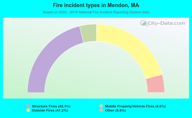 When looking into fire subcategories, the most reports belonged to: Structure Fires (42.3%), and Outside Fires (41.2%).
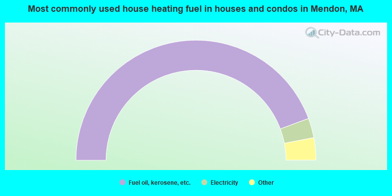
- 88.6%Fuel oil, kerosene, etc.
- 5.3%Electricity
- 3.1%Utility gas
- 1.5%Wood
- 0.6%Other fuel
- 0.4%Bottled, tank, or LP gas
- 0.4%Coal or coke
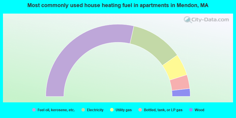
- 57.1%Fuel oil, kerosene, etc.
- 23.5%Electricity
- 9.7%Utility gas
- 6.2%Bottled, tank, or LP gas
- 3.5%Wood
Mendon compared to Massachusetts state average:
- Unemployed percentage significantly below state average.
- Black race population percentage significantly below state average.
- Hispanic race population percentage significantly below state average.
- Foreign-born population percentage significantly below state average.
- Renting percentage significantly below state average.
- Length of stay since moving in significantly above state average.
- Number of rooms per house significantly below state average.
- House age significantly below state average.
Mendon on our top lists:
- #5 on the list of "Top 101 cities with largest percentage of females in industries: professional and commercial equipment and supplies merchant wholesalers (population 5,000+)"
- #7 on the list of "Top 101 cities with largest percentage of males in industries: professional and commercial equipment and supplies merchant wholesalers (population 5,000+)"
- #16 on the list of "Top 101 cities with largest percentage of males in occupations: other sales and related workers including supervisors (population 5,000+)"
- #16 on the list of "Top 101 cities with largest percentage of females in industries: retail florists (population 5,000+)"
- #26 on the list of "Top 101 cities with largest percentage of males in industries: music stores (population 5,000+)"
- #46 on the list of "Top 101 cities with largest percentage of females in industries: office supplies and stationery stores (population 5,000+)"
- #47 on the list of "Top 101 cities with largest percentage of males in industries: computer and electronic products (population 5,000+)"
- #47 on the list of "Top 101 cities with largest percentage of males in industries: jewelry, luggage, and leather goods stores (population 5,000+)"
- #47 on the list of "Top 101 cities with largest percentage of males in industries: office supplies and stationery stores (population 5,000+)"
- #48 on the list of "Top 101 cities with largest percentage of females in occupations: other health diagnosing and treating practitioners and technical occupations (population 5,000+)"
- #51 on the list of "Top 101 cities with largest percentage of females in occupations: supervisors of transportation and material moving workers (population 5,000+)"
- #55 on the list of "Top 101 cities with largest percentage of females in occupations: food processing workers (population 5,000+)"
- #56 on the list of "Top 101 cities with largest percentage of males in occupations: advertising, marketing, promotions, public relations, and sales managers (population 5,000+)"
- #67 on the list of "Top 101 cities with largest percentage of males in industries: machinery, equipment, and supplies merchant wholesalers (population 5,000+)"
- #71 on the list of "Top 101 cities with largest percentage of females in occupations: operations specialties managers except financial managers (population 5,000+)"
- #85 on the list of "Top 101 cities with the most people driving a car to work alone (population 5,000+)"
- #91 on the list of "Top 101 cities with largest percentage of males in industries: social assistance (population 5,000+)"
- #92 on the list of "Top 101 cities with largest percentage of males in industries: building material and garden equipment and supplies dealers (population 5,000+)"
- #4 on the list of "Top 101 counties with the highest carbon monoxide air pollution readings in 2012 (ppm)"
- #5 on the list of "Top 101 counties with the most Catholic congregations"
- #12 on the list of "Top 101 counties with the highest surface withdrawal of fresh water for public supply"
- #16 on the list of "Top 101 counties with the highest total withdrawal of fresh water for public supply"
- #23 on the list of "Top 101 counties with the highest Sulfur Oxides Annual air pollution readings in 2012 (µg/m3)"
State forum archive:

|
|
Total of 288 patent applications in 2008-2024.