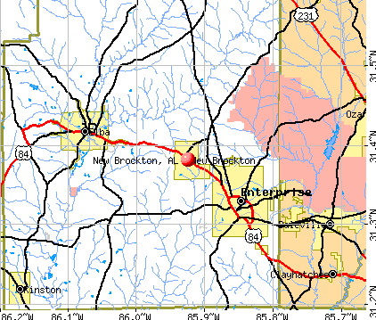
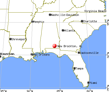
New Brockton, Alabama
Submit your own pictures of this town and show them to the world
- OSM Map
- General Map
- Google Map
- MSN Map
Population change since 2000: +18.2%
 |
| Males: 692 | |
| Females: 786 |
| Median resident age: | 43.5 years |
| Alabama median age: | 39.6 years |
Zip codes: 36351.
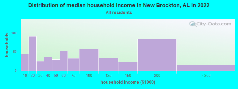
| New Brockton: | $54,703 |
| AL: | $59,674 |
Estimated per capita income in 2022: $29,991 (it was $13,018 in 2000)
New Brockton town income, earnings, and wages data
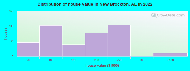
Estimated median house or condo value in 2022: $176,711 (it was $49,300 in 2000)
| New Brockton: | $176,711 |
| AL: | $200,900 |
Mean prices in 2022: all housing units: $158,252; detached houses: $172,585; mobile homes: $64,312
Median gross rent in 2022: $577.
(11.6% for White Non-Hispanic residents, 30.2% for Black residents, 71.3% for Hispanic or Latino residents, 78.8% for other race residents, 12.2% for two or more races residents)
Detailed information about poverty and poor residents in New Brockton, AL
Compare current foreclosures near New Brockton, AL:
| Photo | Address | Area | Beds / Baths | Price | Details |
|---|---|---|---|---|---|

|
#1
County Road 685
New Brockton, AL 36351
|
1,716 sq. feet
|
2 baths 4 beds |
$42,500
|
show details |

|
#2
Private Road 1206
New Brockton, AL 36351
|
1,873 sq. feet
|
2 baths - beds |
show details | |

|
#3
Highway 51
New Brockton, AL 36351
|
- sq. feet
|
- baths - beds |
show details | |

|
#4
County Road 520
New Brockton, AL 36351
|
- sq. feet
|
- baths - beds |
show details | |

|
#5
Highway 84
New Brockton, AL 36351
|
- sq. feet
|
- baths - beds |
show details | |

|
#6
County Road 520
New Brockton, AL 36351
|
- sq. feet
|
- baths - beds |
show details | |

|
#7
Fitzsimmons St # A
New Brockton, AL 36351
|
- sq. feet
|
- baths - beds |
show details | |

|
#8
N Metcalf St
New Brockton, AL 36351
|
- sq. feet
|
- baths - beds |
show details | |

|
#9
Mayberry Way
New Brockton, AL 36351
|
- sq. feet
|
- baths - beds |
show details | |

|
#10
N John St
New Brockton, AL 36351
|
- sq. feet
|
- baths - beds |
show details |
| Photo | Address | Area | Beds / Baths | Price | Details |
|---|---|---|---|---|---|

|
#11
W Mckinnon St
New Brockton, AL 36351
|
- sq. feet
|
- baths - beds |
show details | |

|
#12
County Road 258
New Brockton, AL 36351
|
- sq. feet
|
- baths - beds |
show details | |

|
#13
County Road 625
New Brockton, AL 36351
|
- sq. feet
|
- baths - beds |
show details | |

|
#14
County Road 148
New Brockton, AL 36351
|
1,040 sq. feet
|
- baths - beds |
show details | |

|
#15
Clay St
New Brockton, AL 36351
|
1,100 sq. feet
|
- baths - beds |
show details | |

|
#16
S John St
New Brockton, AL 36351
|
- sq. feet
|
- baths - beds |
show details | |

|
#17
Highway 167
New Brockton, AL 36351
|
- sq. feet
|
- baths - beds |
show details | |

|
#18
S Tyler St
New Brockton, AL 36351
|
- sq. feet
|
- baths - beds |
show details | |

|
#19
Taylor Ave
Elba, AL 36323
|
1,549 sq. feet
|
2 baths 2 beds |
$31,750
|
show details |

|
#20
County Road 625
New Brockton, AL 36351
|
- sq. feet
|
- baths - beds |
show details |
| Photo | Address | Area | Beds / Baths | Price | Details |
|---|---|---|---|---|---|

|
#21
Private Road 1100
New Brockton, AL 36351
|
- sq. feet
|
- baths - beds |
show details | |

|
#22
County Road 685
New Brockton, AL 36351
|
- sq. feet
|
- baths - beds |
show details | |

|
#23
S Ouida St
Enterprise, AL 36330
|
2,092 sq. feet
|
2 baths 3 beds |
show details | |

|
#24
Ladd St
Enterprise, AL 36330
|
1,651 sq. feet
|
2 baths 3 beds |
show details | |

|
#25
Auburn Dr
Enterprise, AL 36330
|
1,560 sq. feet
|
2 baths 3 beds |
show details | |

|
#26
County Road 315
Elba, AL 36323
|
900 sq. feet
|
1 baths 2 beds |
show details | |

|
#27
County Road 460
Samson, AL 36477
|
6,990 sq. feet
|
3 baths 5 beds |
show details | |

|
#28
Hwy 27
Ozark, AL 36360
|
1,754 sq. feet
|
2 baths 3 beds |
show details | |

|
#29
Highland Dr
Enterprise, AL 36330
|
1,791 sq. feet
|
2 baths - beds |
show details | |

|
#30
Forest Ave
Elba, AL 36323
|
1,569 sq. feet
|
2 baths - beds |
show details |
| Photo | Address | Area | Beds / Baths | Price | Details |
|---|---|---|---|---|---|

|
#31
Seminole Dr
Enterprise, AL 36330
|
- sq. feet
|
3 baths 4 beds |
show details | |

|
#32
Ladd St
Enterprise, AL 36330
|
1,479 sq. feet
|
1 baths - beds |
show details | |

|
#33
Piedmont Pl
Enterprise, AL 36330
|
3,351 sq. feet
|
2 baths - beds |
show details | |

|
#34
Key Bend Dr
Enterprise, AL 36330
|
1,712 sq. feet
|
1 baths - beds |
show details | |

|
#35
Liveoak Dr
Enterprise, AL 36330
|
1,440 sq. feet
|
1 baths - beds |
show details | |

|
#36
Natchez Rd
Enterprise, AL 36330
|
1,531 sq. feet
|
1 baths - beds |
show details | |

|
#37
Dixie Dr
Enterprise, AL 36330
|
1,401 sq. feet
|
1 baths - beds |
show details | |

|
#38
Comanche Ct
Enterprise, AL 36330
|
1,554 sq. feet
|
1 baths - beds |
show details | |

|
#39
Iroquois Rd
Enterprise, AL 36330
|
714 sq. feet
|
1 baths - beds |
show details | |

|
#40
W Hildreth Ave
Enterprise, AL 36330
|
1,591 sq. feet
|
1 baths - beds |
show details |
| Photo | Address | Area | Beds / Baths | Price | Details |
|---|---|---|---|---|---|

|
#41
Highland Dr
Enterprise, AL 36330
|
3,459 sq. feet
|
1 baths - beds |
show details | |

|
#42
Glenn St
Enterprise, AL 36330
|
1,626 sq. feet
|
1 baths - beds |
show details | |

|
#43
Rosewood Dr
Enterprise, AL 36330
|
2,098 sq. feet
|
1 baths - beds |
show details | |

|
#44
Hallhill Ct
Enterprise, AL 36330
|
1,905 sq. feet
|
1 baths - beds |
show details | |

|
#45
Omega Cir
Enterprise, AL 36330
|
1,338 sq. feet
|
1 baths - beds |
show details | |

|
#46
Highland Dr
Enterprise, AL 36330
|
825 sq. feet
|
1 baths - beds |
show details | |

|
#47
Crawford Ave
Enterprise, AL 36330
|
1,620 sq. feet
|
1 baths - beds |
show details | |

|
#48
Alabama St
Enterprise, AL 36330
|
1,498 sq. feet
|
1 baths - beds |
show details | |

|
#49
Frisco Ln
Enterprise, AL 36330
|
2,426 sq. feet
|
1 baths - beds |
show details | |

|
Check over 1 million property listings on Foreclosure.com!
|
browse all offers | |||


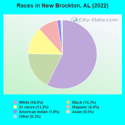
- 75858.6%White alone
- 23718.3%Black alone
- 17113.2%Two or more races
- 1219.4%Hispanic
- 231.8%American Indian alone
- 60.5%Asian alone
- 40.3%Other race alone
According to our research of Alabama and other state lists, there were 18 registered sex offenders living in New Brockton, Alabama as of April 27, 2024.
The ratio of all residents to sex offenders in New Brockton is 71 to 1.
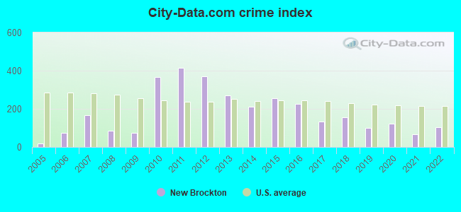
Type |
2009 |
2010 |
2011 |
2012 |
2013 |
2014 |
2015 |
2016 |
2017 |
2018 |
2019 |
2020 |
2021 |
2022 |
|---|---|---|---|---|---|---|---|---|---|---|---|---|---|---|
| Murders (per 100,000) | 0 (0.0) | 0 (0.0) | 0 (0.0) | 0 (0.0) | 0 (0.0) | 0 (0.0) | 1 (86.8) | 0 (0.0) | 0 (0.0) | 0 (0.0) | 0 (0.0) | 0 (0.0) | 0 (0.0) | 0 (0.0) |
| Rapes (per 100,000) | 0 (0.0) | 0 (0.0) | 0 (0.0) | 0 (0.0) | 0 (0.0) | 1 (86.8) | 0 (0.0) | 0 (0.0) | 0 (0.0) | 1 (84.7) | 0 (0.0) | 1 (78.4) | 0 (0.0) | 0 (0.0) |
| Robberies (per 100,000) | 0 (0.0) | 2 (174.5) | 3 (260.4) | 0 (0.0) | 0 (0.0) | 0 (0.0) | 0 (0.0) | 1 (86.1) | 0 (0.0) | 0 (0.0) | 0 (0.0) | 1 (78.4) | 0 (0.0) | 0 (0.0) |
| Assaults (per 100,000) | 0 (0.0) | 10 (872.6) | 9 (781.2) | 8 (686.7) | 5 (428.8) | 0 (0.0) | 0 (0.0) | 2 (172.3) | 1 (86.3) | 1 (84.7) | 1 (82.1) | 0 (0.0) | 1 (76.9) | 2 (137.6) |
| Burglaries (per 100,000) | 7 (567.7) | 14 (1,222) | 17 (1,476) | 21 (1,803) | 18 (1,544) | 9 (781.2) | 7 (607.6) | 14 (1,206) | 8 (690.3) | 6 (508.5) | 4 (328.4) | 3 (235.3) | 2 (153.7) | 5 (344.1) |
| Thefts (per 100,000) | 11 (892.1) | 12 (1,047) | 16 (1,389) | 23 (1,974) | 20 (1,715) | 23 (1,997) | 9 (781.2) | 20 (1,723) | 14 (1,208) | 10 (847.5) | 10 (821.0) | 2 (156.9) | 13 (999.2) | 13 (894.7) |
| Auto thefts (per 100,000) | 0 (0.0) | 2 (174.5) | 3 (260.4) | 4 (343.3) | 1 (85.8) | 1 (86.8) | 1 (86.8) | 2 (172.3) | 3 (258.8) | 0 (0.0) | 4 (328.4) | 2 (156.9) | 0 (0.0) | 3 (206.5) |
| Arson (per 100,000) | 0 (0.0) | 0 (0.0) | 0 (0.0) | 0 (0.0) | 0 (0.0) | 0 (0.0) | 0 (0.0) | 1 (86.1) | 0 (0.0) | 0 (0.0) | 0 (0.0) | 0 (0.0) | 0 (0.0) | 0 (0.0) |
| City-Data.com crime index | 75.4 | 368.2 | 414.1 | 370.0 | 269.3 | 210.9 | 254.3 | 227.4 | 134.6 | 154.2 | 98.5 | 121.6 | 66.1 | 103.9 |
The City-Data.com crime index weighs serious crimes and violent crimes more heavily. Higher means more crime, U.S. average is 246.1. It adjusts for the number of visitors and daily workers commuting into cities.
Crime rate in New Brockton detailed stats: murders, rapes, robberies, assaults, burglaries, thefts, arson
Full-time law enforcement employees in 2021, including police officers: 2 (2 officers - 2 male; 0 female).
| Officers per 1,000 residents here: | 1.54 |
| Alabama average: | 2.40 |
 Recent articles from our blog. Our writers, many of them Ph.D. graduates or candidates, create easy-to-read articles on a wide variety of topics.

 | Elba/New Brockton areas - tornadoes?? (9 replies) |
| new Brockton? (5 replies) |
| Moving to Fort Rucker (56 replies) |
| Visiting Enterprise Alabama next month (11 replies) |
| Moving to Enterprise, Alabama (13 replies) |
| Enterprise Alabama (3 replies) |
Latest news from New Brockton, AL collected exclusively by city-data.com from local newspapers, TV, and radio stations
Ancestries: American (14.2%), English (9.1%), Irish (7.6%), German (1.9%), African (1.9%), Scotch-Irish (1.6%).
Current Local Time: CST time zone
Elevation: 450 feet
Land area: 7.99 square miles.
Population density: 185 people per square mile (very low).
30 residents are foreign born (1.2% Latin America, 0.6% Europe, 0.5% Asia).
| This town: | 2.3% |
| Alabama: | 3.5% |
Median real estate property taxes paid for housing units with mortgages in 2022: $708 (0.4%)
Median real estate property taxes paid for housing units with no mortgage in 2022: $548 (0.5%)
Nearest city with pop. 50,000+: Dothan, AL  (32.4 miles , pop. 57,737).
Nearest city with pop. 200,000+: Montgomery, AL (70.9 miles , pop. 201,568).
Nearest city with pop. 1,000,000+: Houston, TX (574.1 miles , pop. 1,953,631).
Nearest cities:
), ), ), ), )Latitude: 31.38 N, Longitude: 85.92 W
Area code: 334
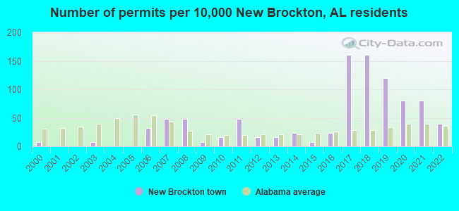
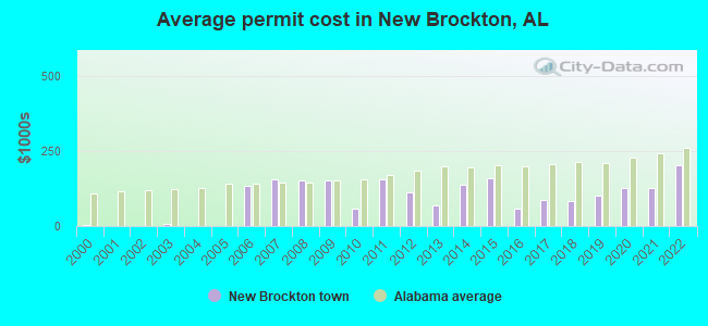
Single-family new house construction building permits:
- 2022: 5 buildings, average cost: $202,800
- 2021: 10 buildings, average cost: $127,800
- 2020: 10 buildings, average cost: $127,800
- 2019: 15 buildings, average cost: $100,000
- 2018: 20 buildings, average cost: $82,300
- 2017: 20 buildings, average cost: $87,200
- 2016: 3 buildings, average cost: $57,600
- 2015: 1 building, cost: $160,000
- 2014: 3 buildings, average cost: $136,300
- 2013: 2 buildings, average cost: $70,000
- 2012: 2 buildings, average cost: $112,000
- 2011: 6 buildings, average cost: $156,800
- 2010: 2 buildings, average cost: $59,000
- 2009: 1 building, cost: $149,600
- 2008: 6 buildings, average cost: $149,600
- 2007: 6 buildings, average cost: $153,500
- 2006: 4 buildings, average cost: $133,800
- 2003: 1 building, cost: $6,000
- 2000: 1 building, cost: $5,000
| Here: | 2.8% |
| Alabama: | 2.6% |
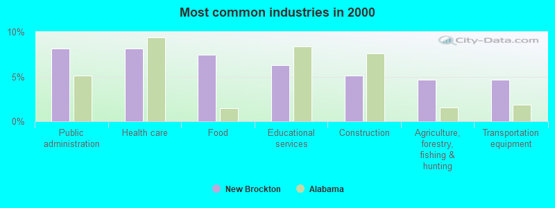
- Public administration (8.2%)
- Health care (8.2%)
- Food (7.5%)
- Educational services (6.3%)
- Construction (5.1%)
- Agriculture, forestry, fishing & hunting (4.7%)
- Transportation equipment (4.7%)
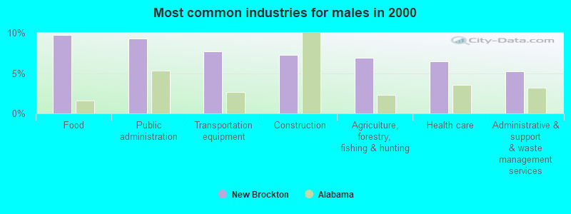
- Food (9.7%)
- Public administration (9.3%)
- Transportation equipment (7.7%)
- Construction (7.3%)
- Agriculture, forestry, fishing & hunting (6.9%)
- Health care (6.5%)
- Administrative & support & waste management services (5.3%)
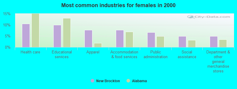
- Health care (10.4%)
- Educational services (9.9%)
- Apparel (7.7%)
- Accommodation & food services (7.7%)
- Public administration (6.6%)
- Social assistance (4.9%)
- Department & other general merchandise stores (4.9%)
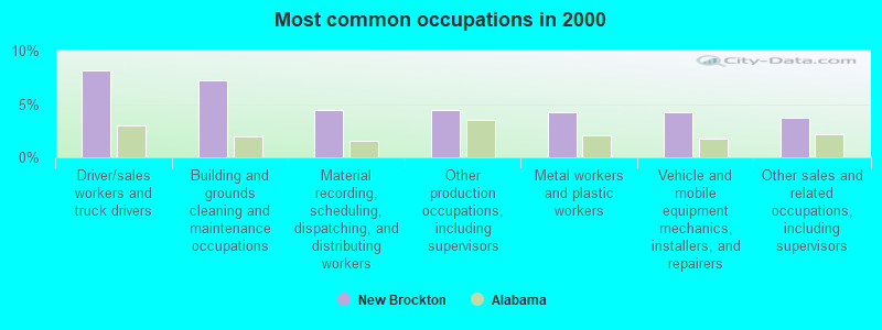
- Driver/sales workers and truck drivers (8.2%)
- Building and grounds cleaning and maintenance occupations (7.2%)
- Material recording, scheduling, dispatching, and distributing workers (4.4%)
- Other production occupations, including supervisors (4.4%)
- Metal workers and plastic workers (4.2%)
- Vehicle and mobile equipment mechanics, installers, and repairers (4.2%)
- Other sales and related occupations, including supervisors (3.7%)
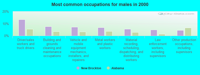
- Driver/sales workers and truck drivers (13.4%)
- Building and grounds cleaning and maintenance occupations (7.7%)
- Vehicle and mobile equipment mechanics, installers, and repairers (7.3%)
- Metal workers and plastic workers (6.9%)
- Material recording, scheduling, dispatching, and distributing workers (5.7%)
- Law enforcement workers, including supervisors (4.9%)
- Other production occupations, including supervisors (4.5%)
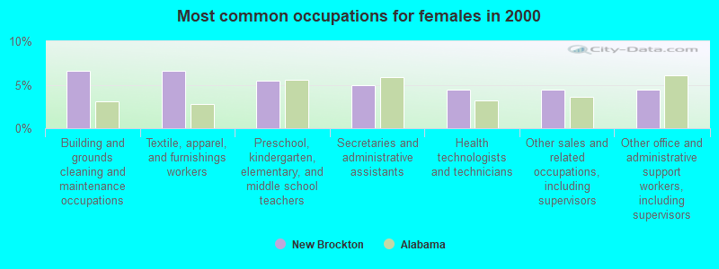
- Building and grounds cleaning and maintenance occupations (6.6%)
- Textile, apparel, and furnishings workers (6.6%)
- Preschool, kindergarten, elementary, and middle school teachers (5.5%)
- Secretaries and administrative assistants (4.9%)
- Health technologists and technicians (4.4%)
- Other sales and related occupations, including supervisors (4.4%)
- Other office and administrative support workers, including supervisors (4.4%)
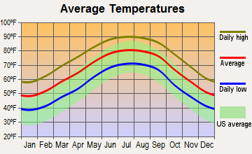
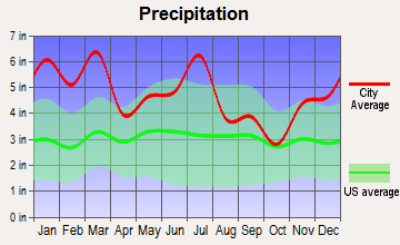
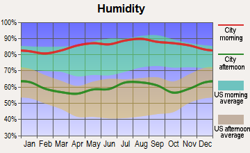
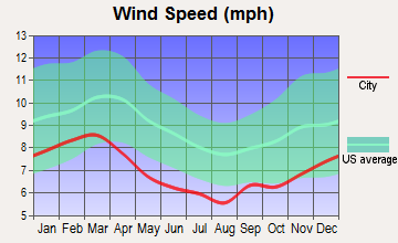
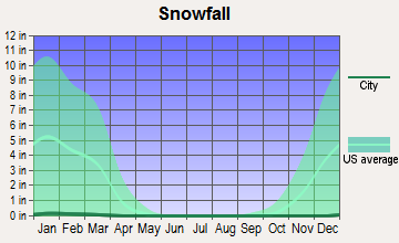
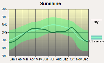
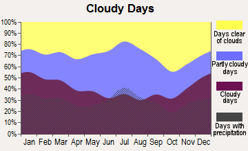
Average climate in New Brockton, Alabama
Based on data reported by over 4,000 weather stations
|
|

Tornado activity:
New Brockton-area historical tornado activity is slightly below Alabama state average. It is 50% greater than the overall U.S. average.
On 3/1/2007, a category F4 (max. wind speeds 207-260 mph) tornado 7.0 miles away from the New Brockton town center killed 9 people and injured 50 people and caused $250 million in damages.
On 5/16/1983, a category F3 (max. wind speeds 158-206 mph) tornado 0.3 miles away from the town center injured one person and caused between $50,000 and $500,000 in damages.
Earthquake activity:
New Brockton-area historical earthquake activity is significantly above Alabama state average. It is 23% greater than the overall U.S. average.On 10/24/1997 at 08:35:17, a magnitude 4.9 (4.8 MB, 4.2 MS, 4.9 LG, Depth: 6.2 mi, Class: Light, Intensity: IV - V) earthquake occurred 81.7 miles away from New Brockton center
On 1/18/1999 at 07:00:53, a magnitude 4.8 (4.8 MB, 4.0 LG, Depth: 0.6 mi) earthquake occurred 160.1 miles away from the city center
On 4/29/2003 at 08:59:39, a magnitude 4.9 (4.4 MB, 4.6 MW, 4.9 LG) earthquake occurred 216.0 miles away from the city center
On 11/7/2004 at 11:20:21, a magnitude 4.3 (4.3 MW, Depth: 3.1 mi) earthquake occurred 146.9 miles away from New Brockton center
On 8/2/1974 at 08:52:09, a magnitude 4.9 (4.3 MB, 4.9 LG) earthquake occurred 264.1 miles away from New Brockton center
On 6/24/1975 at 11:11:36, a magnitude 4.5 (4.5 MB) earthquake occurred 196.5 miles away from New Brockton center
Magnitude types: regional Lg-wave magnitude (LG), body-wave magnitude (MB), surface-wave magnitude (MS), moment magnitude (MW)
Natural disasters:
The number of natural disasters in Coffee County (23) is greater than the US average (15).Major Disasters (Presidential) Declared: 15
Emergencies Declared: 6
Causes of natural disasters: Storms: 12, Floods: 9, Hurricanes: 8, Tornadoes: 7, Winds: 4, Drought: 1, Snowfall: 1, Tropical Storm: 1, Winter Storm: 1, Other: 1 (Note: some incidents may be assigned to more than one category).
Hospitals and medical centers near New Brockton:
- DCI ENTERPRISE (Dialysis Facility, about 4 miles away; ENTERPRISE, AL)
- COFFEE COUNTY HOME CARE (Home Health Center, about 4 miles away; ENTERPRISE, AL)
- MEDICAL CENTER ENTERPRISE Acute Care Hospitals (about 6 miles away; ENTERPRISE, AL)
- COMMUNITY CARE HOSPICE INC (Hospital, about 7 miles away; ENTERPRISE, AL)
- DAVITA ENTERPRISE (Dialysis Facility, about 7 miles away; ENTERPRISE, AL)
- MID-SOUTH HOME HEALTH AGENCY, LLC (Home Health Center, about 7 miles away; ENTERPRISE, AL)
- SOUTHEAST ALABAMA HOMECARE (Home Health Center, about 7 miles away; ENTERPRISE, AL)
Heliports located in New Brockton:
See details about Heliports located in New Brockton, ALColleges/universities with over 2000 students nearest to New Brockton:
- Enterprise State Community College (about 8 miles; Enterprise, AL; Full-time enrollment: 2,101)
- George C Wallace State Community College-Dothan (about 28 miles; Dothan, AL; FT enrollment: 3,611)
- Troy University (about 30 miles; Troy, AL; FT enrollment: 16,148)
- Northwest Florida State College (about 67 miles; Niceville, FL; FT enrollment: 5,052)
- Auburn University at Montgomery (about 70 miles; Montgomery, AL; FT enrollment: 4,092)
- Alabama State University (about 72 miles; Montgomery, AL; FT enrollment: 5,457)
- Faulkner University (about 72 miles; Montgomery, AL; FT enrollment: 2,887)
Public high school in New Brockton:
- NEW BROCKTON HIGH SCH (Students: 384, Location: 210 SOUTH TYLER STREET, Grades: 7-12)
Private high school in New Brockton:
Public elementary/middle school in New Brockton:
- NEW BROCKTON ELEM SCH (Students: 379, Location: 504 NORTH JOHN STREET, Grades: PK-6)
Points of interest:
Notable location: New Brockton Volunteer Fire Department (A). Display/hide its location on the map
Churches in New Brockton include: Popular Springs Baptist Church (A), New Brockton United Methodist Church (B), Collins Chapel (C). Display/hide their locations on the map
Cemetery: New Brockton City Cemetery (1). Display/hide its location on the map
Birthplace of: Don Helms - Musician, John W. Brock - Navy Navy Cross recipient, Wayne Mixson - Soilder, Abdul Salaam (American football) - Football player.
Drinking water stations with addresses in New Brockton and their reported violations in the past:
COFFEE COUNTY WATER AUTHORITY (Population served: 3,789, Groundwater):Past health violations:NEW BROCKTON WATER DEPARTMENT (Population served: 3,297, Groundwater):
- MCL, Monthly (TCR) - In NOV-2008, Contaminant: Coliform. Follow-up actions: St Public Notif requested (DEC-11-2008), St Violation/Reminder Notice (DEC-11-2008), St Public Notif received (JAN-07-2009), St Compliance achieved (JUN-10-2009)
Past health violations:Past monitoring violations:
- MCL, Monthly (TCR) - In MAY-2009, Contaminant: Coliform. Follow-up actions: St Public Notif requested (JUN-17-2009), St Violation/Reminder Notice (JUN-17-2009), St Public Notif received (JUL-28-2009), St Compliance achieved (MAY-10-2010)
- Follow-up Or Routine LCR Tap M/R - In OCT-11-2003, Contaminant: Lead and Copper Rule. Follow-up actions: St Violation/Reminder Notice (NOV-03-2003), St Compliance achieved (JAN-17-2008)
- 2 minor monitoring violations
| This town: | 2.4 people |
| Alabama: | 2.5 people |
| This town: | 69.7% |
| Whole state: | 67.8% |
| This town: | 3.8% |
| Whole state: | 4.7% |
Likely homosexual households (counted as self-reported same-sex unmarried-partner households)
- Lesbian couples: 0.4% of all households
- Gay men: 0.0% of all households
Banks with branches in New Brockton (2011 data):
- Troy Bank & Trust Company: New Brockton Branch at 108 Mckinnon Street, branch established on 1969/03/05. Info updated 2008/09/24: Bank assets: $852.0 mil, Deposits: $714.4 mil, headquarters in Troy, AL, positive income, Commercial Lending Specialization, 9 total offices, Holding Company: Trust No. 3 Under The Will Of Charles Henderson
For population 15 years and over in New Brockton:
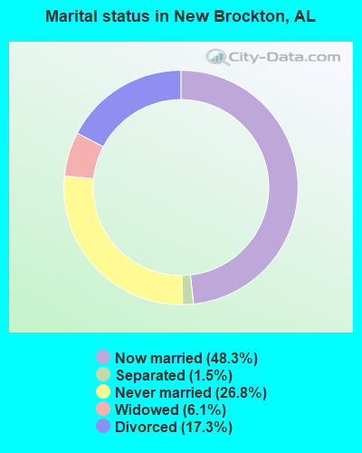
- Never married: 26.8%
- Now married: 48.3%
- Separated: 1.5%
- Widowed: 6.1%
- Divorced: 17.3%
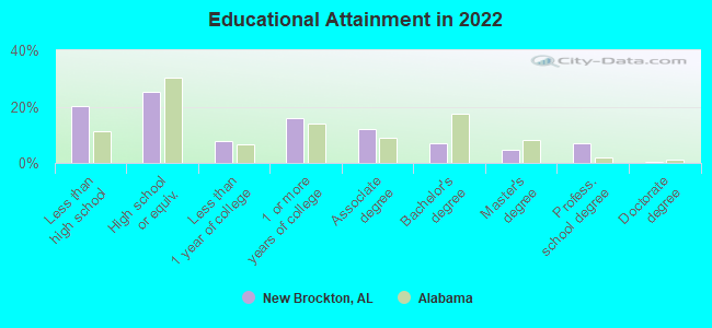
For population 25 years and over in New Brockton:
- High school or higher: 78.5%
- Bachelor's degree or higher: 17.3%
- Graduate or professional degree: 10.7%
- Unemployed: 7.7%
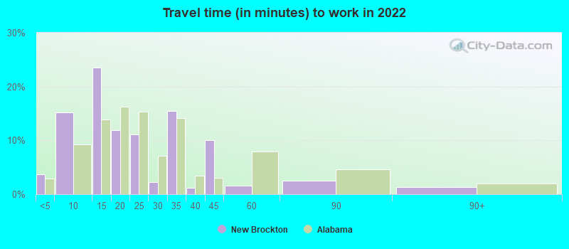
- Mean travel time to work (commute): 21.4 minutes
| Here: | 14.9 |
| Alabama average: | 11.5 |
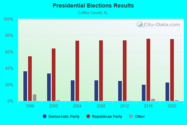
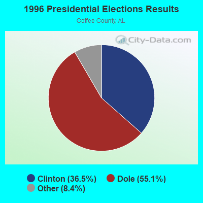
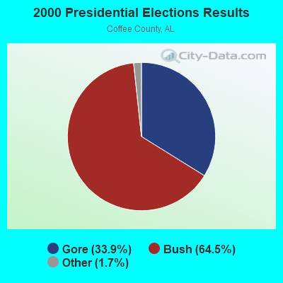

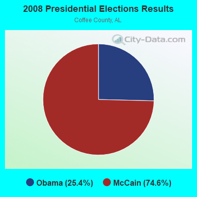
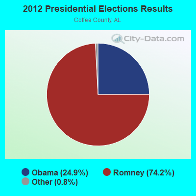


Graphs represent county-level data. Detailed 2008 Election Results
Religion statistics for New Brockton, AL (based on Coffee County data)
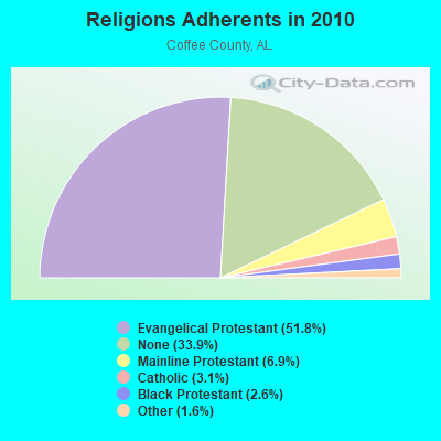
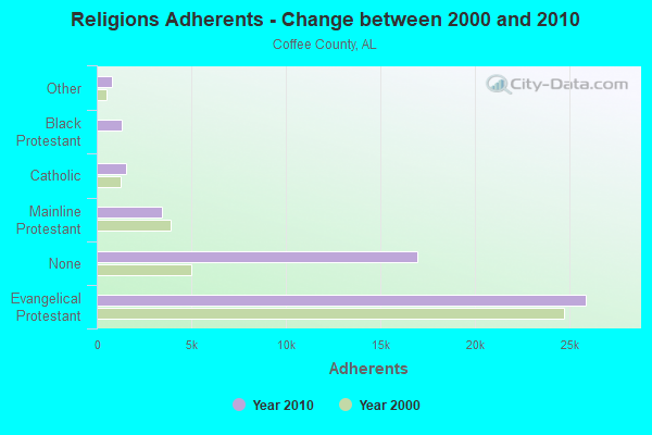
| Religion | Adherents | Congregations |
|---|---|---|
| Evangelical Protestant | 25,889 | 91 |
| Mainline Protestant | 3,457 | 13 |
| Catholic | 1,550 | 1 |
| Black Protestant | 1,320 | 11 |
| Other | 805 | 4 |
| None | 16,927 | - |
Food Environment Statistics:
| Coffee County: | 1.28 / 10,000 pop. |
| State: | 1.89 / 10,000 pop. |
| Coffee County: | 0.21 / 10,000 pop. |
| State: | 0.20 / 10,000 pop. |
| Coffee County: | 0.86 / 10,000 pop. |
| Alabama: | 0.65 / 10,000 pop. |
| This county: | 7.06 / 10,000 pop. |
| Alabama: | 6.32 / 10,000 pop. |
| This county: | 7.91 / 10,000 pop. |
| Alabama: | 5.75 / 10,000 pop. |
| Coffee County: | 10.8% |
| State: | 11.8% |
| This county: | 32.5% |
| Alabama: | 31.7% |
| Coffee County: | 16.6% |
| Alabama: | 13.5% |
Health and Nutrition:
| New Brockton: | 50.3% |
| Alabama: | 49.0% |
| This city: | 46.9% |
| Alabama: | 45.7% |
| This city: | 28.7 |
| Alabama: | 28.9 |
| This city: | 19.9% |
| Alabama: | 20.7% |
| New Brockton: | 10.4% |
| Alabama: | 11.0% |
| New Brockton: | 6.8 |
| Alabama: | 6.8 |
| This city: | 33.8% |
| Alabama: | 34.4% |
| Here: | 55.7% |
| Alabama: | 55.2% |
| New Brockton: | 79.5% |
| State: | 79.3% |
More about Health and Nutrition of New Brockton, AL Residents
| Local government employment and payroll (March 2022) | |||||
| Function | Full-time employees | Monthly full-time payroll | Average yearly full-time wage | Part-time employees | Monthly part-time payroll |
|---|---|---|---|---|---|
| Police Protection - Officers | 3 | $13,773 | $55,092 | 6 | $4,632 |
| Streets and Highways | 2 | $3,941 | $23,646 | 0 | $0 |
| Other Government Administration | 1 | $2,688 | $32,256 | 0 | $0 |
| Other and Unallocable | 1 | $4,765 | $57,180 | 1 | $988 |
| Financial Administration | 0 | $0 | 2 | $10,035 | |
| Totals for Government | 7 | $25,167 | $43,143 | 9 | $15,655 |
New Brockton government finances - Expenditure in 2017 (per resident):
- Current Operations - Police Protection: $95,000 ($64.28)
Central Staff Services: $79,000 ($53.45)
Regular Highways: $69,000 ($46.68)
Solid Waste Management: $68,000 ($46.01)
Financial Administration: $10,000 ($6.77)
Health - Other: $6,000 ($4.06)
Judicial and Legal Services: $2,000 ($1.35)
- Total Salaries and Wages: $102,000 ($69.01)
New Brockton government finances - Revenue in 2017 (per resident):
- Charges - Solid Waste Management: $90,000 ($60.89)
- Miscellaneous - General Revenue - Other: $19,000 ($12.86)
Rents: $7,000 ($4.74)
- Tax - General Sales and Gross Receipts: $217,000 ($146.82)
Public Utilities Sales: $65,000 ($43.98)
Occupation and Business License - Other: $49,000 ($33.15)
Property: $37,000 ($25.03)
Motor Fuels Sales: $25,000 ($16.91)
Alcoholic Beverage Sales: $9,000 ($6.09)
Tobacco Products Sales: $7,000 ($4.74)
Motor Vehicle License: $3,000 ($2.03)
New Brockton government finances - Cash and Securities in 2017 (per resident):
- Other Funds - Cash and Securities: $231,000 ($156.29)
10.82% of this county's 2021 resident taxpayers lived in other counties in 2020 ($53,280 average adjusted gross income)
| Here: | 10.82% |
| Alabama average: | 6.87% |
0.18% of residents moved from foreign countries ($1,154 average AGI)
Coffee County: 0.18% Alabama average: 0.02%
Top counties from which taxpayers relocated into this county between 2020 and 2021:
| from Dale County, AL | |
| from Houston County, AL | |
| from Geneva County, AL |
10.45% of this county's 2020 resident taxpayers moved to other counties in 2021 ($53,500 average adjusted gross income)
| Here: | 10.45% |
| Alabama average: | 6.41% |
0.21% of residents moved to foreign countries ($1,557 average AGI)
Coffee County: 0.21% Alabama average: 0.02%
Top counties to which taxpayers relocated from this county between 2020 and 2021:
| to Dale County, AL | |
| to Houston County, AL | |
| to Geneva County, AL |
Strongest AM radio stations in New Brockton:
- WQLS (1200 AM; 10 kW; OZARK, AL; Owner: STYLES BROADCASTING OF DOTHAN, INC.)
- WTKN (1560 AM; daytime; 5 kW; DALEVILLE, AL; Owner: JOSEPH A. ADAMS, SR.)
- WELB (1350 AM; 1 kW; ELBA, AL; Owner: ELBA RADIO COMPANY)
- WOOF (560 AM; 5 kW; DOTHAN, AL; Owner: WOOF, INC.)
- WOPP (1290 AM; 2 kW; OPP, AL; Owner: E. & R BROADCASTING, INC.)
- WTBF (970 AM; 5 kW; TROY, AL; Owner: TROY BROADCASTING CORP.)
- WOZK (900 AM; 1 kW; OZARK, AL; Owner: OZARK B/CING. CORP.)
- WASG (550 AM; 25 kW; ATMORE, AL; Owner: 550 AM, INC)
- WZEP (1460 AM; 10 kW; DEFUNIAK SPRINGS, FL; Owner: WALTON COUNTY BROADCASTING, INC.)
- WJOX (690 AM; 50 kW; BIRMINGHAM, AL; Owner: CITADEL BROADCASTING COMPANY)
- WAMI (860 AM; 1 kW; OPP, AL; Owner: THE OPP BROADCASTING CO., INC.)
- WSTT (730 AM; 25 kW; THOMASVILLE, GA; Owner: MARION R. WILLIAMS)
- WMSP (740 AM; 10 kW; MONTGOMERY, AL; Owner: CUMULUS LICENSING CORP.)
Strongest FM radio stations in New Brockton:
- WKMX (106.7 FM; ENTERPRISE, AL; Owner: WKMX, INC.)
- WZTZ (101.1 FM; ELBA, AL; Owner: ELBA RADIO COMPANY)
- WDJR (96.9 FM; ENTERPRISE, AL; Owner: GULF SOUTH COMMUNICATIONS, INC.)
- WRJM-FM (93.7 FM; GENEVA, AL; Owner: STAGE DOOR DEVELOPMENT, INC.)
- WQLD (104.3 FM; LUVERNE, AL; Owner: CAPSTAR TX LIMITED PARTNERSHIP)
- WZHT (105.7 FM; TROY, AL; Owner: CAPSTAR TX LIMITED PARTNERSHIP)
- WDYF (90.3 FM; DOTHAN, AL; Owner: FAITH BROADCASTING, INC.)
- WXUS (100.5 FM; FORT RUCKER, AL; Owner: SKYWAY BROADCASTING, LTD.)
- WOOF-FM (99.7 FM; DOTHAN, AL; Owner: WOOF, INC.)
- WTVY-FM (95.5 FM; DOTHAN, AL; Owner: STYLES BROADCASTING OF DOTHAN, INC.)
- WRWA (88.7 FM; DOTHAN, AL; Owner: TROY STATE UNIVERSITY)
- WOAB (104.9 FM; OZARK, AL; Owner: OZARK BROADCASTING CORPORATION)
- WTBF-FM (94.7 FM; BRUNDIDGE, AL; Owner: TROY BROADCASTING CORPORATION)
- WAQG (91.7 FM; OZARK, AL; Owner: AMERICAN FAMILY ASSOCIATION)
- WAXU (91.1 FM; TROY, AL; Owner: AMERICAN FAMILY ASSOCIATION)
- WAMI-FM (102.3 FM; OPP, AL; Owner: THE OPP BROADCASTING CO., INC.)
- WJRL-FM (103.9 FM; OZARK, AL; Owner: STYLES BROADCASTING OF DOTHAN, INC.)
TV broadcast stations around New Brockton:
- WTVY (Channel 4; DOTHAN, AL; Owner: GRAY MIDAMERICA TV LICENSEE CORP.)
- WDIQ (Channel 2; DOZIER, AL; Owner: ALABAMA EDUCATIONAL TELEVISION COMMISSION)
- WDFX-TV (Channel 34; OZARK, AL; Owner: WAITT LICENSE CO. OF ALABAMA, L.L.C.)
- WRJM-TV (Channel 67; TROY, AL; Owner: JOSIE PARK BROADCASTING, INC.)
- WSFA (Channel 12; MONTGOMERY, AL; Owner: LIBCO, INC.)
- WCOV-TV (Channel 20; MONTGOMERY, AL; Owner: WOODS COMMUNICATIONS CORPORATION)
- WGIQ (Channel 43; LOUISVILLE, AL; Owner: ALABAMA EDUCATIONAL TELEVISION COMMISSION)
New Brockton fatal accident list:
Sep 9, 2011 06:10 PM, Us-Sr 12, Lat: 31.367994, Lon: -85.898231, Vehicles: 1, Persons: 1, Fatalities: 1
Jul 3, 2010 10:10 PM, Us-Sr 12, Lat: 31.374928, Lon: -85.915372, Vehicles: 1, Persons: 1, Fatalities: 1, Drunk persons involved: 1
May 8, 1995 02:45 PM, Sr12, Vehicles: 2, Persons: 2, Fatalities: 1
Jan 28, 1994 12:00 AM, Sr12, Vehicles: 2, Persons: 4, Fatalities: 1
Dec 7, 1994 08:35 PM, 122, Vehicles: 2, Persons: 4, Fatalities: 1, Drunk persons involved: 1
- National Bridge Inventory (NBI) Statistics
- 5Number of bridges
- 98ft / 29.6mTotal length
- $12,216,000Total costs
- 11,532Total average daily traffic
- 715Total average daily truck traffic
- 15,645Total future (year 2030) average daily traffic
FCC Registered Antenna Towers:
25 (See the full list of FCC Registered Antenna Towers in New Brockton)FCC Registered Private Land Mobile Towers:
2- .5 Mi E (Lat: 31.388778 Lon: -85.922167), Type: Tower, Structure height: 146 m, Call Sign: WPFR731,
Assigned Frequencies: 859.287 MHz, 859.312 MHz, 859.337 MHz, 859.362 MHz, 859.387 MHz, 859.412 MHz, 859.787 MHz, 859.862 MHz, 859.887 MHz, 859.912 MHz... (+10 more), Grant Date: 07/30/2019, Expiration Date: 06/08/2029, Registrant: Southern Communications Services, Inc D/B/A Southern Linc, 600 18th St N Bin Sn-0800, Birmingham, AL 35203-2206, Phone: (205) 257-1534, Email:
- .5 Mi E (Lat: 31.388778 Lon: -85.922167), Type: Tower, Structure height: 146 m, Call Sign: WQJM759,
Assigned Frequencies: 855.412 MHz, Grant Date: 04/28/2009, Expiration Date: 06/08/2019, Cancellation Date: 05/21/2013, Certifier: Robin J Cohen, Registrant: Sprint Nextel Corporation, 12502 Sunrise Valley Drive, Reston, VA 20191, Phone: (703) 433-4000, Fax: (703) 433-4483
FCC Registered Broadcast Land Mobile Towers:
4- #8 County Complex (Lat: 31.377944 Lon: -85.914417), Type: Tower, Structure height: 92 m, Overall height: 97.5 m, Call Sign: KNGG942,
Assigned Frequencies: 453.400 MHz, 458.400 MHz, 453.425 MHz, 458.425 MHz, Grant Date: 03/10/2023, Expiration Date: 04/07/2033, Registrant: Alabama Emergency Management Agency, 5898 County Road 41, Clanton, AL 35046, Phone: (205) 280-2290, Fax: (386) 322-2502, Email:
- 202 S John St (Lat: 31.397389 Lon: -85.938833), Call Sign: KWX510,
Assigned Frequencies: 153.845 MHz, Grant Date: 10/04/2004, Expiration Date: 10/16/2014, Cancellation Date: 12/20/2014, Registrant: New Brockton Water Department, 202 S John St, New Brockton, AL 36351, Phone: (334) 894-5550
- 202 S John St (Lat: 31.397389 Lon: -85.938833), Call Sign: KBP764, Licensee ID: L00118800,
Assigned Frequencies: 155.010 MHz, 155.595 MHz, Grant Date: 01/07/1997, Expiration Date: 02/02/2002, Cancellation Date: 05/05/2002, Registrant: City Of New Brockton, New Brockton, AL 36351, Phone: (205) 894-5559
- Us 84 W (Lat: 31.408500 Lon: -85.936056), Call Sign: KIF720, Licensee ID: L00015940,
Assigned Frequencies: 35.9000 MHz, Grant Date: 05/21/2002, Expiration Date: 05/21/2012, Cancellation Date: 04/15/2009, Registrant: Propane Gas & Appliance Co Inc, New Brockton, AL 36351, Phone: (205) 894-5511
FCC Registered Microwave Towers:
5- DOTAL0084, 0.5 Miles East Of New Brockton (Lat: 31.388611 Lon: -85.921111), Type: Gtower, Structure height: 146.3 m, Overall height: 151.5 m, Call Sign: WQPK232,
Assigned Frequencies: 11265.0 MHz, 11305.0 MHz, 11305.0 MHz, 11305.0 MHz, 11305.0 MHz, 11305.0 MHz, 11305.0 MHz, 11305.0 MHz, Grant Date: 07/12/2022, Expiration Date: 06/11/2032, Certifier: Jeffrey R Strenkowski, Registrant: Southern Light, LLC, 107 St. Francis Street, Suite 1800, Mobile, AL 36602, Phone: (877) 652-2321, Email:
- New Brockton, 326 North John Street (Lat: 31.388611 Lon: -85.921111), Type: Gtower, Structure height: 146.3 m, Overall height: 151.5 m, Call Sign: WQPY535,
Assigned Frequencies: 11545.0 MHz, 11585.0 MHz, 11585.0 MHz, Grant Date: 08/16/2022, Expiration Date: 09/19/2032, Certifier: John E Monday, Registrant: At&t Services, Inc., 208 S Akard St, 20f, Dallas, TX 75202, Phone: (855) 699-7073, Email:
- NEWBROCKTON, 0.5 Miles East Of New Brockton (Lat: 31.388611 Lon: -85.921111), Type: Gtower, Structure height: 146.3 m, Overall height: 151.5 m, Call Sign: WQZB476,
Assigned Frequencies: 11385.0 MHz, 11425.0 MHz, 11465.0 MHz, 11505.0 MHz, 11385.0 MHz, 11425.0 MHz, 11465.0 MHz, 11505.0 MHz, 11385.0 MHz, 11425.0 MHz... (+22 more), Grant Date: 03/28/2017, Expiration Date: 03/28/2027, Certifier: Larry F Butts, Registrant: Southern Company Services, 600 N. 18th St / Bin 5n-5409, Birmingham, AL 35203, Phone: (205) 257-7600, Fax: (205) 257-2134, Email:
- NEW BROCKTON, 0.5 Miles East Of New Brockton (Lat: 31.388611 Lon: -85.921111), Type: Gtower, Structure height: 146.3 m, Overall height: 151.5 m, Call Sign: WRFJ350,
Assigned Frequencies: 11225.0 MHz, 11265.0 MHz, 11225.0 MHz, 11265.0 MHz, 11225.0 MHz, 11265.0 MHz, 11225.0 MHz, 11265.0 MHz, 11225.0 MHz, 11265.0 MHz, Grant Date: 03/13/2020, Expiration Date: 03/13/2030, Certifier: Laurie Gebhardt, Registrant: Cellco Partnership, 5055 North Point Pkwy, Np2ne Network Engineering, Alpharetta, GA 30022, Phone: (770) 797-1070, Email:
- CHICKEN RUN, 0 Highway 167 (15188971) (Lat: 31.456528 Lon: -85.896139), Type: Ltower, Structure height: 76.2 m, Overall height: 80.8 m, Call Sign: WRFJ355,
Assigned Frequencies: 10735.0 MHz, 10775.0 MHz, 10735.0 MHz, 10775.0 MHz, 10735.0 MHz, 10775.0 MHz, 10735.0 MHz, 10775.0 MHz, 10735.0 MHz, 10775.0 MHz, Grant Date: 03/13/2020, Expiration Date: 03/13/2030, Certifier: Laurie Gebhardt, Registrant: Cellco Partnership, 5055 North Point Pkwy, Np2ne Network Engineering, Alpharetta, GA 30022, Phone: (770) 797-1070, Email:
FCC Registered Amateur Radio Licenses:
17 (See the full list of FCC Registered Amateur Radio Licenses in New Brockton)FAA Registered Aircraft:
9 (See the full list of FAA Registered Aircraft in New Brockton)2002 - 2018 National Fire Incident Reporting System (NFIRS) incidents
- Fire incident types reported to NFIRS in New Brockton, AL
- 6844.7%Outside Fires
- 6341.4%Structure Fires
- 1610.5%Mobile Property/Vehicle Fires
- 53.3%Other
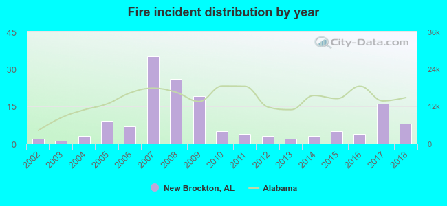 Based on the data from the years 2002 - 2018 the average number of fire incidents per year is 9. The highest number of reported fire incidents - 35 took place in 2007, and the least - 1 in 2003. The data has an increasing trend.
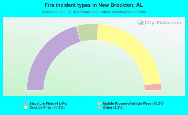 When looking into fire subcategories, the most reports belonged to: Outside Fires (44.7%), and Structure Fires (41.4%).
| Most common first names in New Brockton, AL among deceased individuals | ||
| Name | Count | Lived (average) |
|---|---|---|
| James | 44 | 71.5 years |
| John | 30 | 72.9 years |
| Mary | 25 | 77.8 years |
| William | 24 | 69.1 years |
| Annie | 14 | 77.7 years |
| Jessie | 14 | 78.7 years |
| Robert | 14 | 72.2 years |
| Willie | 13 | 74.3 years |
| George | 13 | 71.3 years |
| Charles | 9 | 68.2 years |
| Most common last names in New Brockton, AL among deceased individuals | ||
| Last name | Count | Lived (average) |
|---|---|---|
| Hornsby | 14 | 80.3 years |
| Maddox | 14 | 76.0 years |
| Johnson | 13 | 74.2 years |
| Smith | 13 | 73.4 years |
| Adkison | 12 | 72.8 years |
| Driggers | 12 | 70.7 years |
| Tindol | 12 | 80.4 years |
| Lindsey | 12 | 71.5 years |
| Helms | 12 | 75.7 years |
| Kelley | 12 | 76.1 years |
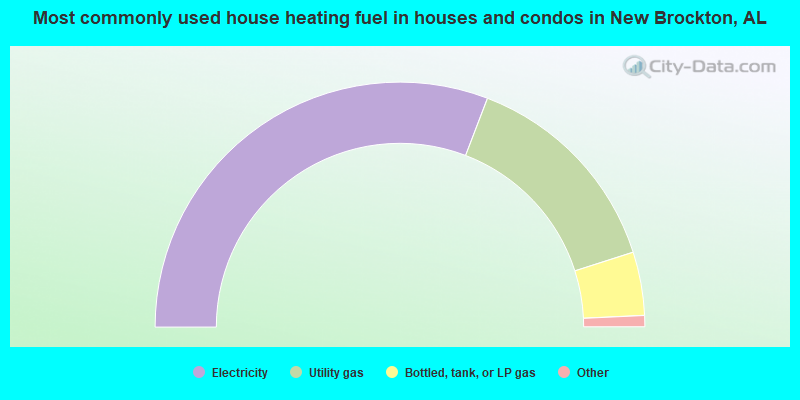
- 61.9%Electricity
- 28.6%Utility gas
- 8.4%Bottled, tank, or LP gas
- 0.5%Fuel oil, kerosene, etc.
- 0.5%No fuel used
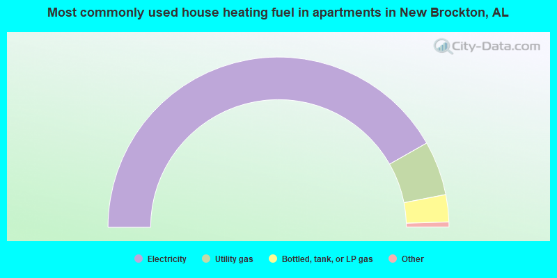
- 84.3%Electricity
- 10.4%Utility gas
- 5.2%Bottled, tank, or LP gas
New Brockton compared to Alabama state average:
- Unemployed percentage below state average.
- Hispanic race population percentage above state average.
- Median age below state average.
- Length of stay since moving in significantly below state average.
- Institutionalized population percentage significantly above state average.
- Number of college students significantly below state average.
New Brockton on our top lists:
- #48 on the list of "Top 101 cities with the largest percentage of people in local jails and other confinement facilities (including police lockups) (population 1,000+)"
- #19 on the list of "Top 101 counties with the highest percentage of residents relocating to foreign countries in 2011"
- #57 on the list of "Top 101 counties with the highest percentage of residents relocating from foreign countries between 2010 and 2011"
- #60 on the list of "Top 101 counties with the highest percentage of residents relocating to other counties in 2011"
- #71 on the list of "Top 101 counties with the highest percentage of residents relocating from other counties between 2010 and 2011"
State forum archive: