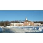
Shrewsbury, Massachusetts

Submit your own pictures of this town and show them to the world
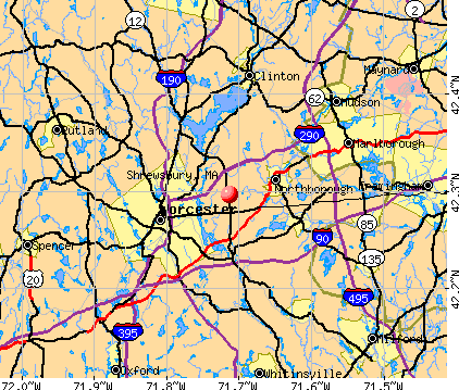
- OSM Map
- General Map
- Google Map
- MSN Map
Population change since 2000: +12.5%
 |
| Males: 17,365 | |
| Females: 18,243 |
| Median resident age: | 40.2 years |
| Massachusetts median age: | 39.2 years |
Zip codes: 01545.
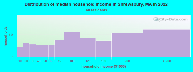
| Shrewsbury: | $115,740 |
| MA: | $94,488 |
Estimated per capita income in 2022: $61,555 (it was $31,570 in 2000)
Shrewsbury town income, earnings, and wages data
Estimated median house or condo value in 2022: $529,393 (it was $191,700 in 2000)
| Shrewsbury: | $529,393 |
| MA: | $534,700 |
Mean prices in 2022: all housing units: $419,164; detached houses: $447,621; townhouses or other attached units: $343,592; in 2-unit structures: $323,295; in 3-to-4-unit structures: $332,295; in 5-or-more-unit structures: $232,758; mobile homes: $113,885
Detailed information about poverty and poor residents in Shrewsbury, MA


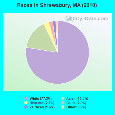
- 27,53477.3%White alone
- 5,44715.3%Asian alone
- 9612.7%Hispanic
- 7172.0%Black alone
- 5791.6%Two or more races
- 3380.9%Other race alone
- 270.08%American Indian alone
- 50.01%Native Hawaiian and Other
Pacific Islander alone
Races in Shrewsbury detailed stats: ancestries, foreign born residents, place of birth
According to our research of Massachusetts and other state lists, there were 3 registered sex offenders living in Shrewsbury, Massachusetts as of April 28, 2024.
The ratio of all residents to sex offenders in Shrewsbury is 11,869 to 1.
The ratio of registered sex offenders to all residents in this city is much lower than the state average.
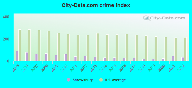
Type |
2009 |
2010 |
2011 |
2012 |
2013 |
2014 |
2015 |
2016 |
2017 |
2018 |
2019 |
2020 |
2021 |
2022 |
|---|---|---|---|---|---|---|---|---|---|---|---|---|---|---|
| Murders (per 100,000) | 0 (0.0) | 1 (2.8) | 0 (0.0) | 1 (2.8) | 0 (0.0) | 0 (0.0) | 0 (0.0) | 0 (0.0) | 0 (0.0) | 0 (0.0) | 0 (0.0) | 0 (0.0) | 1 (2.5) | 0 (0.0) |
| Rapes (per 100,000) | 2 (5.9) | 2 (5.6) | 0 (0.0) | 0 (0.0) | 0 (0.0) | 1 (2.7) | 0 (0.0) | 0 (0.0) | 1 (2.7) | 2 (5.3) | 1 (2.6) | 2 (5.2) | 3 (7.6) | 1 (2.5) |
| Robberies (per 100,000) | 3 (8.8) | 3 (8.4) | 3 (8.4) | 2 (5.5) | 2 (5.5) | 1 (2.7) | 1 (2.7) | 1 (2.7) | 2 (5.4) | 1 (2.7) | 2 (5.3) | 0 (0.0) | 3 (7.6) | 0 (0.0) |
| Assaults (per 100,000) | 2 (5.9) | 12 (33.7) | 2 (5.6) | 3 (8.3) | 4 (11.0) | 0 (0.0) | 3 (8.1) | 3 (8.1) | 5 (13.5) | 2 (5.3) | 1 (2.6) | 3 (7.8) | 4 (10.1) | 3 (7.5) |
| Burglaries (per 100,000) | 51 (150.2) | 85 (238.7) | 69 (192.6) | 75 (208.1) | 54 (148.7) | 52 (142.2) | 56 (152.1) | 47 (127.5) | 30 (81.1) | 12 (31.9) | 15 (39.5) | 7 (18.1) | 23 (58.1) | 27 (67.9) |
| Thefts (per 100,000) | 287 (845.2) | 217 (609.4) | 199 (555.5) | 189 (524.3) | 204 (561.8) | 152 (415.6) | 165 (448.1) | 115 (311.9) | 128 (346.2) | 98 (260.4) | 95 (250.1) | 125 (323.4) | 201 (507.6) | 207 (520.8) |
| Auto thefts (per 100,000) | 15 (44.2) | 15 (42.1) | 15 (41.9) | 13 (36.1) | 11 (30.3) | 5 (13.7) | 11 (29.9) | 14 (38.0) | 9 (24.3) | 10 (26.6) | 19 (50.0) | 25 (64.7) | 19 (48.0) | 24 (60.4) |
| Arson (per 100,000) | 0 (0.0) | 0 (0.0) | 0 (0.0) | 1 (2.8) | 0 (0.0) | 0 (0.0) | 0 (0.0) | 0 (0.0) | 0 (0.0) | 1 (2.7) | 0 (0.0) | 0 (0.0) | 1 (2.5) | 0 (0.0) |
| City-Data.com crime index | 56.4 | 63.8 | 42.7 | 47.3 | 39.2 | 30.7 | 33.4 | 26.9 | 28.0 | 20.9 | 21.0 | 25.1 | 43.6 | 33.9 |
The City-Data.com crime index weighs serious crimes and violent crimes more heavily. Higher means more crime, U.S. average is 246.1. It adjusts for the number of visitors and daily workers commuting into cities.
Crime rate in Shrewsbury detailed stats: murders, rapes, robberies, assaults, burglaries, thefts, arson
Full-time law enforcement employees in 2021, including police officers: 62 (45 officers - 44 male; 1 female).
| Officers per 1,000 residents here: | 1.14 |
| Massachusetts average: | 2.53 |
 Recent articles from our blog. Our writers, many of them Ph.D. graduates or candidates, create easy-to-read articles on a wide variety of topics.


Latest news from Shrewsbury, MA collected exclusively by city-data.com from local newspapers, TV, and radio stations
Ancestries: Irish (23.4%), Italian (18.7%), English (11.8%), French (8.8%), German (7.1%), United States (6.4%).
Current Local Time: EST time zone
Incorporated in 1727
Elevation: 668 feet
Land area: 20.7 square miles.
Population density: 1,718 people per square mile (low).
3,407 residents are foreign born (6.3% Asia, 2.6% Europe).
| This town: | 10.8% |
| Massachusetts: | 12.2% |
| Shrewsbury town: | 1.2% ($2,224) |
| Massachusetts: | 1.3% ($2,336) |
Nearest city with pop. 50,000+: Worcester, MA  (4.2 miles , pop. 172,648).
Nearest city with pop. 200,000+: Boston, MA (32.6 miles , pop. 589,141).
Nearest city with pop. 1,000,000+: Bronx, NY (149.2 miles , pop. 1,332,650).
Nearest cities:
), ), ), Latitude: 42.29 N, Longitude: 71.73 W
Area codes: 774, 508

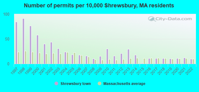
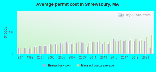
Single-family new house construction building permits:
- 2022: 31 buildings, average cost: $145,200
- 2021: 40 buildings, average cost: $292,600
- 2020: 35 buildings, average cost: $292,600
- 2019: 34 buildings, average cost: $292,600
- 2018: 35 buildings, average cost: $292,600
- 2017: 35 buildings, average cost: $292,600
- 2016: 36 buildings, average cost: $292,600
- 2015: 4 buildings, average cost: $343,300
- 2014: 57 buildings, average cost: $230,500
- 2013: 93 buildings, average cost: $226,200
- 2012: 66 buildings, average cost: $276,800
- 2011: 51 buildings, average cost: $272,200
- 2010: 96 buildings, average cost: $160,700
- 2009: 49 buildings, average cost: $258,100
- 2008: 34 buildings, average cost: $250,400
- 2007: 50 buildings, average cost: $235,100
- 2006: 57 buildings, average cost: $283,700
- 2005: 59 buildings, average cost: $242,300
- 2004: 76 buildings, average cost: $233,400
- 2003: 97 buildings, average cost: $222,600
- 2002: 139 buildings, average cost: $186,400
- 2001: 127 buildings, average cost: $181,300
- 2000: 184 buildings, average cost: $164,200
- 1999: 243 buildings, average cost: $122,900
- 1998: 290 buildings, average cost: $126,500
- 1997: 268 buildings, average cost: $129,100
| Here: | 2.9% |
| Massachusetts: | 3.5% |
- Health care (11.2%)
- Educational services (10.4%)
- Professional, scientific, technical services (9.5%)
- Computer & electronic products (7.2%)
- Finance & insurance (6.9%)
- Public administration (3.9%)
- Accommodation & food services (3.7%)
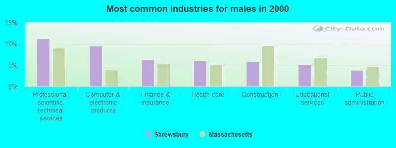
- Professional, scientific, technical services (11.3%)
- Computer & electronic products (9.5%)
- Finance & insurance (6.4%)
- Health care (6.1%)
- Construction (5.8%)
- Educational services (5.1%)
- Public administration (3.8%)
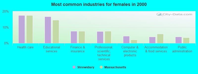
- Health care (17.5%)
- Educational services (16.8%)
- Finance & insurance (7.5%)
- Professional, scientific, technical services (7.4%)
- Computer & electronic products (4.5%)
- Accommodation & food services (4.1%)
- Public administration (4.0%)
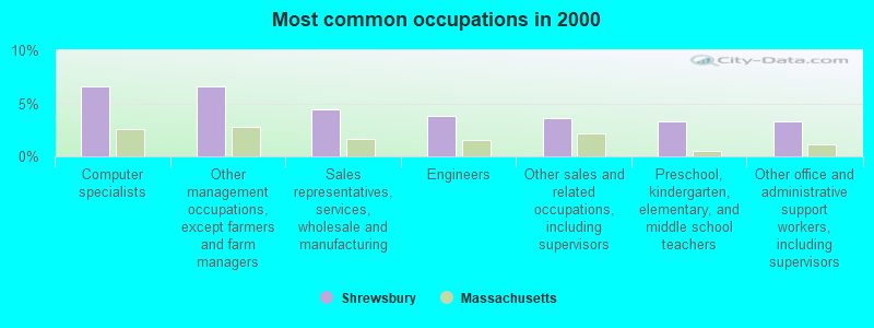
- Computer specialists (6.6%)
- Other management occupations, except farmers and farm managers (6.6%)
- Sales representatives, services, wholesale and manufacturing (4.4%)
- Engineers (3.8%)
- Other sales and related occupations, including supervisors (3.6%)
- Preschool, kindergarten, elementary, and middle school teachers (3.3%)
- Other office and administrative support workers, including supervisors (3.3%)
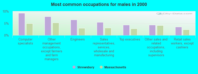
- Computer specialists (9.3%)
- Other management occupations, except farmers and farm managers (7.8%)
- Engineers (6.5%)
- Sales representatives, services, wholesale and manufacturing (5.5%)
- Top executives (4.4%)
- Other sales and related occupations, including supervisors (4.3%)
- Retail sales workers, except cashiers (3.5%)
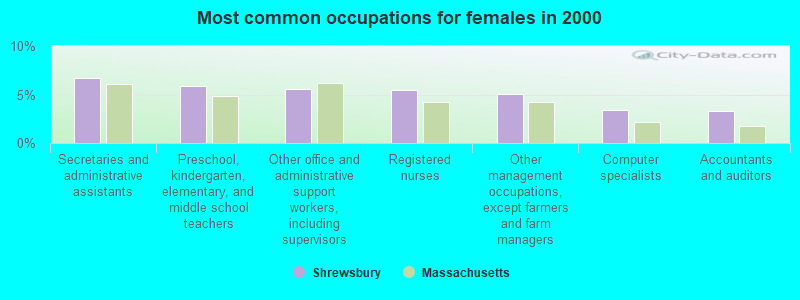
- Secretaries and administrative assistants (6.7%)
- Preschool, kindergarten, elementary, and middle school teachers (5.9%)
- Other office and administrative support workers, including supervisors (5.5%)
- Registered nurses (5.4%)
- Other management occupations, except farmers and farm managers (5.1%)
- Computer specialists (3.4%)
- Accountants and auditors (3.3%)
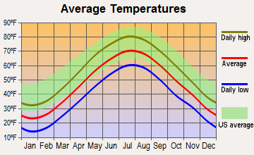
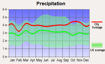
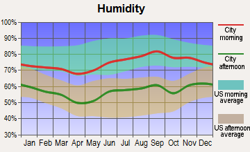
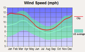
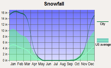
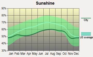
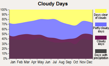
Average climate in Shrewsbury, Massachusetts
Based on data reported by over 4,000 weather stations
(lower is better)
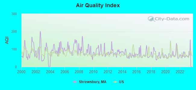
Air Quality Index (AQI) level in 2022 was 64.6. This is about average.
| City: | 64.6 |
| U.S.: | 72.6 |
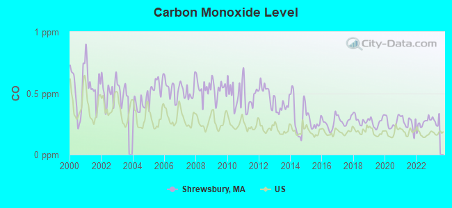
Carbon Monoxide (CO) [ppm] level in 2022 was 0.259. This is about average. Closest monitor was 3.9 miles away from the city center.
| City: | 0.259 |
| U.S.: | 0.251 |
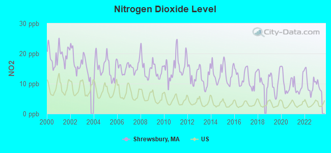
Nitrogen Dioxide (NO2) [ppb] level in 2022 was 10.1. This is significantly worse than average. Closest monitor was 2.0 miles away from the city center.
| City: | 10.1 |
| U.S.: | 5.1 |
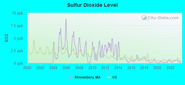
Sulfur Dioxide (SO2) [ppb] level in 2022 was 0.370. This is significantly better than average. Closest monitor was 2.0 miles away from the city center.
| City: | 0.370 |
| U.S.: | 1.515 |
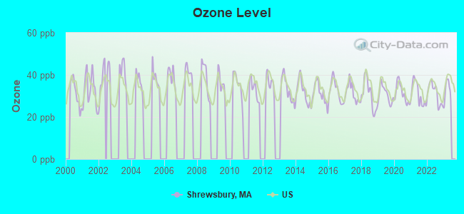
Ozone [ppb] level in 2022 was 31.2. This is about average. Closest monitor was 2.0 miles away from the city center.
| City: | 31.2 |
| U.S.: | 33.3 |
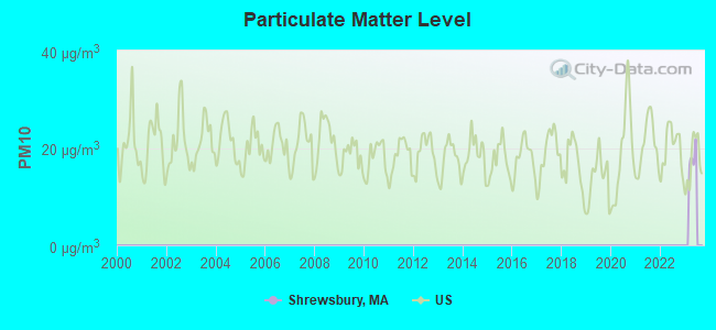
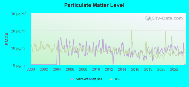
Particulate Matter (PM2.5) [µg/m3] level in 2022 was 8.71. This is about average. Closest monitor was 3.9 miles away from the city center.
| City: | 8.71 |
| U.S.: | 8.11 |
Tornado activity:
Shrewsbury-area historical tornado activity is slightly above Massachusetts state average. It is 22% smaller than the overall U.S. average.
On 6/9/1953, a category F4 (max. wind speeds 207-260 mph) tornado 10.5 miles away from the Shrewsbury town center killed 90 people and injured 1228 people and caused between $50,000,000 and $500,000,000 in damages.
On 6/9/1953, a category F3 (max. wind speeds 158-206 mph) tornado 8.4 miles away from the town center injured 17 people and caused between $500,000 and $5,000,000 in damages.
Earthquake activity:
Shrewsbury-area historical earthquake activity is significantly above Massachusetts state average. It is 72% smaller than the overall U.S. average.On 10/7/1983 at 10:18:46, a magnitude 5.3 (5.1 MB, 5.3 LG, 5.1 ML, Class: Moderate, Intensity: VI - VII) earthquake occurred 175.3 miles away from Shrewsbury center
On 4/20/2002 at 10:50:47, a magnitude 5.3 (5.3 ML, Depth: 3.0 mi) earthquake occurred 183.1 miles away from Shrewsbury center
On 4/20/2002 at 10:50:47, a magnitude 5.2 (5.2 MB, 4.2 MS, 5.2 MW, 5.0 MW) earthquake occurred 182.2 miles away from Shrewsbury center
On 1/19/1982 at 00:14:42, a magnitude 4.7 (4.5 MB, 4.7 MD, 4.5 LG, Class: Light, Intensity: IV - V) earthquake occurred 84.2 miles away from Shrewsbury center
On 10/16/2012 at 23:12:25, a magnitude 4.7 (4.7 ML, Depth: 10.0 mi) earthquake occurred 105.6 miles away from Shrewsbury center
On 8/22/1992 at 12:20:32, a magnitude 4.8 (4.8 MB, 3.8 MS, 4.7 LG, Depth: 6.2 mi) earthquake occurred 232.0 miles away from the city center
Magnitude types: regional Lg-wave magnitude (LG), body-wave magnitude (MB), duration magnitude (MD), local magnitude (ML), surface-wave magnitude (MS), moment magnitude (MW)
Natural disasters:
The number of natural disasters in Worcester County (27) is a lot greater than the US average (15).Major Disasters (Presidential) Declared: 15
Emergencies Declared: 12
Causes of natural disasters: Floods: 9, Storms: 8, Hurricanes: 6, Snowstorms: 5, Winter Storms: 4, Blizzards: 2, Snows: 2, Fire: 1, Heavy Rain: 1, Snowfall: 1, Tornado: 1, Wind: 1 (Note: some incidents may be assigned to more than one category).
Hospitals and medical centers in Shrewsbury:
- IRVING A GALVIN REGIONAL CENTER (214 LAKE STREET)
- SHREWSBURY NURSING AND REHABILITATION CENTER (40 JULIO DRIVE)
- SHREWSBURY NURSING HOME (66 SOUTH ST)
- UNIVERSITY DIALYSIS CENTER (BMA OF SHREWSBURY) (239-243 BOSTON TURNPIKE ROAD)
- AMERICARE AT HOME INC (415 BOSTON TURNPIKE SUITE 100)
- PEDIATRIA HEALTHCARE FOR KIDS (196 BOSTON TURNPIKE ROAD)
Heliports located in Shrewsbury:
Amtrak stations near Shrewsbury:
- 4 miles: WORCESTER (WORCHESTER, 45 SHREWSBURY ST.) . Services: ticket office, fully wheelchair accessible, enclosed waiting area, public restrooms, public payphones, vending machines, free short-term parking, free long-term parking, call for taxi service, public transit connection.
- 16 miles: FRAMINGHAM (443 WAVERLY ST.) . Services: public payphones, snack bar, paid short-term parking, taxi stand, public transit connection.
Colleges/universities with over 2000 students nearest to Shrewsbury:
- Quinsigamond Community College (about 5 miles; Worcester, MA; Full-time enrollment: 5,877)
- Worcester Polytechnic Institute (about 5 miles; Worcester, MA; FT enrollment: 3,930)
- Assumption College (about 6 miles; Worcester, MA; FT enrollment: 2,580)
- College of the Holy Cross (about 6 miles; Worcester, MA; FT enrollment: 3,125)
- Clark University (about 6 miles; Worcester, MA; FT enrollment: 3,687)
- Worcester State University (about 7 miles; Worcester, MA; FT enrollment: 5,426)
- Framingham State University (about 15 miles; Framingham, MA; FT enrollment: 5,743)
Public high school in Shrewsbury:
- SHREWSBURY SR HIGH (Students: 1,584, Location: 64 HOLDEN STREET, Grades: 9-12)
Private high school in Shrewsbury:
Public elementary/middle schools in Shrewsbury:
- SHERWOOD MIDDLE SCHOOL (Students: 950, Location: 28 SHERWOOD AVENUE, Grades: 5-6)
- OAK MIDDLE SCHOOL (Students: 950, Location: 45 OAK STREET, Grades: 7-8)
- FLORAL STREET SCHOOL (Students: 745, Location: 57 FLORAL STREET, Grades: 1-4)
- BEAL SCHOOL (Students: 412, Location: 1 MAPLE AVENUE, Grades: KG-1)
- SPRING STREET (Students: 399, Location: 123 SPRING STREET, Grades: KG-4)
- WALTER J PATON (Students: 356, Location: 58 GRAFTON STREET, Grades: KG-4)
- CALVIN COOLIDGE (Students: 331, Location: 1 FLORENCE STREET, Grades: KG-4)
Private elementary/middle schools in Shrewsbury:
- ST MARY ELEMENTARY SCHOOL (Students: 277, Location: 16 SUMMER ST, Grades: PK-8)
- LILLIPUT EARLY CHILDHOOD CENTER (Students: 229, Location: 18 GRAFTON ST, Grades: PK-1)
- AL-HAMRA ACADEMY (Students: 165, Location: 435 SOUTH ST, Grades: PK-8)
- SHREWSBURY MONTESSORI SCHOOL (Students: 164, Location: 55 OAK ST, Grades: PK-6)
- KINDERCARE LEARNING CENTER (Students: 44, Location: 177 MAIN ST, Grades: PK-1)
Library in Shrewsbury:
User-submitted facts and corrections:
- Under Hospitals - UMass Memorial Hospital, Worcester - should be included. I don't believe Worcester County Hospital is an operational hospital any more.
- Shrewsbury has built a brand new high school. It is no longer on Oak Street.
Points of interest:
Notable locations in Shrewsbury: Hills Farm Industrial Park (A), Camp Wunnegon (B), Camp Wunnegan (C), Shrewsbury Fire Department Station 2 Lake Station (D), Shrewsbury Fire Department (E), Shrewsbury Fire Department Station Headquarters (F), Shrewsbury High School Library Media Center (G), Worcester Foundation for Biomedical Research (H), Shrewsbury Public Library (I), Saint Marys Pastoral Center (J), George F Fuller Research Library (K), General Artemas Ward House (L), Masonic Nursing Home (M), Retreat House (N). Display/hide their locations on the map
Shopping Centers: Shrewsbury Crossing Shopping Center (1), White City East Shopping Center (2), Fairlawn Shopping Center (3), White City and White City East Shopping Center (4). Display/hide their locations on the map
Churches in Shrewsbury include: Trinity Episcopal Church (A), Saint Marys Assyrian Orthodox Church (B), Mount Olivet Lutheran Church (C), Grace Baptist Church (D), First Congregational Church (E). Display/hide their locations on the map
Cemeteries: Hillcrest Cemetery (1), Mountain View Cemetery (2), Hillcrest Cemetery (3), Mountain View Cemetery (4). Display/hide their locations on the map
Lakes, reservoirs, and swamps: Eaton Pond (A), Jordan Pond (B), Mill Pond (C), West Brook Reservoir (D), Rawson Mill Brook Reservoir (E), Newton Pond (F), Mud Pond (G), Northborough Reservoir (H). Display/hide their locations on the map
Streams, rivers, and creeks: Meadow Brook (A), Sewall Brook (B), West Brook (C), Poor Farm Brook (D). Display/hide their locations on the map
Parks in Shrewsbury include: Shrewsbury Historic District (1), Saint Johns Athletic Field (2), Mill Pond Park (3), Jordan Pond Recreation Area (4), Dean Park (5). Display/hide their locations on the map
Tourist attractions: Balloonary Magic World (Amusement & Theme Parks; 257 Boston Turnpike) (1), Town & Country Bowl (Amusement & Theme Parks; 405 Boston Turnpike) (2), Jim's Professional Shop (Amusement & Theme Parks; 405 Boston Turnpike) (3), Skater Paradise Inc (Arcades & Amusements; 590 Lake St) (4). Display/hide their approximate locations on the map
Birthplace of: Artemas Ward - Continental Army general, Jesse Lauriston Livermore - Financier, Mike Birbiglia - Comedy musician, Ebenezer Brigham - Wisconsin pioneer, Gregory Mcdonald - Novelist, Marc Busenburg - NHL player (Tampa Bay Lightning, born: Dec 2, 1977), Brian Darcy - College basketball player (Harvard Crimson), Gardner Howe - Politician, Jonah Howe - Politician, Nahum Parker - Politician.
Drinking water stations with addresses in Shrewsbury and their reported violations in the past:
SHREWSBURY WATER DEPARTMENT (Population served: 35,608, Groundwater):Past health violations:Past monitoring violations:
- MCL, Monthly (TCR) - In JUN-2013, Contaminant: Coliform. Follow-up actions: St AO (w/o penalty) issued (AUG-07-2013), St Compliance achieved (AUG-07-2013)
- One minor monitoring violation
| This town: | 2.6 people |
| Massachusetts: | 2.5 people |
| This town: | 70.7% |
| Whole state: | 63.0% |
| This town: | 4.2% |
| Whole state: | 7.0% |
Likely homosexual households (counted as self-reported same-sex unmarried-partner households)
- Lesbian couples: 0.4% of all households
- Gay men: 0.3% of all households
| This town: | 4.8% |
| Whole state: | 9.3% |
| This town: | 1.8% |
| Whole state: | 4.4% |
People in group quarters in Shrewsbury in 2010:
- 245 people in workers' group living quarters and job corps centers
- 87 people in nursing facilities/skilled-nursing facilities
- 58 people in residential treatment centers for adults
- 14 people in group homes intended for adults
People in group quarters in Shrewsbury in 2000:
- 106 people in nursing homes
- 59 people in homes for the mentally retarded
- 12 people in religious group quarters
Banks with most branches in Shrewsbury (2011 data):
- RBS Citizens, National Association: Shrewsbury Branch at 50 Boston Turnpike, branch established on 2006/01/09; Shrewsbury Stop & Shop Branch at 539 Boston Tpk, branch established on 2003/08/25. Info updated 2007/09/19: Bank assets: $106,940.6 mil, Deposits: $75,690.2 mil, headquarters in Providence, RI, positive income, 1135 total offices, Holding Company: Uk Financial Investments Limited
- Sovereign Bank, National Association: Shrewsbury Branch at 47 Maple Avenue, branch established on 1968/12/20; Shrewsbury White City Branch at 110 Boston Turnpike, Route 9, branch established on 1934/01/01. Info updated 2012/01/31: Bank assets: $78,146.9 mil, Deposits: $48,042.9 mil, headquarters in Wilmington, DE, positive income, Commercial Lending Specialization, 718 total offices, Holding Company: Banco Santander, S.A.
- TD Bank, National Association: Shrewsbury Branch at 200 Boston Turnpike, branch established on 1957/12/16. Info updated 2010/10/04: Bank assets: $188,912.6 mil, Deposits: $153,149.8 mil, headquarters in Wilmington, DE, positive income, 1314 total offices, Holding Company: Toronto-Dominion Bank, The
- Bank of America, National Association: Shrewsbury Branch at 188 Boston Turnpike, branch established on 1988/10/31. Info updated 2009/11/18: Bank assets: $1,451,969.3 mil, Deposits: $1,077,176.8 mil, headquarters in Charlotte, NC, positive income, 5782 total offices, Holding Company: Bank Of America Corporation
- Commerce Bank & Trust Company: Shrewsbury Branch at 226 Boston Turnpike, branch established on 1968/01/02. Info updated 2006/10/06: Bank assets: $1,410.8 mil, Deposits: $1,187.6 mil, headquarters in Worcester, MA, positive income, Commercial Lending Specialization, 14 total offices, Holding Company: Commerce Bancshares Corp.
- Avidia Bank: Shrewsbury Branch at 23 Maple Avenue, branch established on 1995/12/07. Info updated 2010/01/04: Bank assets: $1,026.2 mil, Deposits: $801.2 mil, headquarters in Hudson, MA, positive income, Commercial Lending Specialization, 10 total offices, Holding Company: Assabet Valley Bancorp
- People's United Bank: Shrewsbury Branch at 555 Main Street, branch established on 1999/06/01. Info updated 2012/02/16: Bank assets: $27,319.3 mil, Deposits: $20,835.4 mil, headquarters in Bridgeport, CT, positive income, Commercial Lending Specialization, 374 total offices
- United Bank: Main Street Branch at 564 Main Street, branch established on 2003/01/27. Info updated 2012/01/20: Bank assets: $1,617.9 mil, Deposits: $1,235.2 mil, headquarters in West Springfield, MA, positive income, Commercial Lending Specialization, 25 total offices
- Webster Five Cents Savings Bank: Shrewsbury Branch at 261 Grafton Street, branch established on 2006/02/14. Info updated 2009/05/20: Bank assets: $558.9 mil, Deposits: $465.4 mil, headquarters in Webster, MA, positive income, Commercial Lending Specialization, 8 total offices, Holding Company: Webfive Mhc
For population 15 years and over in Shrewsbury:
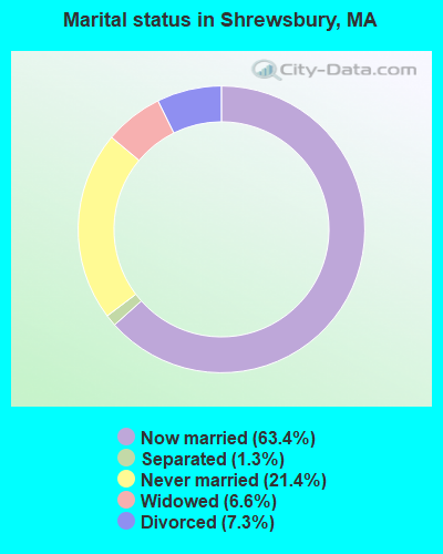
- Never married: 21.4%
- Now married: 63.4%
- Separated: 1.3%
- Widowed: 6.6%
- Divorced: 7.3%
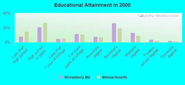
For population 25 years and over in Shrewsbury:
- High school or higher: 91.8%
- Bachelor's degree or higher: 46.1%
- Graduate or professional degree: 19.6%
- Unemployed: 2.9%
- Mean travel time to work (commute): 26.8 minutes
| Here: | 11.2 |
| Massachusetts average: | 13.1 |


Graphs represent county-level data. Detailed 2008 Election Results
Religion statistics for Shrewsbury, MA (based on Worcester County data)


| Religion | Adherents | Congregations |
|---|---|---|
| Catholic | 306,925 | 118 |
| Mainline Protestant | 43,326 | 171 |
| Evangelical Protestant | 37,511 | 203 |
| Other | 18,931 | 69 |
| Orthodox | 7,935 | 15 |
| Black Protestant | 497 | 6 |
| None | 383,427 | - |
Food Environment Statistics:
| Worcester County: | 1.73 / 10,000 pop. |
| Massachusetts: | 1.98 / 10,000 pop. |
| Worcester County: | 0.05 / 10,000 pop. |
| Massachusetts: | 0.05 / 10,000 pop. |
| Worcester County: | 1.79 / 10,000 pop. |
| Massachusetts: | 2.22 / 10,000 pop. |
| Worcester County: | 2.22 / 10,000 pop. |
| Massachusetts: | 1.77 / 10,000 pop. |
| This county: | 7.27 / 10,000 pop. |
| Massachusetts: | 8.76 / 10,000 pop. |
| Worcester County: | 8.0% |
| Massachusetts: | 8.1% |
| Here: | 24.0% |
| Massachusetts: | 22.5% |
| Worcester County: | 16.6% |
| Massachusetts: | 16.5% |
4.71% of this county's 2021 resident taxpayers lived in other counties in 2020 ($76,229 average adjusted gross income)
| Here: | 4.71% |
| Massachusetts average: | 6.35% |
0.02% of residents moved from foreign countries ($100 average AGI)
Worcester County: 0.02% Massachusetts average: 0.01%
Top counties from which taxpayers relocated into this county between 2020 and 2021:
| from Middlesex County, MA | |
| from Norfolk County, MA | |
| from Suffolk County, MA |
4.84% of this county's 2020 resident taxpayers moved to other counties in 2021 ($87,252 average adjusted gross income)
| Here: | 4.84% |
| Massachusetts average: | 7.18% |
0.03% of residents moved to foreign countries ($199 average AGI)
Worcester County: 0.03% Massachusetts average: 0.02%
Top counties to which taxpayers relocated from this county between 2020 and 2021:
| to Middlesex County, MA | |
| to Norfolk County, MA | |
| to Suffolk County, MA |
| Businesses in Shrewsbury, MA | ||||
| Name | Count | Name | Count | |
|---|---|---|---|---|
| 7-Eleven | 1 | KFC | 1 | |
| AMF Bowling | 1 | Mazda | 1 | |
| AT&T | 1 | McDonald's | 1 | |
| Audi | 1 | Panera Bread | 1 | |
| AutoZone | 1 | Penske | 1 | |
| BMW | 1 | Pier 1 Imports | 1 | |
| Bed Bath & Beyond | 1 | Rite Aid | 1 | |
| Burger King | 1 | Sears | 1 | |
| Burlington Coat Factory | 1 | Shaw's | 1 | |
| CVS | 1 | Sprint Nextel | 1 | |
| Casual Male XL | 1 | Staples | 1 | |
| Chipotle | 1 | Stop & Shop | 1 | |
| Days Inn | 1 | Subaru | 1 | |
| Domino's Pizza | 1 | Subway | 1 | |
| DressBarn | 1 | T-Mobile | 1 | |
| Dressbarn | 1 | Taco Bell | 1 | |
| Dunkin Donuts | 5 | Trader Joe's | 1 | |
| FedEx | 8 | UPS | 8 | |
| Firestone Complete Auto Care | 1 | Vans | 1 | |
| H&R Block | 1 | Verizon Wireless | 2 | |
| Home Depot | 1 | Walgreens | 1 | |
| IHOP | 1 | World Gym | 1 | |
Strongest AM radio stations in Shrewsbury:
- WCRN (830 AM; 50 kW; WORCESTER, MA; Owner: CARTER BROADCASTING CORPORATION)
- WTAG (580 AM; 5 kW; WORCESTER, MA; Owner: CAPSTAR TX LIMITED PARTNERSHIP)
- WKOX (1200 AM; 50 kW; FRAMINGHAM, MA; Owner: CAPSTAR TX LIMITED PARTNERSHIP)
- WBIX (1060 AM; 40 kW; NATICK, MA; Owner: LANGER BROADCASTING CORPORATION)
- WAMG (890 AM; 25 kW; DEDHAM, MA; Owner: MEGA COMMUNICATIONS OF DEDHAM LICENSEE, LLC)
- WEEI (850 AM; 50 kW; BOSTON, MA; Owner: ENTERCOM BOSTON LICENSE, LLC)
- WVNE (760 AM; daytime; 25 kW; LEICESTER, MA; Owner: BLOUNT MASSCOM, INC.)
- WVEI (1440 AM; 5 kW; WORCESTER, MA; Owner: ENTERCOM BOSTON LICENSE, LLC)
- WORC (1310 AM; 5 kW; WORCESTER, MA; Owner: CHOWDER BROADCAST GROUP LLC)
- WALE (990 AM; 50 kW; GREENVILLE, RI; Owner: NORTH AMERICAN BROADCASTING CO., INC.)
- WRKO (680 AM; 50 kW; BOSTON, MA; Owner: ENTERCOM BOSTON LICENSE, LLC)
- WAZN (1470 AM; 7 kW; MARLBOROUGH, MA; Owner: MULTICULTURAL RADIO BROADCASTING, INC.)
- WWZN (1510 AM; 50 kW; BOSTON, MA; Owner: ROSE CITY RADIO CORPORATION)
Strongest FM radio stations in Shrewsbury:
- WICN (90.5 FM; WORCESTER, MA; Owner: WICN PUBLIC RADIO, INC)
- WAAF (107.3 FM; WORCESTER, MA; Owner: ENTERCOM BOSTON LICENSE, LLC)
- WSRS (96.1 FM; WORCESTER, MA; Owner: CAPSTAR TX LIMITED PARTNERSHIP)
- WCUW (91.3 FM; WORCESTER, MA; Owner: WUW, INC.)
- WXLO (104.5 FM; FITCHBURG, MA; Owner: CITADEL BROADCASTING COMPANY)
- WBMX (98.5 FM; BOSTON, MA; Owner: INFINITY RADIO OPERATIONS INC.)
- WJMN (94.5 FM; BOSTON, MA; Owner: AMFM RADIO LICENSES, L.L.C.)
- WCRB (102.5 FM; WALTHAM, MA; Owner: CHARLES RIVER BROADCASTING WCRB LICE)
- WTKK (96.9 FM; BOSTON, MA; Owner: GREATER BOSTON RADIO, INC.)
- WROR-FM (105.7 FM; FRAMINGHAM, MA; Owner: GREATER BOSTON RADIO, INC.)
- WBOS (92.9 FM; BROOKLINE, MA; Owner: GREATER BOSTON RADIO, INC.)
- WGBH (89.7 FM; BOSTON, MA; Owner: WGBH EDUCATIONAL FOUNDATION)
- WBUR-FM (90.9 FM; BOSTON, MA; Owner: TRUSTEES OF BOSTON UNIVERSITY)
- WODS (103.3 FM; BOSTON, MA; Owner: INFINITY BROADCASTING OPERATIONS, INC.)
- WXKS-FM (107.9 FM; MEDFORD, MA; Owner: AMFM RADIO LICENSES, L.L.C.)
- WMJX (106.7 FM; BOSTON, MA; Owner: GREATER BOSTON RADIO, INC.)
- WBPR (91.9 FM; WORCESTER, MA; Owner: UNIVERSITY OF MASSACHUSETTS)
- WFEX (92.1 FM; PETERBOROUGH, NH; Owner: FNX BROADCASTING OF NEW HAMPSHIRE LLC)
- WYCM (90.1 FM; CHARLTON, MA; Owner: BAY PATH VOCATIONAL HIGH SCHOOL)
- WFCR (88.5 FM; AMHERST, MA; Owner: UNIVERSITY OF MASSACHUSETTS)
TV broadcast stations around Shrewsbury:
- WUNI (Channel 27; WORCESTER, MA; Owner: ENTRAVISION HOLDINGS, LLC)
- WUTF (Channel 66; MARLBOROUGH, MA; Owner: TELEFUTURA BOSTON LLC)
- WCVB-TV (Channel 5; BOSTON, MA; Owner: WCVB HEARST-ARGYLE TV, INC.)
- WGBH-TV (Channel 2; BOSTON, MA; Owner: WGBH EDUCATIONAL FOUNDATION)
- WMFP (Channel 62; LAWRENCE, MA; Owner: WSAH LICENSE, INC.)
- WHDH-TV (Channel 7; BOSTON, MA; Owner: WHDH-TV)
- WBZ-TV (Channel 4; BOSTON, MA; Owner: VIACOM INC.)
- WGBX-TV (Channel 44; BOSTON, MA; Owner: WGBH EDUCATIONAL FOUNDATION)
- WSBK-TV (Channel 38; BOSTON, MA; Owner: VIACOM INC.)
- WLVI-TV (Channel 56; CAMBRIDGE, MA; Owner: WLVI, INC.)
- WCRN-LP (Channel 34; LEICESTER, MA; Owner: CARTER BROADCASTING CORPORATION)
- WFXT (Channel 25; BOSTON, MA; Owner: FOX TELEVISION STATIONS INC.)
- WYDN (Channel 48; WORCESTER, MA; Owner: EDUCATIONAL PUBLIC TV CORPORATION)
- W40BO (Channel 40; BOSTON, MA; Owner: PAXSON COMMUNICATIONS LPTV, INC.)
- WBPX (Channel 68; BOSTON, MA; Owner: PAXSON BOSTON-68 LICENSE, INC.)
- WPXQ (Channel 69; BLOCK ISLAND, RI; Owner: OCEAN STATE TELEVISION, L.L.C.)
- WNAC-TV (Channel 64; PROVIDENCE, RI; Owner: WNAC, LLC)
- WPRI-TV (Channel 12; PROVIDENCE, RI; Owner: TVL BROADCASTING OF RHODE ISLAND, LLC)
- WTMU-LP (Channel 32; BOSTON, MA; Owner: ZGS BOSTON, INC.)
- WWDP (Channel 46; NORWELL, MA; Owner: NORWELL TELEVISION, LLC)
- WCEA-LP (Channel 58; BOSTON, MA; Owner: CHANNEL 19 TV CORPORATION)
- WLNE-TV (Channel 6; NEW BEDFORD, MA; Owner: FREEDOM BROADCASTING OF SOUTHERN NEW ENGLAND, INC.)
- WJAR (Channel 10; PROVIDENCE, RI; Owner: OUTLET BROADCASTING, INC.)
- WSBE-TV (Channel 36; PROVIDENCE, RI; Owner: RHODE ISLAND PUBLIC TELECOM. AUTHORITY)
- National Bridge Inventory (NBI) Statistics
- 19Number of bridges
- 469ft / 143mTotal length
- $76,353,000Total costs
- 545,810Total average daily traffic
- 42,290Total average daily truck traffic
- New bridges - historical statistics
- 21930-1939
- 121960-1969
- 11990-1999
- 22000-2009
- 22010-2019
FCC Registered Broadcast Land Mobile Towers: 14 (See the full list of FCC Registered Broadcast Land Mobile Towers in Shrewsbury, MA)
FCC Registered Microwave Towers: 11 (See the full list of FCC Registered Microwave Towers in this town)
FCC Registered Amateur Radio Licenses: 130 (See the full list of FCC Registered Amateur Radio Licenses in Shrewsbury)
FAA Registered Aircraft: 10 (See the full list of FAA Registered Aircraft in Shrewsbury)
2002 - 2018 National Fire Incident Reporting System (NFIRS) incidents
- Fire incident types reported to NFIRS in Shrewsbury, MA
- 1,14455.5%Structure Fires
- 60729.5%Outside Fires
- 27113.1%Mobile Property/Vehicle Fires
- 391.9%Other
 According to the data from the years 2002 - 2018 the average number of fire incidents per year is 121. The highest number of fires - 160 took place in 2012, and the least - 82 in 2014. The data has a declining trend.
 When looking into fire subcategories, the most reports belonged to: Structure Fires (55.5%), and Outside Fires (29.5%).
| Most common first names in Shrewsbury, MA among deceased individuals | ||
| Name | Count | Lived (average) |
|---|---|---|
| Mary | 246 | 83.4 years |
| John | 242 | 75.3 years |
| Joseph | 174 | 76.7 years |
| Helen | 127 | 81.8 years |
| William | 123 | 75.6 years |
| George | 106 | 78.1 years |
| James | 96 | 78.2 years |
| Robert | 91 | 68.5 years |
| Anna | 80 | 84.9 years |
| Edward | 78 | 76.1 years |
| Most common last names in Shrewsbury, MA among deceased individuals | ||
| Last name | Count | Lived (average) |
|---|---|---|
| Johnson | 61 | 77.5 years |
| Anderson | 45 | 80.1 years |
| Sullivan | 30 | 79.6 years |
| Brown | 30 | 75.4 years |
| Carlson | 28 | 75.8 years |
| Murphy | 27 | 76.2 years |
| Adams | 27 | 84.4 years |
| Smith | 26 | 76.7 years |
| Obrien | 20 | 74.2 years |
| Martin | 20 | 79.7 years |
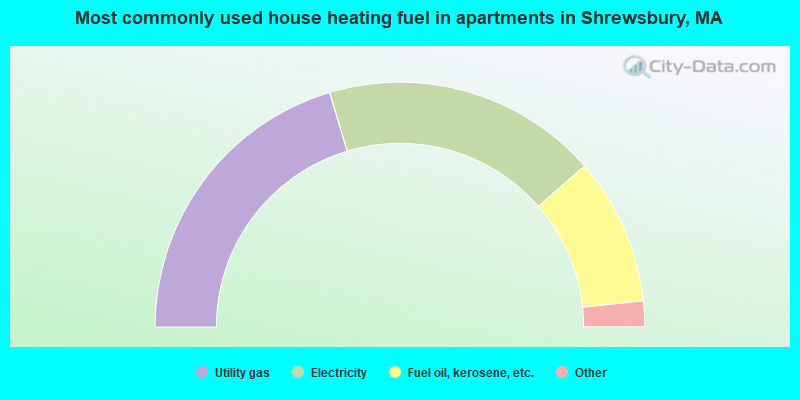
- 46.7%Utility gas
- 42.3%Fuel oil, kerosene, etc.
- 9.2%Electricity
- 0.8%Bottled, tank, or LP gas
- 0.4%Wood
- 0.3%Other fuel
- 0.2%Coal or coke
- 40.7%Utility gas
- 36.4%Electricity
- 19.4%Fuel oil, kerosene, etc.
- 2.4%Bottled, tank, or LP gas
- 0.6%No fuel used
- 0.2%Other fuel
- 0.2%Solar energy
Shrewsbury compared to Massachusetts state average:
- Unemployed percentage significantly below state average.
- Black race population percentage significantly below state average.
- Hispanic race population percentage significantly below state average.
- Foreign-born population percentage below state average.
- Length of stay since moving in significantly above state average.
- Number of rooms per house significantly below state average.
- House age significantly below state average.
Shrewsbury on our top lists:
- #29 on the list of "Top 101 cities with largest percentage of males in occupations: computer specialists (population 5,000+)"
- #41 on the list of "Top 101 cities with largest percentage of males in industries: computer and electronic products (population 5,000+)"
- #45 on the list of "Top 101 cities with largest percentage of females in industries: alcoholic beverages merchant wholesalers (population 5,000+)"
- #50 on the list of "Top 101 cities with largest percentage of females in occupations: accountants and auditors (population 5,000+)"
- #50 on the list of "Top 101 cities with largest percentage of females in industries: radio, tv, and computer stores (population 5,000+)"
- #51 on the list of "Top 101 cities with largest percentage of females in occupations: judges, magistrates, and other judicial workers (population 5,000+)"
- #54 on the list of "Top 101 cities with largest percentage of females in occupations: advertising, marketing, promotions, public relations, and sales managers (population 5,000+)"
- #62 on the list of "Top 101 cities with largest percentage of males in occupations: engineers (population 5,000+)"
- #63 on the list of "Top 101 cities with largest percentage of males in industries: pharmacies and drug stores (population 5,000+)"
- #64 on the list of "Top 101 cities with largest percentage of females in occupations: physicians and surgeons (population 5,000+)"
- #70 on the list of "Top 101 cities with largest percentage of females in industries: computer and electronic products (population 5,000+)"
- #87 on the list of "Top 101 cities with largest percentage of males in industries: radio, tv, and computer stores (population 5,000+)"
- #88 on the list of "Top 101 cities with largest percentage of males in industries: professional and commercial equipment and supplies merchant wholesalers (population 5,000+)"
- #101 on the list of "Top 101 cities with largest percentage of males in industries: other direct selling establishments (population 5,000+)"
- #4 on the list of "Top 101 counties with the highest carbon monoxide air pollution readings in 2012 (ppm)"
- #5 on the list of "Top 101 counties with the most Catholic congregations"
- #12 on the list of "Top 101 counties with the highest surface withdrawal of fresh water for public supply"
- #16 on the list of "Top 101 counties with the highest total withdrawal of fresh water for public supply"
- #23 on the list of "Top 101 counties with the highest Sulfur Oxides Annual air pollution readings in 2012 (µg/m3)"
State forum archive:

|
|
Total of 2360 patent applications in 2008-2024.