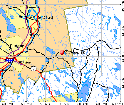
Clifton, Maine
Submit your own pictures of this town and show them to the world
- OSM Map
- General Map
- Google Map
- MSN Map
Population change since 2000: +24.0%
| Males: 481 | |
| Females: 440 |
| Median resident age: | 41.1 years |
| Maine median age: | 43.0 years |
Zip codes: 04428.
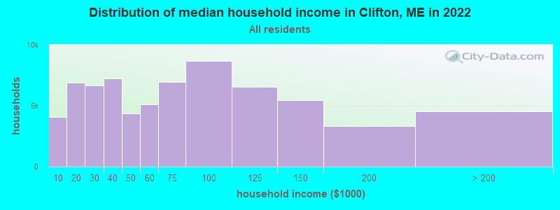
| Clifton: | $64,807 |
| ME: | $69,543 |
Estimated per capita income in 2022: $32,928 (it was $16,380 in 2000)
Clifton town income, earnings, and wages data
Estimated median house or condo value in 2022: $209,727 (it was $80,600 in 2000)
| Clifton: | $209,727 |
| ME: | $290,600 |
Mean prices in 2022: all housing units: $235,563; detached houses: $252,705; townhouses or other attached units: $267,749; in 2-unit structures: $255,332; in 3-to-4-unit structures: $815,300; in 5-or-more-unit structures: $185,873; mobile homes: $93,017; occupied boats, rvs, vans, etc.: $21,333
Detailed information about poverty and poor residents in Clifton, ME
Compare current foreclosures near Clifton, ME:
| Photo | Address | Area | Beds / Baths | Price | Details |
|---|---|---|---|---|---|

|
#1
Warren St
Bangor, ME 04401
|
2,842 sq. feet
|
3 baths 5 beds |
show details | |

|
#2
Maxwell Ln
Bangor, ME 04401
|
1,750 sq. feet
|
2 baths 3 beds |
show details | |

|
#3
Rd
Brewer, ME 04412
|
2,428 sq. feet
|
1 baths 4 beds |
show details | |

|
#4
Allen St
Bangor, ME 04401
|
1,200 sq. feet
|
1 baths 3 beds |
show details | |

|
#5
Lancaster Ave
Bangor, ME 04401
|
324 sq. feet
|
1 baths 1 beds |
show details | |

|
#6
Grove St
Bangor, ME 04401
|
910 sq. feet
|
1 baths 3 beds |
show details | |

|
#7
Call Rd # D
Milford, ME 04461
|
- sq. feet
|
- baths - beds |
show details | |

|
#8
Pine St # B
Bangor, ME 04401
|
- sq. feet
|
- baths - beds |
show details | |

|
#9
Baker Blvd Ste 205
Brewer, ME 04412
|
- sq. feet
|
- baths - beds |
show details | |

|
#10
Summer St
Old Town, ME 04468
|
- sq. feet
|
- baths - beds |
show details |
| Photo | Address | Area | Beds / Baths | Price | Details |
|---|---|---|---|---|---|

|
#11
Harris Rd Apt 31
Orono, ME 04473
|
- sq. feet
|
- baths - beds |
show details | |

|
#12
Cedar St Apt 4
Bangor, ME 04401
|
- sq. feet
|
- baths - beds |
show details | |

|
#13
Bennoch Rd
Old Town, ME 04468
|
- sq. feet
|
- baths - beds |
show details | |

|
#14
Pioneer Way
Aurora, ME 04408
|
- sq. feet
|
- baths - beds |
show details | |

|
#15
Pleasant Hill Ln
Orrington, ME 04474
|
- sq. feet
|
- baths - beds |
show details | |

|
#16
Aa Landing Rd
Bangor, ME 04401
|
- sq. feet
|
- baths - beds |
show details | |

|
#17
W Old Town Rd
Old Town, ME 04468
|
- sq. feet
|
- baths - beds |
show details | |

|
#18
Gott Brook Hts
Orland, ME 04472
|
- sq. feet
|
- baths - beds |
show details | |

|
#19
Merrill Rd
Eddington, ME 04428
|
- sq. feet
|
- baths - beds |
show details | |

|
#20
Mariaville Rd
Ellsworth, ME 04605
|
- sq. feet
|
- baths - beds |
show details |
| Photo | Address | Area | Beds / Baths | Price | Details |
|---|---|---|---|---|---|

|
#21
Kenduskeag Ave # 24
Bangor, ME 04401
|
- sq. feet
|
- baths - beds |
show details | |

|
#22
S Road
Brewer, ME 04412
|
- sq. feet
|
- baths - beds |
show details | |

|
#23
South Rd
Brewer, ME 04412
|
- sq. feet
|
- baths - beds |
show details | |

|
#24
Greenfield Rd
Greenbush, ME 04418
|
- sq. feet
|
- baths - beds |
show details | |

|
Check over 1 million property listings on Foreclosure.com!
|
browse all offers | |||

- 86694.0%White alone
- 192.1%Two or more races
- 141.5%American Indian alone
- 101.1%Black alone
- 91.0%Hispanic
- 30.3%Asian alone
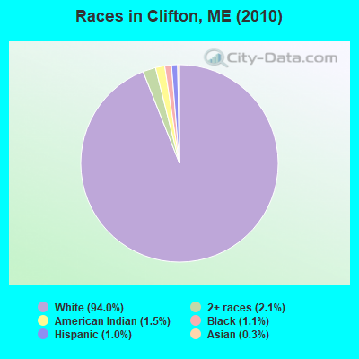
Races in Clifton detailed stats: ancestries, foreign born residents, place of birth
According to our research of Maine and other state lists, there were 3 registered sex offenders living in Clifton, Maine as of April 26, 2024.
The ratio of all residents to sex offenders in Clifton is 307 to 1.
 Recent articles from our blog. Our writers, many of them Ph.D. graduates or candidates, create easy-to-read articles on a wide variety of topics.


 | Looking to move outside Bangor with kids (6 replies) |
| artist moving to Brewer/Bangor area. (16 replies) |
| Woodsy Areas not too far from Bangor/Orono area (3 replies) |
| Great Bangor suburb to live for families (19 replies) |
| Is there life east of Bangor? (115 replies) |
| Bangor Eastport directions clarification (30 replies) |
Latest news from Clifton, ME collected exclusively by city-data.com from local newspapers, TV, and radio stations
Ancestries: English (18.7%), United States (17.5%), Irish (13.3%), French (12.0%), German (7.5%), French Canadian (7.0%).
Current Local Time: EST time zone
Incorporated on 08/08/1848
Elevation: 307 feet
Land area: 34.4 square miles.
Population density: 27 people per square mile (very low).
4 residents are foreign born
| This town: | 0.5% |
| Maine: | 2.9% |
| Clifton town: | 1.2% ($959) |
| Maine: | 1.5% ($1,417) |
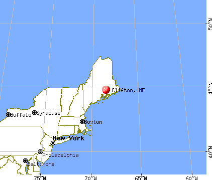
Nearest city with pop. 50,000+: Portland, ME  (116.9 miles , pop. 64,249).
Nearest city with pop. 200,000+: Boston, MA (214.5 miles , pop. 589,141).
Nearest city with pop. 1,000,000+: Bronx, NY (385.2 miles , pop. 1,332,650).
Nearest cities:
), ), ), ), ), Latitude: 44.81 N, Longitude: 68.53 W
Area code commonly used in this area: 207

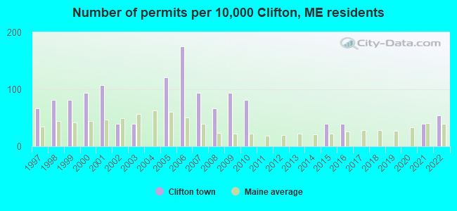
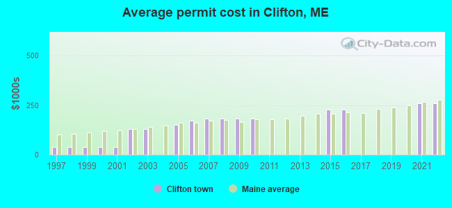
Single-family new house construction building permits:
- 2022: 4 buildings, average cost: $259,200
- 2021: 3 buildings, average cost: $259,200
- 2016: 3 buildings, average cost: $226,800
- 2015: 3 buildings, average cost: $226,800
- 2010: 6 buildings, average cost: $181,200
- 2009: 7 buildings, average cost: $181,200
- 2008: 5 buildings, average cost: $181,200
- 2007: 7 buildings, average cost: $181,200
- 2006: 13 buildings, average cost: $171,000
- 2005: 9 buildings, average cost: $150,200
- 2003: 3 buildings, average cost: $130,700
- 2002: 3 buildings, average cost: $130,700
- 2001: 8 buildings, average cost: $37,800
- 2000: 7 buildings, average cost: $37,800
- 1999: 6 buildings, average cost: $37,800
- 1998: 6 buildings, average cost: $37,800
- 1997: 5 buildings, average cost: $37,800
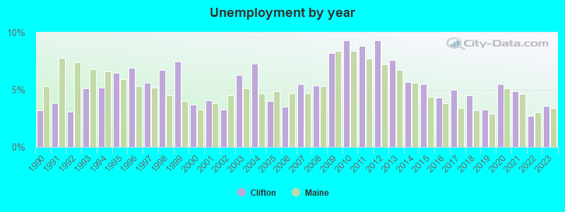
| Here: | 3.6% |
| Maine: | 3.4% |
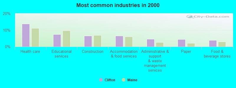
- Health care (13.8%)
- Educational services (7.4%)
- Construction (6.6%)
- Accommodation & food services (6.6%)
- Administrative & support & waste management services (4.7%)
- Paper (4.4%)
- Food & beverage stores (3.9%)
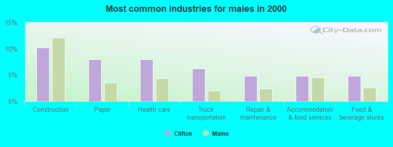
- Construction (10.2%)
- Paper (8.0%)
- Health care (8.0%)
- Truck transportation (6.2%)
- Repair & maintenance (4.9%)
- Accommodation & food services (4.9%)
- Food & beverage stores (4.9%)
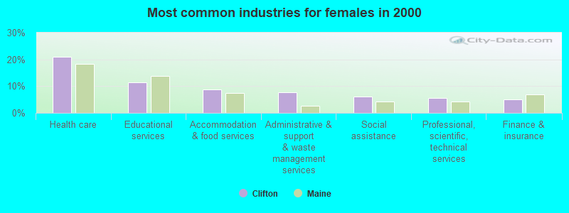
- Health care (20.9%)
- Educational services (11.5%)
- Accommodation & food services (8.8%)
- Administrative & support & waste management services (7.7%)
- Social assistance (6.0%)
- Professional, scientific, technical services (5.5%)
- Finance & insurance (4.9%)
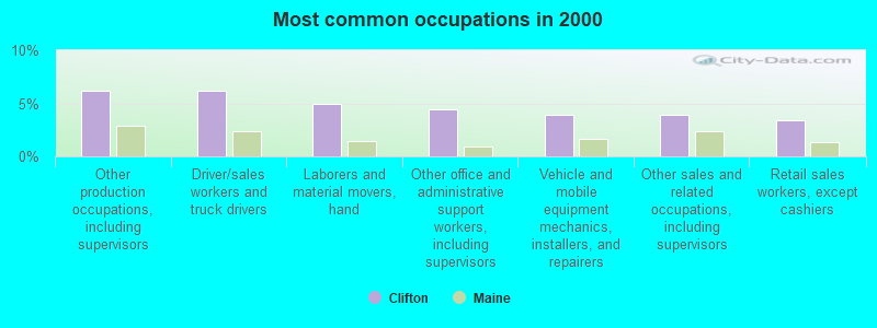
- Other production occupations, including supervisors (6.1%)
- Driver/sales workers and truck drivers (6.1%)
- Laborers and material movers, hand (4.9%)
- Other office and administrative support workers, including supervisors (4.4%)
- Vehicle and mobile equipment mechanics, installers, and repairers (3.9%)
- Other sales and related occupations, including supervisors (3.9%)
- Retail sales workers, except cashiers (3.4%)

- Driver/sales workers and truck drivers (11.1%)
- Other production occupations, including supervisors (10.2%)
- Vehicle and mobile equipment mechanics, installers, and repairers (7.1%)
- Laborers and material movers, hand (4.9%)
- Other sales and related occupations, including supervisors (4.4%)
- Carpenters (4.4%)
- Retail sales workers, except cashiers (3.6%)
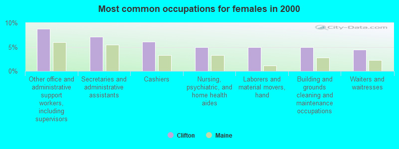
- Other office and administrative support workers, including supervisors (8.8%)
- Secretaries and administrative assistants (7.1%)
- Cashiers (6.0%)
- Nursing, psychiatric, and home health aides (4.9%)
- Laborers and material movers, hand (4.9%)
- Building and grounds cleaning and maintenance occupations (4.9%)
- Waiters and waitresses (4.4%)
Average climate in Clifton, Maine
Based on data reported by over 4,000 weather stations


(lower is better)
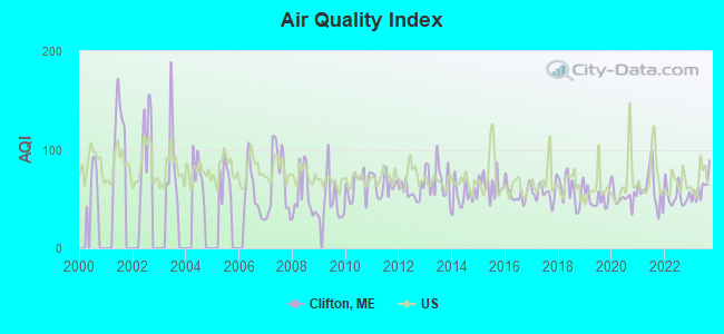
Air Quality Index (AQI) level in 2023 was 61.1. This is about average.
| City: | 61.1 |
| U.S.: | 72.6 |
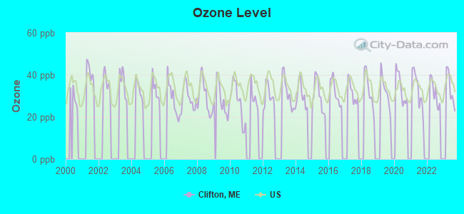
Ozone [ppb] level in 2023 was 33.6. This is about average. Closest monitor was 8.5 miles away from the city center.
| City: | 33.6 |
| U.S.: | 33.3 |
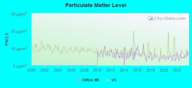
Particulate Matter (PM2.5) [µg/m3] level in 2023 was 5.62. This is significantly better than average. Closest monitor was 10.6 miles away from the city center.
| City: | 5.62 |
| U.S.: | 8.11 |
Earthquake activity:
Clifton-area historical earthquake activity is significantly above Maine state average. It is 82% smaller than the overall U.S. average.On 10/16/2012 at 23:12:25, a magnitude 4.7 (4.7 ML, Depth: 10.0 mi, Class: Light, Intensity: IV - V) earthquake occurred 134.6 miles away from the city center
On 4/20/2002 at 10:50:47, a magnitude 5.3 (5.3 ML, Depth: 3.0 mi, Class: Moderate, Intensity: VI - VII) earthquake occurred 255.1 miles away from Clifton center
On 4/20/2002 at 10:50:47, a magnitude 5.2 (5.2 MB, 4.2 MS, 5.2 MW, 5.0 MW) earthquake occurred 256.4 miles away from the city center
On 1/19/1982 at 00:14:42, a magnitude 4.7 (4.5 MB, 4.7 MD, 4.5 LG) earthquake occurred 177.2 miles away from the city center
On 10/7/1983 at 10:18:46, a magnitude 5.3 (5.1 MB, 5.3 LG, 5.1 ML) earthquake occurred 293.4 miles away from Clifton center
On 2/26/1999 at 03:38:43, a magnitude 3.8 (3.8 LG, Depth: 2.0 mi, Class: Light, Intensity: II - III) earthquake occurred 53.8 miles away from Clifton center
Magnitude types: regional Lg-wave magnitude (LG), body-wave magnitude (MB), duration magnitude (MD), local magnitude (ML), surface-wave magnitude (MS), moment magnitude (MW)
Natural disasters:
The number of natural disasters in Penobscot County (19) is greater than the US average (15).Major Disasters (Presidential) Declared: 11
Emergencies Declared: 7
Causes of natural disasters: Floods: 9, Storms: 8, Snows: 5, Heavy Rains: 2, Blizzard: 1, Hurricane: 1, Ice Storm: 1, Snowfall: 1, Wind: 1, Winter Storm: 1, Other: 2 (Note: some incidents may be assigned to more than one category).

Hospitals and medical centers near Clifton:
- NEW HOPE HOSPICE INC (Hospital, about 4 miles away; EDDINGTON, ME)
- TREATS FALLS HOUSE (Hospital, about 9 miles away; ORONO, ME)
- ORONO COMMONS (Nursing Home, about 10 miles away; ORONO, ME)
- MAINE VETERANS HOME - BANGOR (Nursing Home, about 11 miles away; BANGOR, ME)
- ELIZABETH LEVINSON CENTER (Hospital, about 11 miles away; BANGOR, ME)
- EASTERN MAINE MEDICAL CENTER Acute Care Hospitals (about 11 miles away; BANGOR, ME)
- HOSPICE OF EASTERN MAINE HHA (Home Health Center, about 12 miles away; BANGOR, ME)
Colleges/universities with over 2000 students nearest to Clifton:
- University of Maine (about 10 miles; Orono, ME; Full-time enrollment: 8,931)
- Husson University (about 14 miles; Bangor, ME; FT enrollment: 2,421)
- University of Maine at Augusta (about 71 miles; Augusta, ME; FT enrollment: 3,204)
- University of Maine at Farmington (about 81 miles; Farmington, ME; FT enrollment: 2,036)
- Southern Maine Community College (about 117 miles; South Portland, ME; FT enrollment: 4,666)
- University of Southern Maine (about 118 miles; Portland, ME; FT enrollment: 6,647)
- Saint Joseph's College of Maine (about 119 miles; Standish, ME; FT enrollment: 2,010)
Points of interest:
Notable locations in Clifton: Clifton Corners (A), Parks Pond Campground (B), Roosevelt Boy Scout Camp (C). Display/hide their locations on the map
Cemetery: Mount Pleasant Cemetery (1). Display/hide its location on the map
Lakes: Upper Springy Pond (A), Cedar Swamp Pond (B), Cranberry Pond (C), Fitts Pond (D), Little Burnt Pond (E), Middle Springy Pond (F), Parks Pond (G), Snowshoe Pond (H). Display/hide their locations on the map
Streams, rivers, and creeks: Goodwin Brook (A), Sibley Brook (B), Intervale Brook (C), Parks Pond Brook (D), Bradbury Brook (E). Display/hide their locations on the map
Drinking water stations with addresses in Clifton and their reported violations in the past:
PARKS POND CMPGRD (Population served: 188, Groundwater):Past health violations:Past monitoring violations:
- MCL, Monthly (TCR) - In MAY-2011, Contaminant: Coliform. Follow-up actions: St Formal NOV issued (MAY-26-2011), St Public Notif requested (MAY-26-2011), St Public Notif received (JUN-03-2011), St Compliance achieved (JUL-05-2011), St Public Notif received (JUL-05-2011)
- MCL, Monthly (TCR) - In JUL-2010, Contaminant: Coliform. Follow-up actions: St Public Notif requested (AUG-10-2010), St Formal NOV issued (AUG-10-2010), St Compliance achieved (MAY-31-2012), St Public Notif received (MAY-31-2012)
- MCL, Monthly (TCR) - In MAY-2006, Contaminant: Coliform. Follow-up actions: St Public Notif requested (JUN-01-2006), St Violation/Reminder Notice (JUN-01-2006), St Public Notif received (2 times from JUN-07-2006 to JUN-07-2006), St Compliance achieved (SEP-08-2008)
- One routine major monitoring violation
| This town: | 2.6 people |
| Maine: | 2.3 people |
| This town: | 74.0% |
| Whole state: | 62.9% |
| This town: | 10.1% |
| Whole state: | 9.4% |
Likely homosexual households (counted as self-reported same-sex unmarried-partner households)
- Lesbian couples: 0.3% of all households
- Gay men: 0.3% of all households
| This town: | 8.9% |
| Whole state: | 10.9% |
| This town: | 4.7% |
| Whole state: | 4.1% |
For population 15 years and over in Clifton:
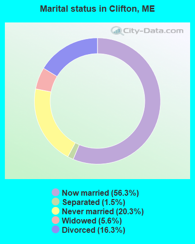
- Never married: 20.3%
- Now married: 56.3%
- Separated: 1.5%
- Widowed: 5.6%
- Divorced: 16.3%
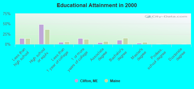
For population 25 years and over in Clifton:
- High school or higher: 85.7%
- Bachelor's degree or higher: 13.3%
- Graduate or professional degree: 3.3%
- Unemployed: 4.9%
- Mean travel time to work (commute): 28.9 minutes
| Here: | 9.0 |
| Maine average: | 11.2 |


Graphs represent county-level data. Detailed 2008 Election Results
Religion statistics for Clifton, ME (based on Penobscot County data)


| Religion | Adherents | Congregations |
|---|---|---|
| Catholic | 16,581 | 15 |
| Mainline Protestant | 9,715 | 59 |
| Evangelical Protestant | 7,523 | 80 |
| Other | 2,936 | 22 |
| Orthodox | 300 | 1 |
| None | 116,868 | - |
Food Environment Statistics:
| Penobscot County: | 2.29 / 10,000 pop. |
| Maine: | 2.80 / 10,000 pop. |
| Penobscot County: | 0.13 / 10,000 pop. |
| Maine: | 0.14 / 10,000 pop. |
| Penobscot County: | 2.56 / 10,000 pop. |
| Maine: | 2.20 / 10,000 pop. |
| Here: | 5.72 / 10,000 pop. |
| Maine: | 5.75 / 10,000 pop. |
| Here: | 7.41 / 10,000 pop. |
| Maine: | 11.02 / 10,000 pop. |
| Penobscot County: | 9.0% |
| Maine: | 8.2% |
| This county: | 28.0% |
| State: | 25.0% |
Strongest AM radio stations in Clifton:
- WABI (910 AM; 5 kW; BANGOR, ME; Owner: CLEAR CHANNEL BROADCASTING LICENSES, INC.)
- WZON (620 AM; 5 kW; BANGOR, ME; Owner: THE ZONE CORPORATION)
- WNZS (1340 AM; 1 kW; VEAZIE, ME; Owner: WATERFRONT COMMUNICATIONS INC.)
- WDEA (1370 AM; 5 kW; ELLSWORTH, ME; Owner: CUMULUS LICENSING CORP.)
- WSKW (1160 AM; 10 kW; SKOWHEGAN, ME; Owner: MOUNTAIN WIRELESS, INCORPORATED)
- WRKO (680 AM; 50 kW; BOSTON, MA; Owner: ENTERCOM BOSTON LICENSE, LLC)
- WTME (780 AM; 10 kW; RUMFORD, ME; Owner: MOUNTAIN VALLEY BROADCASTING, INC.)
- WEEI (850 AM; 50 kW; BOSTON, MA; Owner: ENTERCOM BOSTON LICENSE, LLC)
- WBZ (1030 AM; 50 kW; BOSTON, MA; Owner: INFINITY BROADCASTING OPERATIONS, INC.)
- WCRN (830 AM; 50 kW; WORCESTER, MA; Owner: CARTER BROADCASTING CORPORATION)
- WNNZ (640 AM; 50 kW; WESTFIELD, MA; Owner: CLEAR CHANNEL BROADCASTING LICENSES, INC.)
- WKOX (1200 AM; 50 kW; FRAMINGHAM, MA; Owner: CAPSTAR TX LIMITED PARTNERSHIP)
- WALE (990 AM; 50 kW; GREENVILLE, RI; Owner: NORTH AMERICAN BROADCASTING CO., INC.)
Strongest FM radio stations in Clifton:
- WMEH (90.9 FM; BANGOR, ME; Owner: MAINE PUBLIC BROADCASTING CORPORATION)
- WEZQ (92.9 FM; BANGOR, ME; Owner: CUMULUS LICENSING CORP.)
- WWMJ (95.7 FM; ELLSWORTH, ME; Owner: CUMULUS LICENSING CORP.)
- WKIT-FM (100.3 FM; BREWER, ME; Owner: THE ZONE CORPORATION)
- WHCF (88.5 FM; BANGOR, ME; Owner: BANGOR BAPTIST CHURCH)
- WVOM (103.9 FM; HOWLAND, ME; Owner: CLEAR CHANNEL BROADCASTING LICENSES, INC.)
- WBFB (104.7 FM; BELFAST, ME; Owner: CLEAR CHANNEL BROADCASTING LICENSES, INC.)
- WWBX (97.1 FM; BANGOR, ME; Owner: CLEAR CHANNEL BROADCASTING LICENSES, INC.)
- WBZN (107.3 FM; OLD TOWN, ME; Owner: CUMULUS LICENSING CORP.)
- WNSX (97.7 FM; WINTER HARBOR, ME; Owner: CLEAR CHANNEL BROADCASTING LICENSES, INC.)
- WERU-FM (89.9 FM; BLUE HILL, ME; Owner: SALT POND COMMUNITY B/C COMPANY)
- WFZX (101.7 FM; SEARSPORT, ME; Owner: CLEAR CHANNEL BROADCASTING LICENSES, INC.)
- WLKE (99.1 FM; BAR HARBOR, ME; Owner: CLEAR CHANNEL BROADCASTING LICENSES, INC.)
- WQCB (106.5 FM; BREWER, ME; Owner: CUMULUS LICENSING CORP.)
- WMEB-FM (91.9 FM; ORONO, ME; Owner: UNIVERSITY OF MAINE SYSTEM)
- WBQI (107.7 FM; BAR HARBOR, ME; Owner: MARINER BROADCASTING, L.P.)
- W275AE (102.9 FM; BANGOR, ME; Owner: SALT POND COMMUNITY BROADCASTING, INC.)
TV broadcast stations around Clifton:
- WMEB-TV (Channel 12; ORONO, ME; Owner: MAINE PUBLIC BROADCASTING CORPORATION)
- W66CL (Channel 66; BANGOR, ME; Owner: MS COMMUNICATIONS, LLC)
- WBAN-LP (Channel 9; BANGOR, ME; Owner: BANGOR MEDIA GROUP, LLC)
- WVII-TV (Channel 7; BANGOR, ME; Owner: BANGOR COMMUNICATIONS, INC.)
- WFVX-LP (Channel 22; BANGOR, ME; Owner: ROCKFLEET BROADCASTING III, LLC)
- W39CC (Channel 39; BANGOR, ME; Owner: MS COMMUNICATIONS, LLC)
- W42BZ (Channel 42; BANGOR, ME; Owner: MS COMMUNICATIONS, LLC)
- W50BX (Channel 50; BANGOR, ME; Owner: MS COMMUNICATIONS, LLC)
- W54CG (Channel 54; BANGOR, ME; Owner: MS COMMUNICATIONS, LLC)
- WLBZ (Channel 2; BANGOR, ME; Owner: PACIFIC AND SOUTHERN COMPANY, INC.)
- WBGR-LP (Channel 33; BANGOR/DEDHAM, ME; Owner: MAINE FAMILY BROADCASTING, INC.)
- WCKD-LP (Channel 30; BANGOR/DEDHAM, ME; Owner: J. MCLEOD, ME FAMILY B/CING., INC.)
- WABI-TV (Channel 5; BANGOR, ME; Owner: COMMUNITY BROADCASTING SERVICE)
Clifton fatal accident list:
Dec 16, 2013 04:45 PM, Sr-180, Lat: 44.783103, Lon: -68.491106, Vehicles: 2, Persons: 3, Fatalities: 1
Aug 14, 2010 11:10 AM, Sr-9, Lat: 44.820447, Lon: -68.467000, Vehicles: 2, Persons: 3, Fatalities: 1
Apr 30, 2006 05:04 PM, Us-9, Lat: 44.800140, Lon: -68.548430, Vehicles: 1, Persons: 1, Fatalities: 1, Drunk persons involved: 1
May 24, 2006 02:45 AM, Sr-9, Lat: 44.819210, Lon: -68.523150, Vehicles: 1, Persons: 2, Fatalities: 1
Jul 15, 2006 04:46 AM, Sr-9, Lat: 44.816000, Lon: -68.459800, Vehicles: 1, Persons: 1, Fatalities: 1
Feb 5, 2003 05:59 AM, Us-9, Vehicles: 2, Persons: 2, Fatalities: 1
FCC Registered Cell Phone Towers:
1- Clifton Cell Site 3.5 Miles West Of (Lat: 44.829806 Lon: -68.463361), Structure height: 99.1 m, Call Sign: KNKA710
Assigned Frequencies: 869.040 MHz, 890.010 MHz, 824.040 MHz, 845.010 MHzGrant Date: 01/03/2018, Expiration Date: 01/22/2028Registrant: Wilkinson Barker Knauer, LLP, 1800 M Street Nw, Suite 800n, Washington, DC 20036, Phone: (202) 383-3420, Fax: (202) 783-5851, Email:
FCC Registered Antenna Towers:
5- PETER M CONNOLLY, 3.5 Mi W (Lat: 44.829167 Lon: -68.464167), Type: 99.1, Overall height: 91.4 m, Registrant: Holland & Knight LLP, Pconnoll@hklaw.Com, , Washi-ngton, Phone: (202) 862-5989
- STEVEN T CAMPBELL, 3.5 Mi W (Lat: 44.829167 Lon: -68.464167), Type: 99.1, Structure height: 23019 m, Overall height: 91.4 m, Registrant: Holland & Knight LLP, Peter.Connolly@hklaw.Com, , Washi-ngton, Phone: (202) 955-3000
- Kristopher D Williams, Peak Mountain Off Fire Road 32 (Lat: 44.829306 Lon: -68.464139), Type: 95.4, Structure height: 23019 m, Overall height: 92 m, Licensee ID: C, Registrant: United States Cellular Corporation, Regulatoryaffairs@uscellular.Com, , Chica-go, Phone: (773) 399-8900
- Kristopher D Williams, Peak Mountain Off Fire Road 32 (Lat: 44.829306 Lon: -68.464139), Type: 95.4, Structure height: 23019 m, Overall height: 92 m, Registrant: Holland & Knight LLP, Peter.Connolly@hklaw.Com, , Washi-ngton, Phone: (202) 955-3000
- 3.5 Mi W (Lat: 44.829167 Lon: -68.464167), Type: 99.1, Overall height: 91.4 m, Registrant: Bangor Cellular Telephone LP, Linda.Hartman@koteen.Com, , Washi-ngton, Phone: (202) 467-5700
FCC Registered Broadcast Land Mobile Towers:
2- Lat: 44.850000 Lon: -68.412222, Call Sign: WPSP603,
Assigned Frequencies: 153.590 MHz, Grant Date: 04/09/2021, Expiration Date: 07/05/2031, Certifier: Dan Longfellow, Registrant: Versant Power, 970 Illinois Avenue, Bangor, ME 04402-0932, Phone: (207) 973-2546, Email:
- Clifton, Rte 9 (Lat: 44.820833 Lon: -68.467778), Type: Tower, Structure height: 5 m, Overall height: 6 m, Call Sign: WPTR625,
Assigned Frequencies: 453.400 MHz, Grant Date: 09/04/2021, Expiration Date: 11/30/2031, Certifier: William Plante, Registrant: State Of Maine, O.I.T., Radio Operations, 66 Industrial Drive, Augusta, ME 04333-0147, Phone: (207) 624-9990, Email:
FCC Registered Microwave Towers:
2- CLIFTON, Peak Mountain Off Fire Road 32 (Lat: 44.829306 Lon: -68.464139), Type: Gtower, Structure height: 92 m, Overall height: 95.4 m, Call Sign: WPNL650,
Assigned Frequencies: 6197.24 MHz, 6271.36 MHz, Grant Date: 05/01/2018, Expiration Date: 04/01/2028, Registrant: Wilkinson Barker Knauer, LLP, 1800 M Street Nw, Suite 800n, Washington, DC 20036, Phone: (202) 383-3420, Fax: (202) 783-5851, Email:
- 4BG1498A, Peak Mountain Off Fire Road 32 (Lat: 44.829306 Lon: -68.464139), Type: Gtower, Structure height: 92 m, Overall height: 95.4 m, Call Sign: WRUY559,
Assigned Frequencies: 11225.0 MHz, 11265.0 MHz, 11225.0 MHz, 11265.0 MHz, 11225.0 MHz, 11265.0 MHz, 11225.0 MHz, 11265.0 MHz, 11225.0 MHz, 11265.0 MHz... (+38 more), Grant Date: 10/18/2022, Expiration Date: 10/18/2032, Certifier: Jenny Knopf, Registrant: T-Mobile Usa, Inc., 12920 Se 38th Street, Bellevue, WA 98006, Phone: (425) 383-8401, Fax: (425) 383-4040, Email:
FCC Registered Amateur Radio Licenses:
4- Call Sign: AA2KL, Licensee ID: L00506432, Grant Date: 04/24/2002, Expiration Date: 07/21/2012, Cancellation Date: 07/22/2014, Registrant: Robert C De Chaine, 1078 Airline Rd, Clifton, ME 04428
- Call Sign: K1DVW, Grant Date: 03/25/1998, Expiration Date: 03/25/2008, Cancellation Date: 03/26/2010, Registrant: Lawrence C Parlee, 257 Scotts Point Rd, Clifton, ME 04428-6019
- Call Sign: KB1AFC, Grant Date: 12/08/1994, Expiration Date: 06/16/2002, Cancellation Date: 06/17/2004, Registrant: Mike W Roberts, 299 Rebel Hill Rd, Clifton, ME 04428
- Call Sign: KB1TLD, Licensee ID: L01535645, Grant Date: 09/16/2019, Expiration Date: 12/11/2029, Certifier: Ervin M Davis Ii, Registrant: Ervin M Davis Ii, 446 Rebel Hill Rd, Clifton, ME 04428
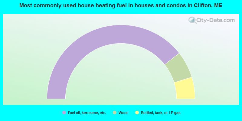
- 78.8%Fuel oil, kerosene, etc.
- 11.7%Wood
- 9.5%Bottled, tank, or LP gas
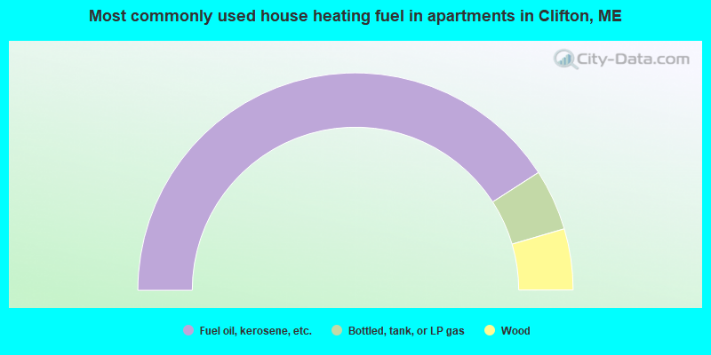
- 81.8%Fuel oil, kerosene, etc.
- 9.1%Bottled, tank, or LP gas
- 9.1%Wood
Clifton compared to Maine state average:
- Unemployed percentage below state average.
- Hispanic race population percentage below state average.
- Foreign-born population percentage significantly below state average.
- Renting percentage below state average.
- Length of stay since moving in significantly above state average.
- Number of rooms per house significantly below state average.
- House age significantly below state average.
- Percentage of population with a bachelor's degree or higher below state average.
State forum archive:

|
Total of 2 patent applications in 2008-2024.