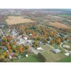
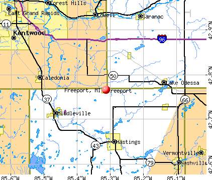
Freeport, Michigan
Submit your own pictures of this village and show them to the world
- OSM Map
- General Map
- Google Map
- MSN Map
Population change since 2000: +23.4%
 |
| Males: 254 | |
| Females: 294 |
| Median resident age: | 27.9 years |
| Michigan median age: | 40.3 years |
Zip codes: 49325.
| Freeport: | $63,423 |
| MI: | $66,986 |
Estimated per capita income in 2022: $25,550 (it was $18,684 in 2000)
Freeport village income, earnings, and wages data
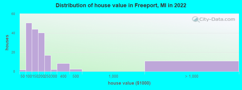
Estimated median house or condo value in 2022: $151,981 (it was $78,900 in 2000)
| Freeport: | $151,981 |
| MI: | $224,400 |
Mean prices in 2022: all housing units: $208,787; detached houses: $213,571; mobile homes: $110,321
Median gross rent in 2022: $938.
(10.9% for White Non-Hispanic residents, 37.1% for Hispanic or Latino residents, 33.3% for two or more races residents)
Compare current foreclosures near Freeport, MI:
| Photo | Address | Area | Beds / Baths | Price | Details |
|---|---|---|---|---|---|

|
#1
N Broadway Rd
Freeport, MI 49325
|
2,172 sq. feet
|
1 baths - beds |
show details | |

|
#2
Sabal Pointe Dr SE
Grand Rapids, MI 49546
|
1,745 sq. feet
|
2 baths 2 beds |
show details | |

|
#3
68th St SE
Caledonia, MI 49316
|
1,177 sq. feet
|
1 baths 3 beds |
show details | |

|
#4
Hunt St
Lowell, MI 49331
|
1,464 sq. feet
|
2 baths 4 beds |
show details | |

|
#5
Grand St
Hastings, MI 49058
|
1,796 sq. feet
|
3 baths 3 beds |
show details | |

|
#6
Alyssum Dr SE
Grand Rapids, MI 49512
|
1,560 sq. feet
|
2 baths 3 beds |
show details | |

|
#7
W Clinton St
Hastings, MI 49058
|
1,604 sq. feet
|
2 baths 3 beds |
show details | |

|
#8
W Garbow Rd
Middleville, MI 49333
|
2,521 sq. feet
|
2 baths 3 beds |
show details | |

|
#9
Lawrence Rd
Nashville, MI 49073
|
2,560 sq. feet
|
2 baths 5 beds |
show details | |

|
#10
S Market St
Hastings, MI 49058
|
1,455 sq. feet
|
1 baths 3 beds |
show details |
| Photo | Address | Area | Beds / Baths | Price | Details |
|---|---|---|---|---|---|

|
#11
S Main St
Nashville, MI 49073
|
2,700 sq. feet
|
5 baths 5 beds |
show details | |

|
#12
N Main St
Nashville, MI 49073
|
7,832 sq. feet
|
7 baths 6 beds |
show details | |

|
#13
Thatcher St
Woodland, MI 48897
|
1,200 sq. feet
|
1 baths 3 beds |
show details | |

|
#14
S Main St
Woodland, MI 48897
|
1,376 sq. feet
|
1 baths 3 beds |
show details | |

|
#15
Bentbrook St SE
Grand Rapids, MI 49508
|
- sq. feet
|
2 baths 3 beds |
show details | |

|
#16
Hilltop Dr
Middleville, MI 49333
|
1,008 sq. feet
|
1 baths 3 beds |
show details | |

|
#17
Coats Grove Rd
Hastings, MI 49058
|
1,668 sq. feet
|
2 baths 1 beds |
show details | |

|
#18
S Church St
Hastings, MI 49058
|
704 sq. feet
|
1 baths 2 beds |
show details | |

|
#19
W Walnut St
Hastings, MI 49058
|
1,330 sq. feet
|
1 baths 3 beds |
show details | |

|
#20
S M 37 Hwy
Hastings, MI 49058
|
1,146 sq. feet
|
2 baths 2 beds |
show details |
| Photo | Address | Area | Beds / Baths | Price | Details |
|---|---|---|---|---|---|

|
#21
N Michigan Ave
Hastings, MI 49058
|
1,170 sq. feet
|
1 baths 2 beds |
show details | |

|
#22
S State St
Nashville, MI 49073
|
2,626 sq. feet
|
4 baths 4 beds |
show details | |

|
#23
Cork St
Wayland, MI 49348
|
2,053 sq. feet
|
2 baths - beds |
show details | |

|
#24
141st Ave
Wayland, MI 49348
|
2,305 sq. feet
|
2 baths - beds |
show details | |

|
#25
W Parmalee Rd
Middleville, MI 49333
|
1,570 sq. feet
|
2 baths - beds |
show details | |

|
#26
Mill St
Saranac, MI 48881
|
2,258 sq. feet
|
1 baths - beds |
show details | |

|
#27
E Francis St
Nashville, MI 49073
|
1,164 sq. feet
|
1 baths - beds |
show details | |

|
#28
Loehrs Landing Dr
Hastings, MI 49058
|
936 sq. feet
|
1 baths - beds |
show details | |

|
#29
Shilton Rd
Portland, MI 48875
|
1,200 sq. feet
|
1 baths - beds |
show details | |

|
#30
142nd Ave
Wayland, MI 49348
|
1,496 sq. feet
|
2 baths - beds |
show details |
| Photo | Address | Area | Beds / Baths | Price | Details |
|---|---|---|---|---|---|

|
#31
Goodemoote Rd
Portland, MI 48875
|
1,136 sq. feet
|
1 baths - beds |
show details | |

|
#32
Fawn Ridge Dr
Lowell, MI 49331
|
960 sq. feet
|
1 baths - beds |
show details | |

|
#33
W Peck Lake Rd
Lowell, MI 49331
|
1,200 sq. feet
|
4 baths - beds |
show details | |

|
#34
W Ferney St
Clarksville, MI 48815
|
1,696 sq. feet
|
2 baths - beds |
show details | |

|
#35
Mcarthur St
Lake Odessa, MI 48849
|
1,810 sq. feet
|
1 baths - beds |
show details | |

|
#36
Johnson St
Lake Odessa, MI 48849
|
960 sq. feet
|
1 baths - beds |
show details | |

|
#37
Park Dr
Wayland, MI 49348
|
1,486 sq. feet
|
2 baths - beds |
show details | |

|
#38
Mixer Rd
Hastings, MI 49058
|
800 sq. feet
|
1 baths - beds |
show details | |

|
#39
N Whitneyville Rd
Middleville, MI 49333
|
1,595 sq. feet
|
2 baths - beds |
show details | |

|
#40
Pine Meadow Dr SE Apt 102
Grand Rapids, MI 49512
|
- sq. feet
|
- baths - beds |
show details |
| Photo | Address | Area | Beds / Baths | Price | Details |
|---|---|---|---|---|---|

|
#41
W Fieldstone Hills Dr SE Apt 10
Caledonia, MI 49316
|
- sq. feet
|
- baths - beds |
show details | |

|
#42
Breezewood Dr SE
Grand Rapids, MI 49512
|
- sq. feet
|
- baths - beds |
show details | |

|
#43
Forest Creek Dr SE Apt 1c
Grand Rapids, MI 49512
|
- sq. feet
|
- baths - beds |
show details | |

|
#44
W Mill Run SE
Caledonia, MI 49316
|
- sq. feet
|
- baths - beds |
show details | |

|
#45
W Rosebud Ct SE # 5
Grand Rapids, MI 49512
|
- sq. feet
|
- baths - beds |
show details | |

|
#46
S Creek Dr SE Apt 201
Grand Rapids, MI 49512
|
- sq. feet
|
- baths - beds |
show details | |

|
#47
Hunters Ridge Dr Se, Apt 8
Grand Rapids, MI 49512
|
- sq. feet
|
- baths - beds |
show details | |

|
#48
Sparks Rd
Saranac, MI 48881
|
- sq. feet
|
- baths - beds |
show details | |

|
#49
N Breton Ct SE Apt 105
Grand Rapids, MI 49508
|
- sq. feet
|
- baths - beds |
show details | |

|
Check over 1 million property listings on Foreclosure.com!
|
browse all offers | |||


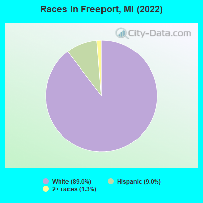
- 63389.0%White alone
- 649.0%Hispanic
- 91.3%Two or more races
Races in Freeport detailed stats: ancestries, foreign born residents, place of birth
According to our research of Michigan and other state lists, there were 10 registered sex offenders living in Freeport, Michigan as of April 26, 2024.
The ratio of all residents to sex offenders in Freeport is 46 to 1.
Full-time law enforcement employees in 2018, including police officers: 1 (1 officers - 1 male; 0 female).
| Officers per 1,000 residents here: | 2.03 |
| Michigan average: | 1.85 |
 Recent articles from our blog. Our writers, many of them Ph.D. graduates or candidates, create easy-to-read articles on a wide variety of topics.


 | Possible move from Texas to Saginaw area (52 replies) |
| Pics of Spectacular Michigan (2204 replies) |
| small town search in MI (15 replies) |
| Middleville (3 replies) |
Latest news from Freeport, MI collected exclusively by city-data.com from local newspapers, TV, and radio stations
Ancestries: American (23.5%), German (12.4%), English (9.7%), Scottish (4.4%), Dutch (4.0%), French Canadian (3.5%).
Current Local Time: EST time zone
Elevation: 780 feet
Land area: 0.77 square miles.
Population density: 711 people per square mile (low).
2 residents are foreign born
| This village: | 0.3% |
| Michigan: | 6.9% |
Median real estate property taxes paid for housing units with mortgages in 2022: $1,815 (1.1%)
Median real estate property taxes paid for housing units with no mortgage in 2022: $2,107 (1.5%)
Nearest city with pop. 50,000+: Wyoming, MI  (21.6 miles , pop. 69,368).
Nearest city with pop. 200,000+: Detroit, MI (115.6 miles , pop. 951,270).
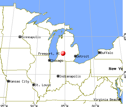
Nearest city with pop. 1,000,000+: Chicago, IL (136.9 miles , pop. 2,896,016).
Nearest cities:
), Latitude: 42.77 N, Longitude: 85.31 W
Area code: 616

| Here: | 3.2% |
| Michigan: | 3.5% |
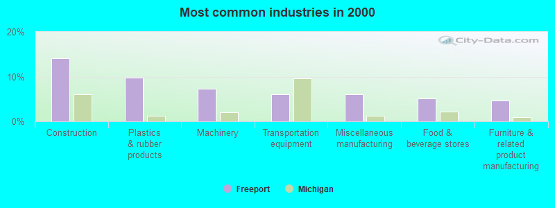
- Construction (14.1%)
- Plastics & rubber products (9.8%)
- Machinery (7.3%)
- Transportation equipment (6.0%)
- Miscellaneous manufacturing (6.0%)
- Food & beverage stores (5.1%)
- Furniture & related product manufacturing (4.7%)
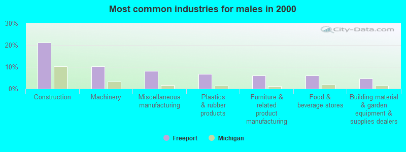
- Construction (21.1%)
- Machinery (10.2%)
- Miscellaneous manufacturing (8.2%)
- Plastics & rubber products (6.8%)
- Furniture & related product manufacturing (6.1%)
- Food & beverage stores (6.1%)
- Building material & garden equipment & supplies dealers (4.8%)

- Plastics & rubber products (14.9%)
- Transportation equipment (12.6%)
- Health care (11.5%)
- Social assistance (11.5%)
- Accommodation & food services (8.0%)
- Administrative & support & waste management services (5.7%)
- Department & other general merchandise stores (4.6%)
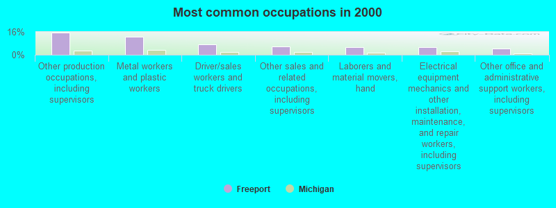
- Other production occupations, including supervisors (15.4%)
- Metal workers and plastic workers (12.4%)
- Driver/sales workers and truck drivers (7.3%)
- Other sales and related occupations, including supervisors (6.0%)
- Laborers and material movers, hand (5.6%)
- Electrical equipment mechanics and other installation, maintenance, and repair workers, including supervisors (5.1%)
- Other office and administrative support workers, including supervisors (4.3%)
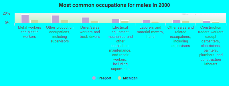
- Metal workers and plastic workers (17.7%)
- Other production occupations, including supervisors (15.6%)
- Driver/sales workers and truck drivers (11.6%)
- Electrical equipment mechanics and other installation, maintenance, and repair workers, including supervisors (8.2%)
- Laborers and material movers, hand (6.1%)
- Other sales and related occupations, including supervisors (5.4%)
- Construction traders workers except carpenters, electricians, painters, plumbers, and construction laborers (4.8%)
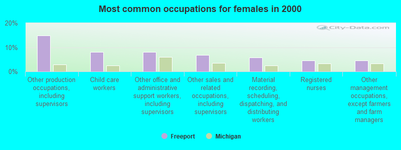
- Other production occupations, including supervisors (14.9%)
- Child care workers (8.0%)
- Other office and administrative support workers, including supervisors (8.0%)
- Other sales and related occupations, including supervisors (6.9%)
- Material recording, scheduling, dispatching, and distributing workers (5.7%)
- Registered nurses (4.6%)
- Other management occupations, except farmers and farm managers (4.6%)
Average climate in Freeport, Michigan
Based on data reported by over 4,000 weather stations


(lower is better)
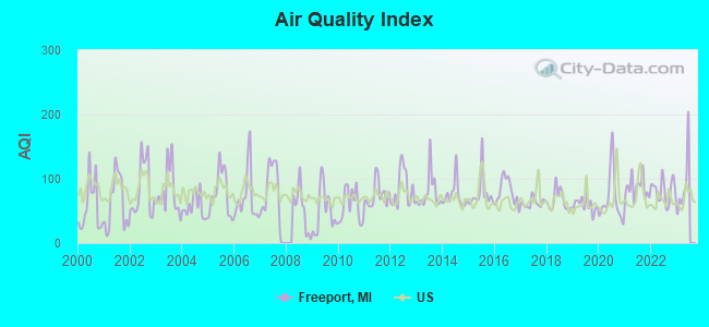
Air Quality Index (AQI) level in 2022 was 81.7. This is about average.
| City: | 81.7 |
| U.S.: | 72.6 |
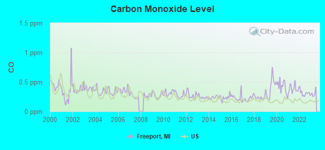
Carbon Monoxide (CO) [ppm] level in 2022 was 0.310. This is worse than average. Closest monitor was 23.4 miles away from the city center.
| City: | 0.310 |
| U.S.: | 0.251 |
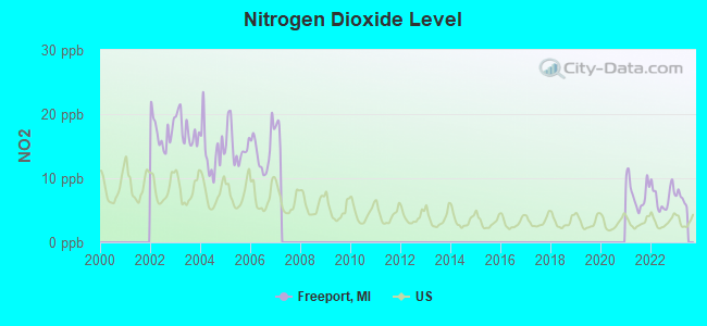
Nitrogen Dioxide (NO2) [ppb] level in 2022 was 7.01. This is worse than average. Closest monitor was 22.6 miles away from the city center.
| City: | 7.01 |
| U.S.: | 5.11 |
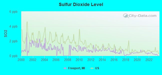
Sulfur Dioxide (SO2) [ppb] level in 2022 was 0.321. This is significantly better than average. Closest monitor was 22.6 miles away from the city center.
| City: | 0.321 |
| U.S.: | 1.515 |
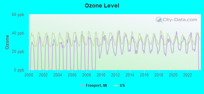
Ozone [ppb] level in 2022 was 28.5. This is about average. Closest monitor was 23.4 miles away from the city center.
| City: | 28.5 |
| U.S.: | 33.3 |
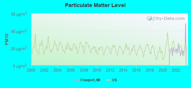
Particulate Matter (PM10) [µg/m3] level in 2022 was 17.3. This is about average. Closest monitor was 22.8 miles away from the city center.
| City: | 17.3 |
| U.S.: | 19.2 |

Particulate Matter (PM2.5) [µg/m3] level in 2022 was 9.44. This is about average. Closest monitor was 22.8 miles away from the city center.
| City: | 9.44 |
| U.S.: | 8.11 |
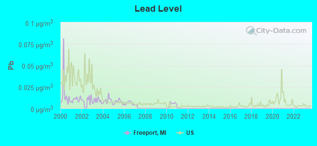
Lead (Pb) [µg/m3] level in 2010 was 0.00613. This is significantly better than average. Closest monitor was 18.6 miles away from the city center.
| City: | 0.00613 |
| U.S.: | 0.00931 |
Tornado activity:
Freeport-area historical tornado activity is slightly above Michigan state average. It is 35% greater than the overall U.S. average.
On 4/3/1956, a category F5 (max. wind speeds 261-318 mph) tornado 39.1 miles away from the Freeport village center killed 18 people and injured 340 people and caused between $50,000 and $500,000 in damages.
On 4/2/1977, a category F4 (max. wind speeds 207-260 mph) tornado 27.6 miles away from the village center killed one person and injured 44 people and caused between $500,000 and $5,000,000 in damages.
Earthquake activity:
Freeport-area historical earthquake activity is significantly above Michigan state average. It is 28% smaller than the overall U.S. average.On 5/2/2015 at 16:23:07, a magnitude 4.2 (4.2 MW, Depth: 2.8 mi, Class: Light, Intensity: IV - V) earthquake occurred 37.1 miles away from the city center
On 1/31/1986 at 16:46:43, a magnitude 5.0 (5.0 MB, Class: Moderate, Intensity: VI - VII) earthquake occurred 227.5 miles away from the city center
On 9/25/1998 at 19:52:52, a magnitude 5.2 (4.8 MB, 4.3 MS, 5.2 LG, 4.5 MW, Depth: 3.1 mi) earthquake occurred 267.2 miles away from Freeport center
On 4/18/2008 at 09:36:59, a magnitude 5.4 (5.1 MB, 4.8 MS, 5.4 MW, 5.2 MW) earthquake occurred 327.5 miles away from the city center
On 7/12/1986 at 08:19:37, a magnitude 4.5 (4.5 MB) earthquake occurred 161.6 miles away from Freeport center
On 6/10/1987 at 23:48:54, a magnitude 5.1 (4.9 MB, 4.4 MS, 4.6 MS, 5.1 LG) earthquake occurred 304.2 miles away from the city center
Magnitude types: regional Lg-wave magnitude (LG), body-wave magnitude (MB), surface-wave magnitude (MS), moment magnitude (MW)
Natural disasters:
The number of natural disasters in Barry County (12) is smaller than the US average (15).Major Disasters (Presidential) Declared: 6
Emergencies Declared: 5
Causes of natural disasters: Storms: 5, Floods: 4, Tornadoes: 3, Snowstorms: 2, Winter Storms: 2, Blizzard: 1, Freeze: 1, Hurricane: 1, Wind: 1, Other: 1 (Note: some incidents may be assigned to more than one category).

Hospitals and medical centers near Freeport:
- MAGNUMCARE OF HASTINGS, LLC (Nursing Home, about 8 miles away; HASTINGS, MI)
- PENNOCK HOMECARE SERVICES (Home Health Center, about 9 miles away; HASTINGS, MI)
- PENNOCK HOSPITAL Acute Care Hospitals (about 9 miles away; HASTINGS, MI)
- BARRY COUNTY MEDICAL CARE FACILITY (Nursing Home, about 12 miles away; HASTINGS, MI)
- THORNAPPLE MANOR (Nursing Home, about 12 miles away; HASTINGS, MI)
- LAURELS OF KENT (THE) (Nursing Home, about 12 miles away; LOWELL, MI)
- AT HOME REHAB (Home Health Center, about 14 miles away; GRAND RAPIDS, MI)
Colleges/universities with over 2000 students nearest to Freeport:
- Davenport University (about 13 miles; Grand Rapids, MI; Full-time enrollment: 6,955)
- Calvin College (about 18 miles; Grand Rapids, MI; FT enrollment: 4,117)
- Cornerstone University (about 21 miles; Grand Rapids, MI; FT enrollment: 2,573)
- Grand Rapids Community College (about 23 miles; Grand Rapids, MI; FT enrollment: 11,296)
- Kellogg Community College (about 31 miles; Battle Creek, MI; FT enrollment: 4,078)
- Grand Valley State University (about 33 miles; Allendale, MI; FT enrollment: 21,982)
- Western Michigan University (about 37 miles; Kalamazoo, MI; FT enrollment: 20,840)
Points of interest:
Notable locations in Freeport: Freeport District Library (A), Freeport Area Volunteer Fire Department (B), Freeport Village Hall (C), Freeport Police Department (D). Display/hide their locations on the map
Churches in Freeport include: Freeport United Brethren Church (A), Freeport United Methodist Church (B). Display/hide their locations on the map
Cemetery: Freeport Cemetery (1). Display/hide its location on the map
Tourist attraction: Cheesebrough (Museums; 216 Division Street).
Birthplace of: Allen Steckle - Football player and coach.
Drinking water stations with addresses in Freeport and their reported violations in the past:
FREEPORT (Population served: 483, Groundwater):Past monitoring violations:
- 2 routine major monitoring violations
Drinking water stations with addresses in Freeport that have no violations reported:
- HOPE CHURCH OF THE BRETHREN (Population served: 50, Primary Water Source Type: Groundwater)
| This village: | 2.7 people |
| Michigan: | 2.5 people |
| This village: | 70.1% |
| Whole state: | 66.0% |
| This village: | 11.9% |
| Whole state: | 6.4% |
Likely homosexual households (counted as self-reported same-sex unmarried-partner households)
- Lesbian couples: 0.0% of all households
- Gay men: 0.6% of all households
For population 15 years and over in Freeport:
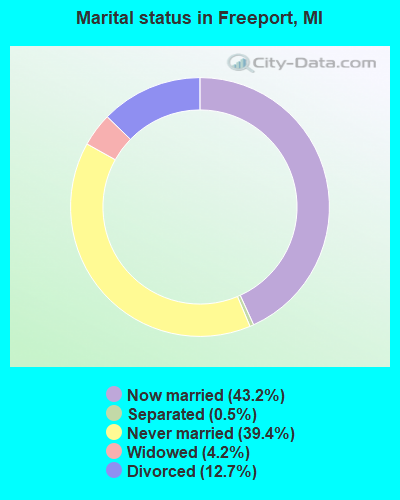
- Never married: 39.4%
- Now married: 43.2%
- Separated: 0.5%
- Widowed: 4.2%
- Divorced: 12.7%
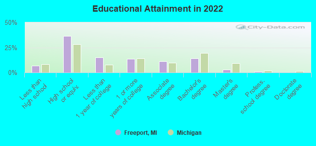
For population 25 years and over in Freeport:
- High school or higher: 93.1%
- Bachelor's degree or higher: 17.2%
- Graduate or professional degree: 3.7%
- Unemployed: 2.1%
- Mean travel time to work (commute): 25.2 minutes
| Here: | 7.6 |
| Michigan average: | 11.0 |
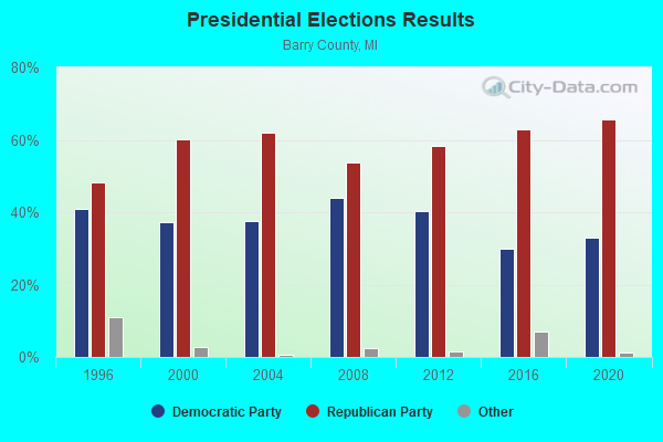
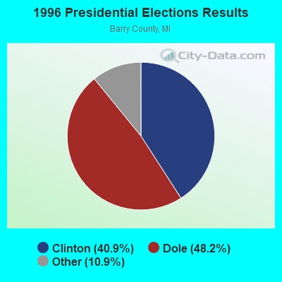
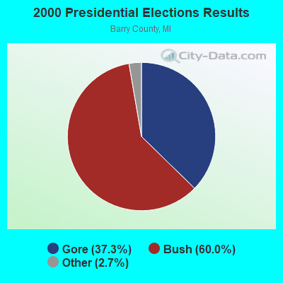

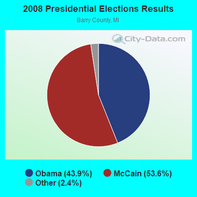
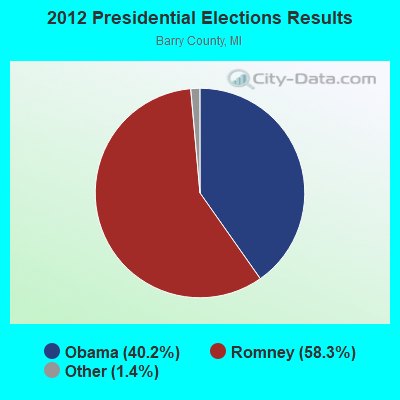
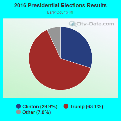

Graphs represent county-level data. Detailed 2008 Election Results
Religion statistics for Freeport, MI (based on Barry County data)
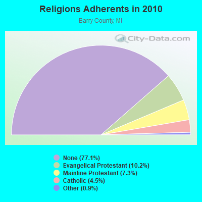
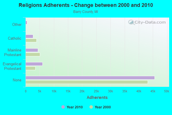
| Religion | Adherents | Congregations |
|---|---|---|
| Evangelical Protestant | 6,020 | 30 |
| Mainline Protestant | 4,330 | 20 |
| Catholic | 2,681 | 4 |
| Other | 526 | 3 |
| None | 45,616 | - |
Food Environment Statistics:
| Barry County: | 2.20 / 10,000 pop. |
| State: | 2.34 / 10,000 pop. |
| Here: | 1.18 / 10,000 pop. |
| Michigan: | 1.52 / 10,000 pop. |
| Barry County: | 2.88 / 10,000 pop. |
| Michigan: | 2.99 / 10,000 pop. |
| Barry County: | 6.43 / 10,000 pop. |
| State: | 6.80 / 10,000 pop. |
| Here: | 9.1% |
| Michigan: | 9.7% |
| Barry County: | 30.1% |
| State: | 29.7% |
| Barry County: | 11.4% |
| State: | 13.4% |
Health and Nutrition:
| This city: | 46.2% |
| Michigan: | 50.3% |
| Freeport: | 39.7% |
| Michigan: | 47.9% |
| Freeport: | 29.2 |
| Michigan: | 28.7 |
| Freeport: | 22.2% |
| Michigan: | 20.6% |
| This city: | 12.9% |
| Michigan: | 10.4% |
| Freeport: | 6.7 |
| State: | 6.8 |
| This city: | 35.1% |
| Michigan: | 34.1% |
| Freeport: | 52.6% |
| Michigan: | 57.0% |
| Freeport: | 76.5% |
| State: | 79.6% |
More about Health and Nutrition of Freeport, MI Residents
| Local government employment and payroll (March 2022) | |||||
| Function | Full-time employees | Monthly full-time payroll | Average yearly full-time wage | Part-time employees | Monthly part-time payroll |
|---|---|---|---|---|---|
| Streets and Highways | 1 | $3,001 | $36,012 | 1 | $957 |
| Police Protection - Officers | 0 | $0 | 1 | $2,232 | |
| Other Government Administration | 0 | $0 | 7 | $3,277 | |
| Financial Administration | 0 | $0 | 1 | $915 | |
| Water Supply | 0 | $0 | 1 | $465 | |
| Other and Unallocable | 0 | $0 | 1 | $345 | |
| Totals for Government | 1 | $3,001 | $36,012 | 12 | $8,191 |
Freeport government finances - Expenditure in 2017 (per resident):
- Current Operations - Regular Highways: $111,000 ($202.55)
General Public Buildings: $49,000 ($89.42)
Sewerage: $36,000 ($65.69)
General - Other: $28,000 ($51.09)
Police Protection: $22,000 ($40.15)
Central Staff Services: $16,000 ($29.20)
Financial Administration: $9,000 ($16.42)
Parks and Recreation: $9,000 ($16.42)
Judicial and Legal Services: $2,000 ($3.65)
- Total Salaries and Wages: $66,000 ($120.44)
- Water Utilities - Interest on Debt: $31,000 ($56.57)
Freeport government finances - Revenue in 2017 (per resident):
- Charges - Other: $40,000 ($72.99)
- Miscellaneous - Donations From Private Sources: $15,000 ($27.37)
Rents: $6,000 ($10.95)
General Revenue - Other: $5,000 ($9.12)
Interest Earnings: $1,000 ($1.82)
- Revenue - Water Utilities: $67,000 ($122.26)
- State Intergovernmental - Highways: $59,000 ($107.66)
General Local Government Support: $42,000 ($76.64)
Other: $14,000 ($25.55)
- Tax - Property: $76,000 ($138.69)
Other License: $1,000 ($1.82)
Freeport government finances - Debt in 2017 (per resident):
- Long Term Debt - Beginning Outstanding - Unspecified Public Purpose: $750,000 ($1368.61)
Outstanding Unspecified Public Purpose: $738,000 ($1346.72)
Retired Unspecified Public Purpose: $12,000 ($21.90)
Freeport government finances - Cash and Securities in 2017 (per resident):
- Other Funds - Cash and Securities: $605,000 ($1104.01)
Strongest AM radio stations in Freeport:
- WOOD (1300 AM; 20 kW; GRAND RAPIDS, MI; Owner: CLEAR CHANNEL BROADCASTING LICENSES, INC.)
- WJNZ (1140 AM; daytime; 5 kW; KENTWOOD, MI; Owner: GOODRICH RADIO, LLC)
- WGVU (1480 AM; 5 kW; KENTWOOD, MI; Owner: GRAND VALLEY STATE UNIVERSITY B OF C)
- WOAP (1080 AM; 50 kW; OWOSSO, MI)
- WION (1430 AM; 5 kW; IONIA, MI; Owner: AGRICULTURAL RESOURCE GROUP, INC.)
- WKZO (590 AM; 5 kW; KALAMAZOO, MI; Owner: FAIRFIELD BROADCASTING COMPANY)
- WKAR (870 AM; daytime; 10 kW; EAST LANSING, MI; Owner: MICHIGAN STATE UNIVERSITY)
- WMJH (810 AM; daytime; 4 kW; ROCKFORD, MI)
- WLCM (1390 AM; 5 kW; CHARLOTTE, MI)
- WPNW (1260 AM; 10 kW; ZEELAND, MI; Owner: LANSER BROADCASTING CORPORATION)
- WJR (760 AM; 50 kW; DETROIT, MI; Owner: ABC, INC.)
- WBCK (930 AM; 5 kW; BATTLE CREEK, MI; Owner: CAPSTAR TX LIMITED PARTNERSHIP)
- WKLZ (1470 AM; 10 kW; KALAMAZOO, MI; Owner: FAIRFIELD BROADCASTING COMPANY)
Strongest FM radio stations in Freeport:
- WOOD-FM (105.7 FM; GRAND RAPIDS, MI; Owner: CLEAR CHANNEL BROADCASTING LICENSES, INC.)
- WVGR (104.1 FM; GRAND RAPIDS, MI; Owner: REGENTS OF THE UNIVERSITY OF MICHIGAN)
- WBCT (93.7 FM; GRAND RAPIDS, MI; Owner: CLEAR CHANNEL BROADCASTING LICENSES, INC.)
- WBCH-FM (100.1 FM; HASTINGS, MI; Owner: BARRY BROADCASTING CO.)
- WGRD-FM (97.9 FM; GRAND RAPIDS, MI; Owner: REGENT BROADCASTING OF GRAND RAPIDS, INC.)
- WCSG (91.3 FM; GRAND RAPIDS, MI; Owner: CORNERSTONE UNIVERSITY.)
- WBFX (101.3 FM; GRAND RAPIDS, MI; Owner: CLEAR CHANNEL BROADCASTING LICENSES, INC.)
- WODJ (107.3 FM; GREENVILLE, MI; Owner: CITADEL BROADCASTING COMPANY)
- WQLR (106.5 FM; KALAMAZOO, MI; Owner: FAIRFIELD BROADCASTING COMPANY)
- WLAV-FM (96.9 FM; GRAND RAPIDS, MI; Owner: CITADEL BROADCASTING COMPANY)
- WZUU (92.3 FM; ALLEGAN, MI; Owner: FORUM COMMUNICATIONS, INC.)
- WFUR-FM (102.9 FM; GRAND RAPIDS, MI; Owner: FURNITURE CITY BROADCASTING CORP.)
- WLHT-FM (95.7 FM; GRAND RAPIDS, MI; Owner: REGENT BROADCASTING OF GRAND RAPIDS, INC.)
- WBLU-FM (88.9 FM; GRAND RAPIDS, MI; Owner: BLUE LAKE FINE ARTS CAMP)
- WFGR (98.7 FM; GRAND RAPIDS, MI; Owner: REGENT BROADCASTING OF GRAND RAPIDS, INC.)
- WMUK (102.1 FM; KALAMAZOO, MI; Owner: WESTERN MICHIGAN UNIVERSITY)
- WVTI (96.1 FM; HOLLAND, MI; Owner: CLEAR CHANNEL BROADCASTING LICENSES, INC.)
- WQTX (92.7 FM; CHARLOTTE, MI; Owner: RUBBER CITY RADIO GROUP)
- WKFR-FM (103.3 FM; BATTLE CREEK, MI; Owner: CUMULUS LICENSING CORP.)
TV broadcast stations around Freeport:
- WOOD-TV (Channel 8; GRAND RAPIDS, MI; Owner: WOOD LICENSE COMPANY, LLC)
- WWMT (Channel 3; KALAMAZOO, MI; Owner: FREEDOM BROADCASTING OF MICHIGAN, INC.)
- WXMI (Channel 17; GRAND RAPIDS, MI; Owner: TRIBUNE TELEVISION HOLDINGS, INC.)
- WZPX (Channel 43; BATTLE CREEK, MI; Owner: PAXSON BATTLE CREEK LICENSE, INC.)
- WLLA (Channel 64; KALAMAZOO, MI; Owner: CHRISTIAN FAITH BROADCAST, INC.)
- WOTV (Channel 41; BATTLE CREEK, MI; Owner: WOOD LICENSE COMPANY, LLC)
- WTLJ (Channel 54; MUSKEGON, MI; Owner: TCT OF MICHIGAN, INC.)
- WUHQ-LP (Channel 29; GRAND RAPIDS, MI; Owner: P & P CABLE HOLDINGS, L.L.C.)
- W44BQ (Channel 44; MOUNT PLEASANT, MI; Owner: NTN/SAGINAW, INC.)
- WGVU-TV (Channel 35; GRAND RAPIDS, MI; Owner: GRAND VALLEY STATE UNIVERSITY)
- WSYM-TV (Channel 47; LANSING, MI; Owner: JOURNAL BROADCAST CORPORATION)
- WOGC-CA (Channel 25; GRAND RAPIDS, MI; Owner: WOOD LICENSE COMPANY, LLC)
- WOHO-CA (Channel 33; HOLLAND, MI; Owner: WOOD LICENSE COMPANY, LLC)
- W19BA (Channel 19; GRAND RAPIDS, MI; Owner: TRINITY BROADCASTING NETWORK)
- National Bridge Inventory (NBI) Statistics
- 14Number of bridges
- 72ft / 22.3mTotal length
- $515,000Total costs
- 17,733Total average daily traffic
- 792Total average daily truck traffic
- 24,805Total future (year 2018) average daily traffic
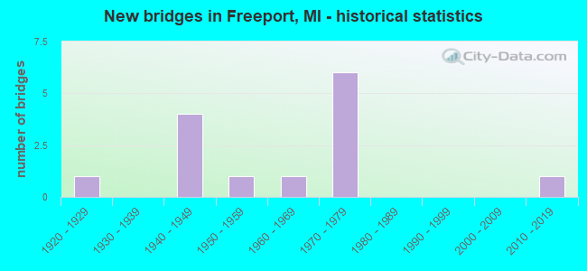
- New bridges - historical statistics
- 11920-1929
- 41940-1949
- 11950-1959
- 11960-1969
- 61970-1979
- 12010-2019
FCC Registered Antenna Towers:
35 (See the full list of FCC Registered Antenna Towers in Freeport)FCC Registered Broadcast Land Mobile Towers:
2- Lat: 42.775333 Lon: -85.315806, Call Sign: WQUW383,
Assigned Frequencies: 469.337 MHz, 469.337 MHz, Grant Date: 10/30/2014, Expiration Date: 10/30/2024, Certifier: Phil Geerlings, Registrant: Chrouch Communications, Inc., 7860 Morrison Lake Road, Saranac, MI 48881, Phone: (616) 642-3881, Fax: (616) 642-6008, Email:
- Lat: 42.768806 Lon: -85.320417, Call Sign: WRPH660,
Assigned Frequencies: 451.437 MHz, 452.312 MHz, 456.437 MHz, 457.312 MHz, 457.887 MHz, Grant Date: 02/04/2022, Expiration Date: 02/04/2032, Certifier: Stacey Howell, Registrant: Tele-Rad, Inc., 511 East 8th Street, Holland, MI 49423, Phone: (616) 396-3541, Fax: (616) 392-9707, Email:
FCC Registered Microwave Towers:
4- DE34IP347, 4239 E. M43 Highway (Lat: 42.728222 Lon: -85.205778), Type: Ltower, Structure height: 90.2 m, Overall height: 94.5 m, Call Sign: WQQN527,
Assigned Frequencies: 10755.0 MHz, 10755.0 MHz, 10755.0 MHz, Grant Date: 02/01/2013, Expiration Date: 02/01/2023, Cancellation Date: 01/30/2023, Certifier: David Werblow, Registrant: T-Mobile Usa, Inc., 12920 Se 38th St, Bellevue, WA 98006, Phone: (425) 383-8401, Fax: (425) 383-4840, Email:
- DE34IP748, Freeport (305592) (Lat: 42.804333 Lon: -85.272806), Type: Mtower, Structure height: 57.3 m, Overall height: 60.4 m, Call Sign: WQQR643,
Assigned Frequencies: 10895.0 MHz, Grant Date: 02/19/2013, Expiration Date: 02/19/2023, Cancellation Date: 02/09/2023, Certifier: David Werblow, Registrant: T-Mobile Usa, Inc., 12920 Se 38th St, Bellevue, WA 98006, Phone: (425) 383-8401, Fax: (425) 383-4840, Email:
- GS02397A, 4239 E. M43 Highway (Lat: 42.728222 Lon: -85.205778), Type: Ltower, Structure height: 90.2 m, Overall height: 94.5 m, Call Sign: WQXJ512,
Assigned Frequencies: 10935.0 MHz, 10935.0 MHz, 10935.0 MHz, 10935.0 MHz, 10935.0 MHz, 10935.0 MHz, 10935.0 MHz, 10935.0 MHz, Grant Date: 03/23/2016, Expiration Date: 03/23/2026, Cancellation Date: 02/13/2023, Certifier: David Werblow, Registrant: T-Mobile Usa, Inc., 12920 Se 38th Street, Bellevue, WA 98006, Phone: (425) 383-8401, Fax: (425) 383-4040, Email:
- MI01313, 4239 E. M43 Highway (Lat: 42.728222 Lon: -85.205778), Type: Gtower, Structure height: 90.2 m, Overall height: 94.5 m, Call Sign: WRYE952, Licensee ID: L02016256,
Assigned Frequencies: 11325.0 MHz, 19460.0 MHz, 11325.0 MHz, 19460.0 MHz, 11325.0 MHz, 19460.0 MHz, 11325.0 MHz, 19460.0 MHz, 11325.0 MHz, 19460.0 MHz... (+14 more), Grant Date: 08/01/2023, Expiration Date: 08/01/2033, Certifier: Garrett Wiseman, Registrant: Mercury Wireless Indiana, LLC, 6004 Highview Drive, Suite B, Fort Wayne, IN 46818, Phone: (800) 354-4915, Email:
FCC Registered Amateur Radio Licenses:
20 (See the full list of FCC Registered Amateur Radio Licenses in Freeport)| Home Mortgage Disclosure Act Aggregated Statistics For Year 2009 (Based on 1 partial tract) | ||
| C) Refinancings | ||
|---|---|---|
| Number | Average Value | |
| LOANS ORIGINATED | 1 | $154,560 |
| APPLICATIONS APPROVED, NOT ACCEPTED | 0 | $0 |
| APPLICATIONS DENIED | 1 | $77,300 |
| APPLICATIONS WITHDRAWN | 0 | $0 |
| FILES CLOSED FOR INCOMPLETENESS | 0 | $0 |
Detailed HMDA statistics for the following Tracts: 0102.00

2002 - 2018 National Fire Incident Reporting System (NFIRS) incidents
- Fire incident types reported to NFIRS in Freeport, MI
- 11248.7%Structure Fires
- 8135.2%Outside Fires
- 2410.4%Mobile Property/Vehicle Fires
- 135.7%Other
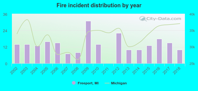 Based on the data from the years 2002 - 2018 the average number of fire incidents per year is 14. The highest number of reported fire incidents - 31 took place in 2009, and the least - 0 in 2011. The data has a dropping trend.
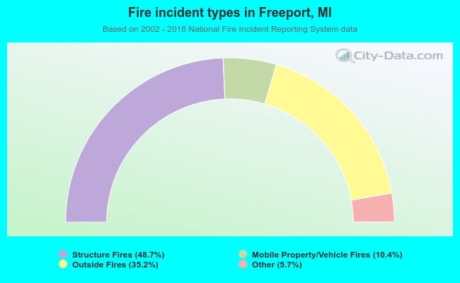 When looking into fire subcategories, the most incidents belonged to: Structure Fires (48.7%), and Outside Fires (35.2%).
| Most common first names in Freeport, MI among deceased individuals | ||
| Name | Count | Lived (average) |
|---|---|---|
| John | 10 | 73.7 years |
| William | 10 | 69.3 years |
| Charles | 9 | 67.8 years |
| Robert | 9 | 76.5 years |
| George | 7 | 79.7 years |
| Arthur | 5 | 76.0 years |
| Frank | 4 | 72.5 years |
| Albert | 4 | 68.0 years |
| Henry | 4 | 83.8 years |
| Mary | 4 | 87.5 years |
| Most common last names in Freeport, MI among deceased individuals | ||
| Last name | Count | Lived (average) |
|---|---|---|
| Blough | 10 | 75.9 years |
| King | 7 | 82.3 years |
| Miller | 7 | 81.7 years |
| Allerding | 5 | 76.8 years |
| Bird | 5 | 75.0 years |
| Smith | 5 | 82.2 years |
| Thompson | 5 | 84.2 years |
| Endres | 4 | 78.5 years |
| Dipp | 4 | 63.8 years |
| Davis | 4 | 72.5 years |
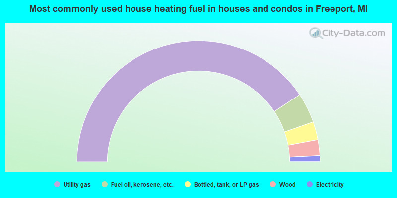
- 81.4%Utility gas
- 8.0%Fuel oil, kerosene, etc.
- 4.8%Bottled, tank, or LP gas
- 4.3%Wood
- 1.6%Electricity
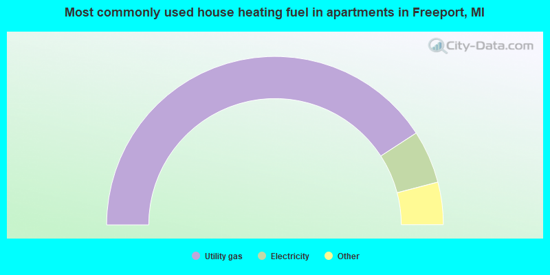
- 84.2%Utility gas
- 10.5%Electricity
- 3.5%No fuel used
- 1.8%Bottled, tank, or LP gas
Freeport compared to Michigan state average:
- Unemployed percentage significantly below state average.
- Black race population percentage significantly below state average.
- Hispanic race population percentage above state average.
- Median age below state average.
- Foreign-born population percentage significantly below state average.
- House age above state average.
State forum archive:

|
Total of 1 patent application in 2008-2024.